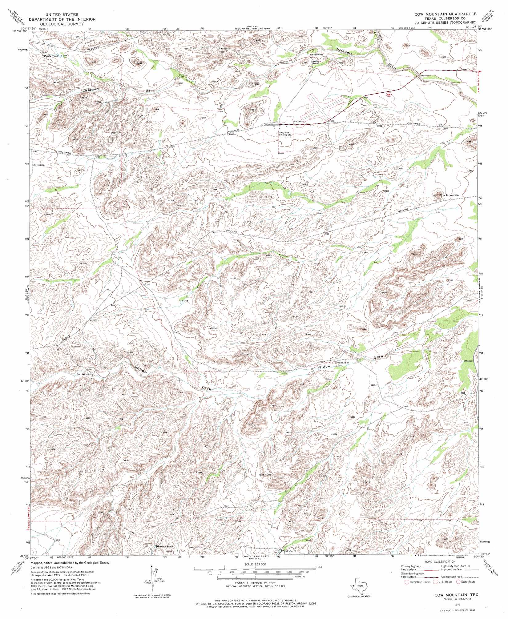
Cow Mountain Topo Map Texas
To zoom in, hover over the map of Cow Mountain
USGS Topo Quad 31104g5 - 1:24,000 scale
| Topo Map Name: | Cow Mountain |
| USGS Topo Quad ID: | 31104g5 |
| Print Size: | ca. 21 1/4" wide x 27" high |
| Southeast Coordinates: | 31.75° N latitude / 104.5° W longitude |
| Map Center Coordinates: | 31.8125° N latitude / 104.5625° W longitude |
| U.S. State: | TX |
| Filename: | o31104g5.jpg |
| Download Map JPG Image: | Cow Mountain topo map 1:24,000 scale |
| Map Type: | Topographic |
| Topo Series: | 7.5´ |
| Map Scale: | 1:24,000 |
| Source of Map Images: | United States Geological Survey (USGS) |
| Alternate Map Versions: |
Cow Mountain TX 1973, updated 1976 Download PDF Buy paper map Cow Mountain TX 2010 Download PDF Buy paper map Cow Mountain TX 2012 Download PDF Buy paper map Cow Mountain TX 2016 Download PDF Buy paper map |
1:24,000 Topo Quads surrounding Cow Mountain
El Paso Gap |
Gunsight Canyon |
Grapevine Draw |
Rattlesnake Spring |
Jumping Spring |
Guadalupe Peak |
Independence Spring |
South Rector Canyon |
Alligator Draw |
Outlaw Spring |
Guadalupe Pass |
Long Point |
Cow Mountain |
Delaware Spring |
Castile Hill |
Six Bar Ranch |
Chico Draw West |
Chico Draw East |
Seven L Peak |
Seven L Peak Ne |
Bitter Well Mountain |
Burro Canyon |
Emory Corral |
Kc Ranch |
Two Mill Draw West |
> Back to 31104e1 at 1:100,000 scale
> Back to 31104a1 at 1:250,000 scale
> Back to U.S. Topo Maps home
Cow Mountain topo map: Gazetteer
Cow Mountain: Lakes
Middle Tank elevation 1271m 4169′Tank Number Twelve elevation 1281m 4202′
White Tank elevation 1220m 4002′
Cow Mountain: Reservoirs
Division Tank elevation 1335m 4379′Cow Mountain: Summits
Cow Mountain elevation 1206m 3956′Cow Mountain: Valleys
Lamar Canyon elevation 1168m 3832′Cow Mountain: Wells
Walker Wells elevation 1186m 3891′Cow Mountain digital topo map on disk
Buy this Cow Mountain topo map showing relief, roads, GPS coordinates and other geographical features, as a high-resolution digital map file on DVD: