Guadalupe Pass Topo Map Texas
To zoom in, hover over the map of Guadalupe Pass
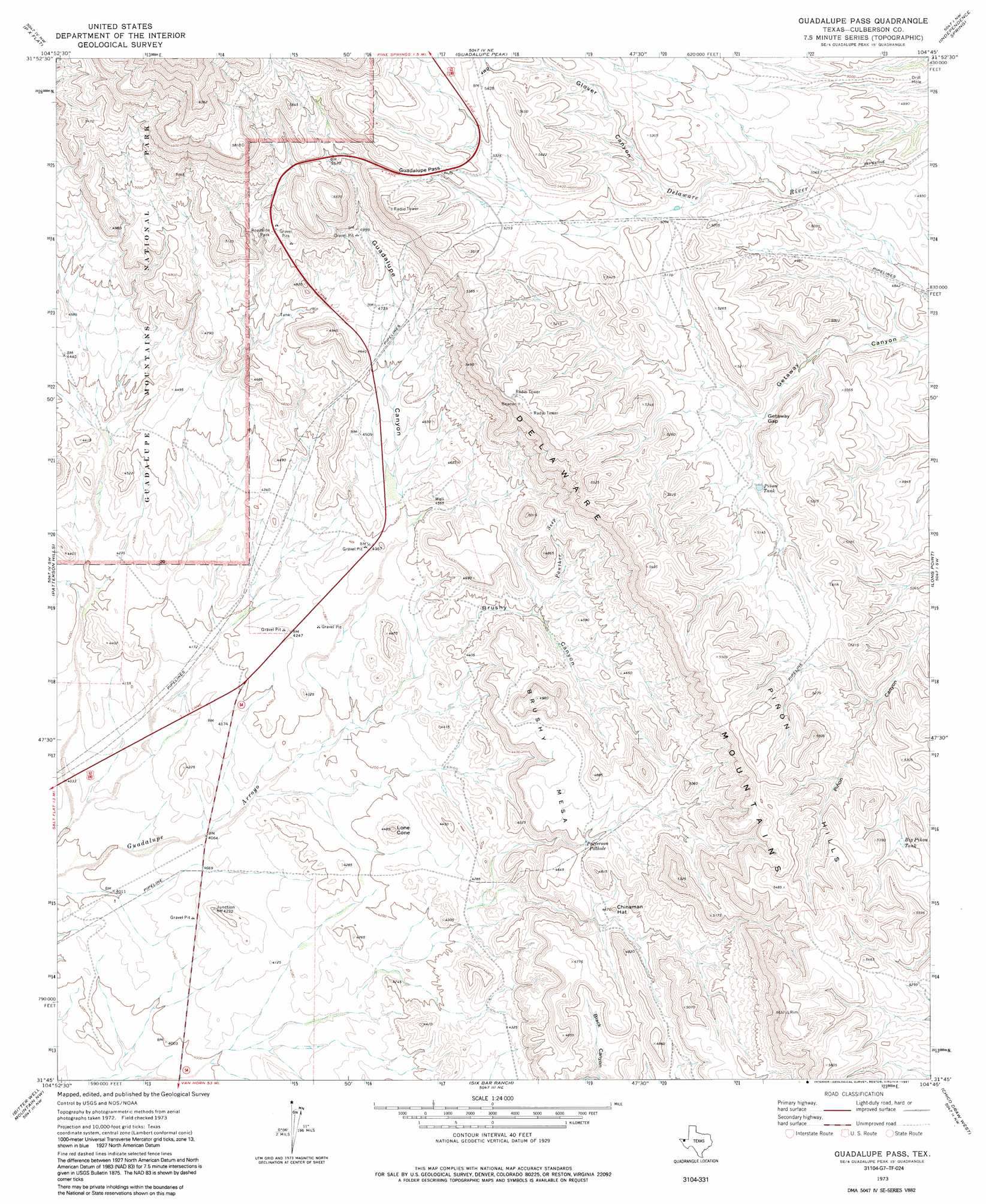
USGS Topo Quad 31104g7 - 1:24,000 scale
| Topo Map Name: | Guadalupe Pass |
| USGS Topo Quad ID: | 31104g7 |
| Print Size: | ca. 21 1/4" wide x 27" high |
| Southeast Coordinates: | 31.75° N latitude / 104.75° W longitude |
| Map Center Coordinates: | 31.8125° N latitude / 104.8125° W longitude |
| U.S. State: | TX |
| Filename: | o31104g7.jpg |
| Download Map JPG Image: | Guadalupe Pass topo map 1:24,000 scale |
| Map Type: | Topographic |
| Topo Series: | 7.5´ |
| Map Scale: | 1:24,000 |
| Source of Map Images: | United States Geological Survey (USGS) |
| Alternate Map Versions: |
Guadalupe Pass TX 1973, updated 1977 Download PDF Buy paper map Guadalupe Pass TX 1973, updated 1991 Download PDF Buy paper map Guadalupe Pass TX 2011 Download PDF Buy paper map Guadalupe Pass TX 2012 Download PDF Buy paper map Guadalupe Pass TX 2016 Download PDF Buy paper map |
1:24,000 Topo Quads surrounding Guadalupe Pass
Cienega School |
Panther Canyon |
El Paso Gap |
Gunsight Canyon |
Grapevine Draw |
Linda Lake North |
P X Flat |
Guadalupe Peak |
Independence Spring |
South Rector Canyon |
Linda Lake South |
Patterson Hills |
Guadalupe Pass |
Long Point |
Cow Mountain |
Salt Flat |
Bitter Well Mountain Nw |
Six Bar Ranch |
Chico Draw West |
Chico Draw East |
Babb Canyon |
Bitter Well Mountain Sw |
Bitter Well Mountain |
Burro Canyon |
Emory Corral |
> Back to 31104e1 at 1:100,000 scale
> Back to 31104a1 at 1:250,000 scale
> Back to U.S. Topo Maps home
Guadalupe Pass topo map: Gazetteer
Guadalupe Pass: Basins
Patterson Pothole elevation 1394m 4573′Guadalupe Pass: Gaps
Getaway Gap elevation 1482m 4862′Guadalupe Pass elevation 1650m 5413′
Guadalupe Pass: Reservoirs
Big Piñon Tank elevation 1569m 5147′Piñon Tank elevation 1503m 4931′
Guadalupe Pass: Streams
Panther Seep elevation 1343m 4406′Guadalupe Pass: Summits
Brushy Mesa elevation 1428m 4685′Chinaman Hat elevation 1401m 4596′
Lone Cone elevation 1340m 4396′
Piñon Hills elevation 1672m 5485′
Guadalupe Pass: Trails
El Capitan Trail elevation 1926m 6318′Guadalupe Pass: Valleys
Brushy Canyon elevation 1323m 4340′Getaway Canyon elevation 1438m 4717′
Glover Canyon elevation 1575m 5167′
Guadalupe Canyon elevation 1341m 4399′
Guadalupe Pass digital topo map on disk
Buy this Guadalupe Pass topo map showing relief, roads, GPS coordinates and other geographical features, as a high-resolution digital map file on DVD: