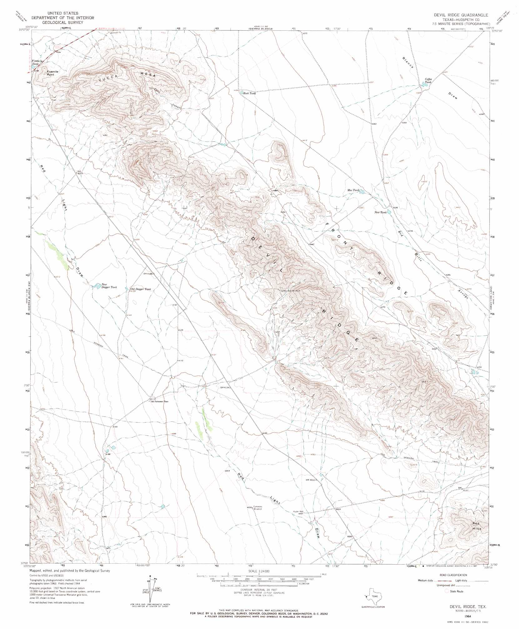
Devil Ridge Topo Map Texas
To zoom in, hover over the map of Devil Ridge
USGS Topo Quad 31105a3 - 1:24,000 scale
| Topo Map Name: | Devil Ridge |
| USGS Topo Quad ID: | 31105a3 |
| Print Size: | ca. 21 1/4" wide x 27" high |
| Southeast Coordinates: | 31° N latitude / 105.25° W longitude |
| Map Center Coordinates: | 31.0625° N latitude / 105.3125° W longitude |
| U.S. State: | TX |
| Filename: | o31105a3.jpg |
| Download Map JPG Image: | Devil Ridge topo map 1:24,000 scale |
| Map Type: | Topographic |
| Topo Series: | 7.5´ |
| Map Scale: | 1:24,000 |
| Source of Map Images: | United States Geological Survey (USGS) |
| Alternate Map Versions: |
Devil Ridge TX 1964, updated 1967 Download PDF Buy paper map Devil Ridge TX 2010 Download PDF Buy paper map Devil Ridge TX 2012 Download PDF Buy paper map Devil Ridge TX 2016 Download PDF Buy paper map |
1:24,000 Topo Quads surrounding Devil Ridge
Small |
Gunsight Hills South |
Pierce Ranch |
Movie Mountain |
Sneed Mountain |
Silver King Canyon |
Lasca |
Sierra Blanca |
Dome Peak |
Bean Hills |
Neely Canyon |
Sierra Blanca Sw |
Devil Ridge |
Grayton Lake |
Allamoore |
Schroder Arroyo |
Cedar Arroyo |
Eagle Mountains Nw |
Eagle Mountains Ne |
|
Indian Hot Springs |
Eagle Mountains Sw |
Eagle Mountains Se |
> Back to 31105a1 at 1:100,000 scale
> Back to 31104a1 at 1:250,000 scale
> Back to U.S. Topo Maps home
Devil Ridge topo map: Gazetteer
Devil Ridge: Populated Places
Old Patterson Place elevation 1254m 4114′Devil Ridge: Reservoirs
Coffee Tank elevation 1317m 4320′Fivemile Tank elevation 1334m 4376′
Mac Tank elevation 1326m 4350′
New Dagger Tank elevation 1273m 4176′
New Tank elevation 1320m 4330′
Old Dagger Tank elevation 1269m 4163′
Rock Tank elevation 1366m 4481′
Devil Ridge: Ridges
Devil Ridge elevation 1474m 4835′Front Ridge elevation 1394m 4573′
Devil Ridge: Summits
Fivemile Point elevation 1403m 4603′Red Hills elevation 1333m 4373′
Yucca Mesa elevation 1612m 5288′
Devil Ridge: Valleys
Echo Canyon elevation 1390m 4560′Devil Ridge: Wells
Hayter Well elevation 1222m 4009′Devil Ridge digital topo map on disk
Buy this Devil Ridge topo map showing relief, roads, GPS coordinates and other geographical features, as a high-resolution digital map file on DVD: