Cerro Diablo Topo Map Texas
To zoom in, hover over the map of Cerro Diablo
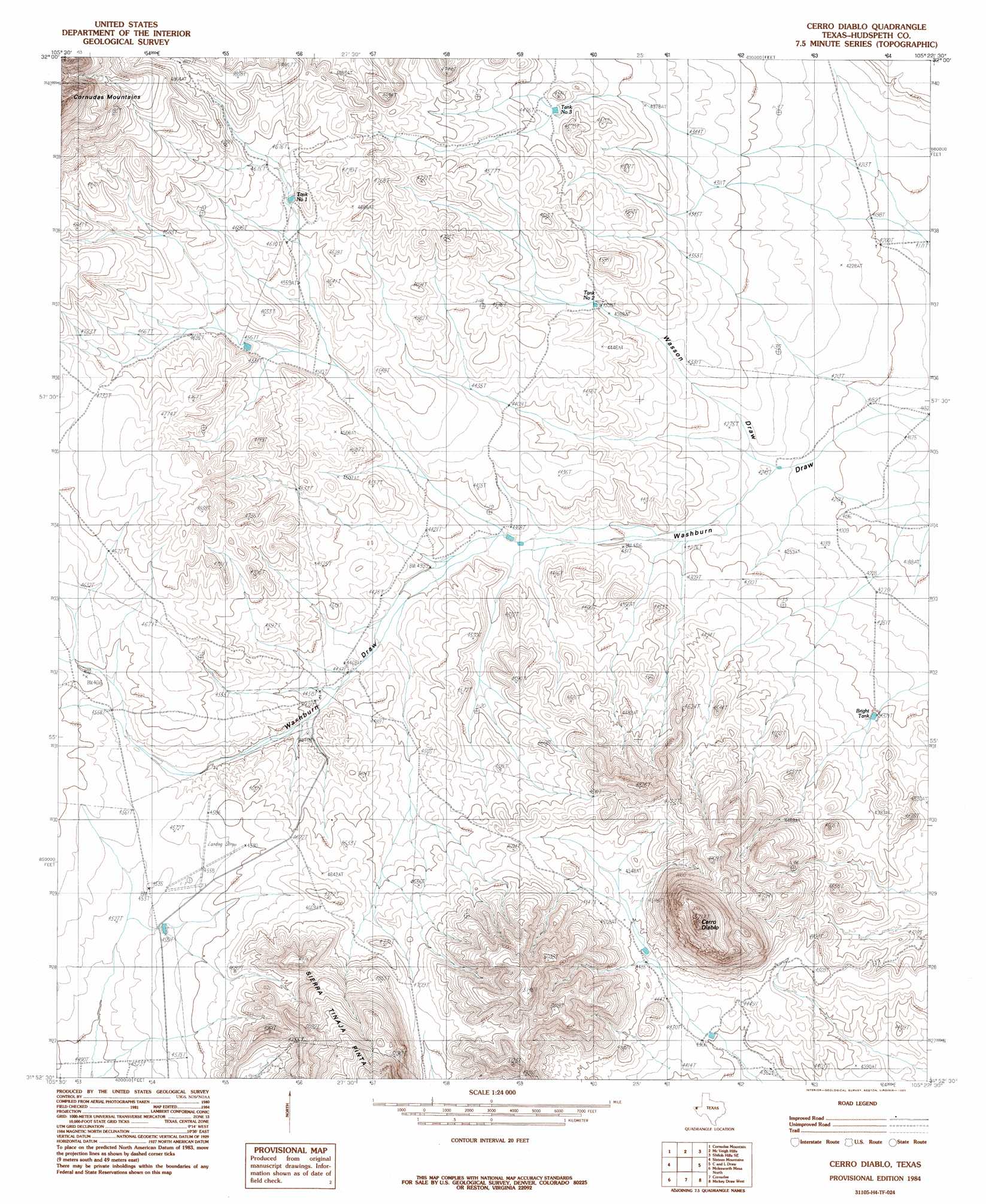
USGS Topo Quad 31105h4 - 1:24,000 scale
| Topo Map Name: | Cerro Diablo |
| USGS Topo Quad ID: | 31105h4 |
| Print Size: | ca. 21 1/4" wide x 27" high |
| Southeast Coordinates: | 31.875° N latitude / 105.375° W longitude |
| Map Center Coordinates: | 31.9375° N latitude / 105.4375° W longitude |
| U.S. State: | TX |
| Filename: | o31105h4.jpg |
| Download Map JPG Image: | Cerro Diablo topo map 1:24,000 scale |
| Map Type: | Topographic |
| Topo Series: | 7.5´ |
| Map Scale: | 1:24,000 |
| Source of Map Images: | United States Geological Survey (USGS) |
| Alternate Map Versions: |
Cerro Diablo TX 1984, updated 1985 Download PDF Buy paper map Cerro Diablo TX 2010 Download PDF Buy paper map Cerro Diablo TX 2013 Download PDF Buy paper map Cerro Diablo TX 2016 Download PDF Buy paper map |
1:24,000 Topo Quads surrounding Cerro Diablo
B T Ranch |
Alamo Mountain Ne |
Shiloh Hills |
Van Winkle Lake |
Lewis Canyon |
Alamo Mountain |
Cornudas Mountain |
Mcveigh Hills |
Shiloh Hills Se |
Culp Draw |
Big Heiser Tank |
Sixteen Mountains |
Cerro Diablo |
C And L Draw |
Dell City |
Buckhorn Draw East |
Molesworth Mesa North |
Cornudas |
Mickey Draw West |
Mickey Draw East |
Tepee Butte |
Molesworth Mesa South |
Adobe House Tank |
Hueco Station |
Black Mountains Nw |
> Back to 31105e1 at 1:100,000 scale
> Back to 31104a1 at 1:250,000 scale
> Back to U.S. Topo Maps home
Cerro Diablo topo map: Gazetteer
Cerro Diablo: Airports
Mayfield Ranch Airport elevation 1390m 4560′Cerro Diablo: Reservoirs
Bright Tank elevation 1317m 4320′Peace Tank elevation 1329m 4360′
Tank Number One elevation 1415m 4642′
Tank Number Three elevation 1346m 4416′
Tank Number Two elevation 1365m 4478′
Cerro Diablo: Streams
Wasson Draw elevation 1291m 4235′Cerro Diablo: Summits
Cerro Diablo elevation 1728m 5669′Cerro Diablo: Wells
Carpers Well elevation 1282m 4206′Cerro Diablo digital topo map on disk
Buy this Cerro Diablo topo map showing relief, roads, GPS coordinates and other geographical features, as a high-resolution digital map file on DVD: