Cerro Alto Mountain Topo Map Texas
To zoom in, hover over the map of Cerro Alto Mountain
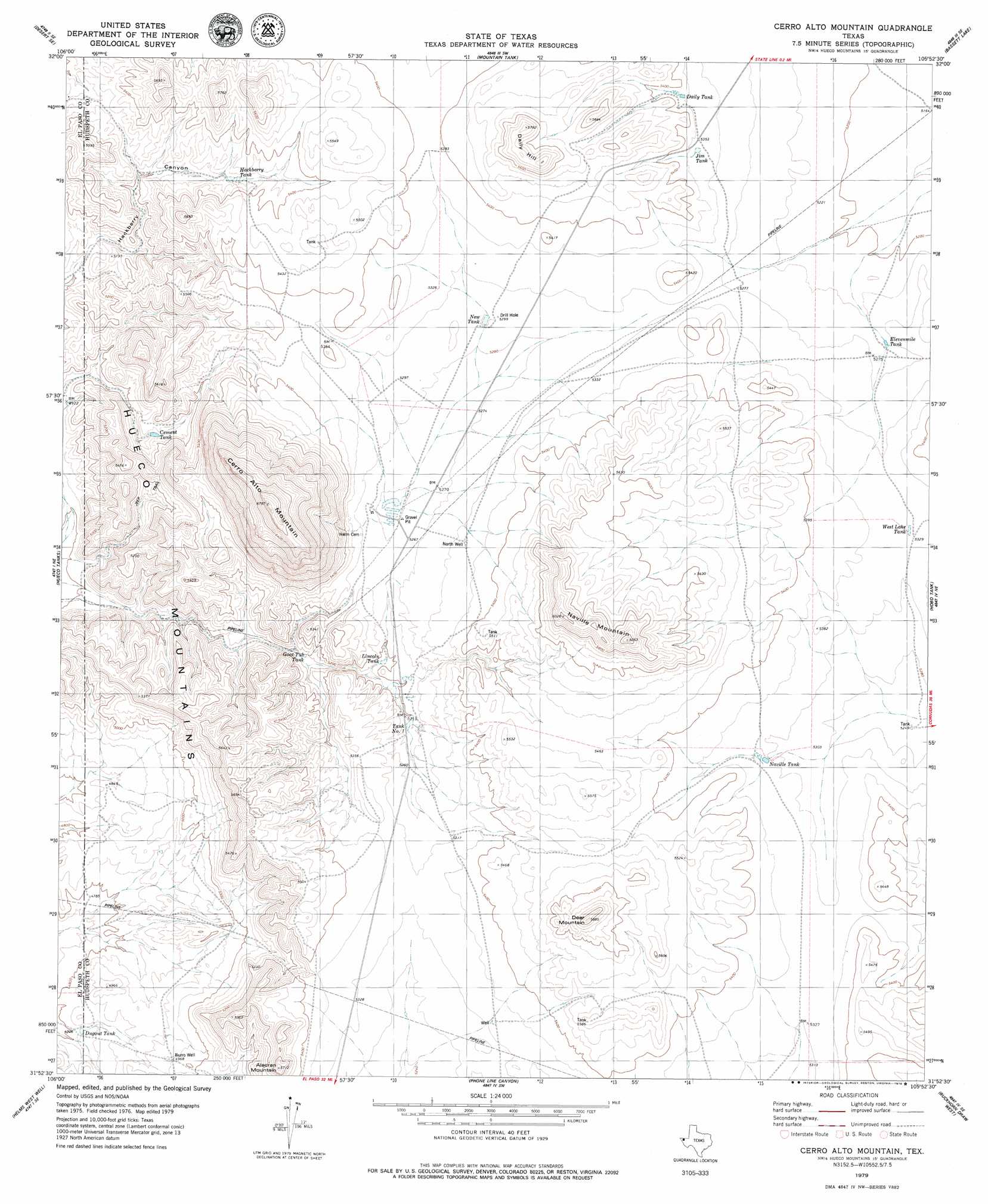
USGS Topo Quad 31105h8 - 1:24,000 scale
| Topo Map Name: | Cerro Alto Mountain |
| USGS Topo Quad ID: | 31105h8 |
| Print Size: | ca. 21 1/4" wide x 27" high |
| Southeast Coordinates: | 31.875° N latitude / 105.875° W longitude |
| Map Center Coordinates: | 31.9375° N latitude / 105.9375° W longitude |
| U.S. State: | TX |
| Filename: | o31105h8.jpg |
| Download Map JPG Image: | Cerro Alto Mountain topo map 1:24,000 scale |
| Map Type: | Topographic |
| Topo Series: | 7.5´ |
| Map Scale: | 1:24,000 |
| Source of Map Images: | United States Geological Survey (USGS) |
| Alternate Map Versions: |
Cerro Alto Mountain TX 2010 Download PDF Buy paper map Cerro Alto Mountain TX 2013 Download PDF Buy paper map Cerro Alto Mountain TX 2016 Download PDF Buy paper map |
1:24,000 Topo Quads surrounding Cerro Alto Mountain
Desert |
Desert Ne |
Owl Tank Canyon West |
Owl Tank Canyon East |
B T Ranch |
Desert Sw |
Desert Se |
Mountain Tank |
Alamo Mountain |
Alamo Mountain |
Nations East Well |
Hueco Tanks |
Cerro Alto Mountain |
Hobo Tank |
Big Heiser Tank |
Nations South Well |
Helms West Well |
Phone Line Canyon |
Buckhorn Draw West |
Buckhorn Draw East |
Clint Nw |
Clint Ne |
Padre Canyon |
Wildhorse Draw |
Tepee Butte |
> Back to 31105e1 at 1:100,000 scale
> Back to 31104a1 at 1:250,000 scale
> Back to U.S. Topo Maps home
Cerro Alto Mountain topo map: Gazetteer
Cerro Alto Mountain: Reservoirs
Cement Tank elevation 1558m 5111′Daily Tank elevation 1634m 5360′
Dugout Tank elevation 1473m 4832′
Elevenmile Tank elevation 1609m 5278′
Goat Tub Tank elevation 1562m 5124′
Hackberry Tank elevation 1620m 5314′
Jim Tank elevation 1628m 5341′
Lincoln Tank elevation 1584m 5196′
Naville Tank elevation 1623m 5324′
New Tank elevation 1615m 5298′
Tank Number One elevation 1593m 5226′
West Lake Tank elevation 1629m 5344′
Cerro Alto Mountain: Summits
Alacran Mountain elevation 1732m 5682′Cerro Alto Mountain elevation 2043m 6702′
Daily Hill elevation 1725m 5659′
Deer Mountain elevation 1787m 5862′
Naville Mountain elevation 1819m 5967′
Cerro Alto Mountain: Valleys
Hackberry Canyon elevation 1544m 5065′Cerro Alto Mountain: Wells
Burro Well elevation 1513m 4963′North Well elevation 1627m 5337′
Well Number One elevation 1625m 5331′
Cerro Alto Mountain digital topo map on disk
Buy this Cerro Alto Mountain topo map showing relief, roads, GPS coordinates and other geographical features, as a high-resolution digital map file on DVD: