Clint Se Topo Map Texas
To zoom in, hover over the map of Clint Se
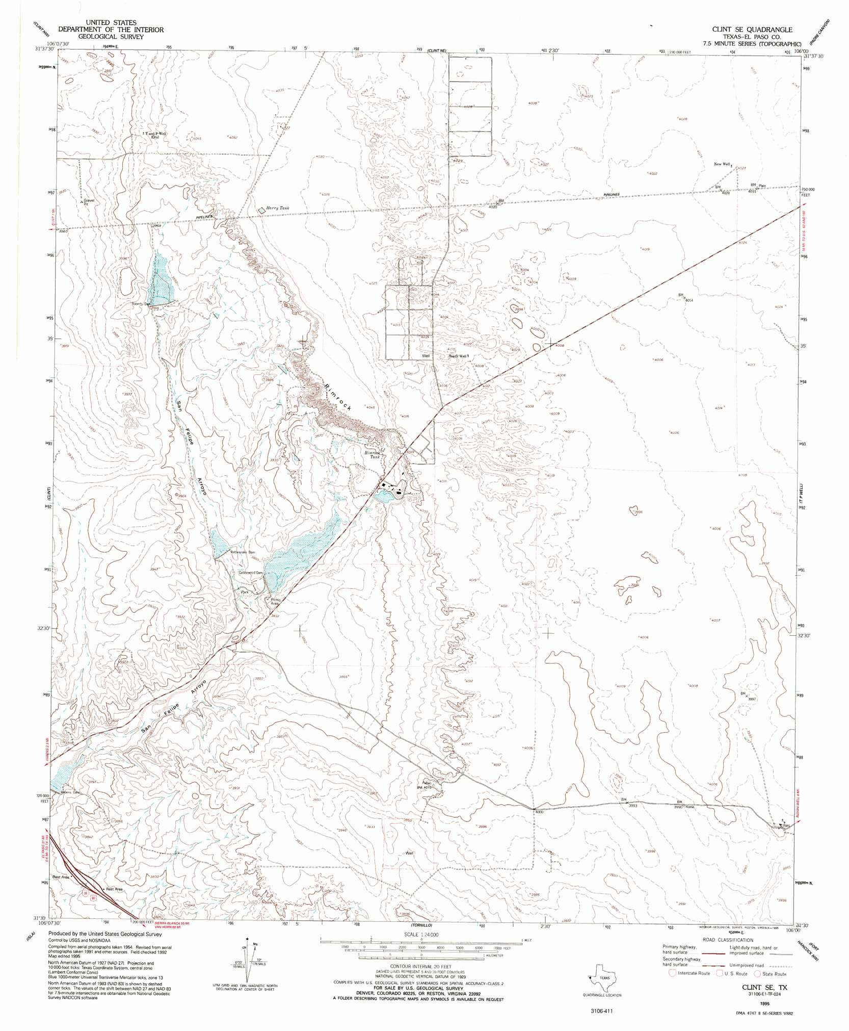
USGS Topo Quad 31106e1 - 1:24,000 scale
| Topo Map Name: | Clint Se |
| USGS Topo Quad ID: | 31106e1 |
| Print Size: | ca. 21 1/4" wide x 27" high |
| Southeast Coordinates: | 31.5° N latitude / 106° W longitude |
| Map Center Coordinates: | 31.5625° N latitude / 106.0625° W longitude |
| U.S. State: | TX |
| Filename: | o31106e1.jpg |
| Download Map JPG Image: | Clint Se topo map 1:24,000 scale |
| Map Type: | Topographic |
| Topo Series: | 7.5´ |
| Map Scale: | 1:24,000 |
| Source of Map Images: | United States Geological Survey (USGS) |
| Alternate Map Versions: |
Clint SE TX 1955, updated 1959 Download PDF Buy paper map Clint SE TX 1955, updated 1974 Download PDF Buy paper map Clint SE TX 1995, updated 1995 Download PDF Buy paper map Clint SE TX 2010 Download PDF Buy paper map Clint SE TX 2012 Download PDF Buy paper map Clint SE TX 2016 Download PDF Buy paper map |
1:24,000 Topo Quads surrounding Clint Se
Fort Bliss Se |
Nations South Well |
Helms West Well |
Phone Line Canyon |
Buckhorn Draw West |
Ysleta |
Clint Nw |
Clint Ne |
Padre Canyon |
Wildhorse Draw |
San Elizario |
Clint |
Clint Se |
T P Well |
Whiterock Hills |
Isla |
Tornillo |
Fort Hancock Nw |
Cavett Lake |
|
Acala |
Fort Hancock |
> Back to 31106e1 at 1:100,000 scale
> Back to 31106a1 at 1:250,000 scale
> Back to U.S. Topo Maps home
Clint Se topo map: Gazetteer
Clint Se: Cliffs
Rimrock elevation 1219m 3999′Clint Se: Dams
Cottonwood Dam elevation 1166m 3825′Indian Cliff Ranch Main Lake Dam elevation 1185m 3887′
Rattlesnake Dam elevation 1168m 3832′
Roberts Dam elevation 1199m 3933′
Roberts Tank Dam elevation 1200m 3937′
Clint Se: Populated Places
Cattleman's North Ranchos Colonia elevation 1229m 4032′Cattleman's North Ranchos Number 2 Colonia elevation 1229m 4032′
East Clint Estates Colonia elevation 1220m 4002′
Clint Se: Reservoirs
Cottonwood Lake elevation 1166m 3825′Harry Tank elevation 1230m 4035′
Indian Cliffs Ranch Main Lake elevation 1185m 3887′
Rattlesnake Lake elevation 1169m 3835′
Rimrock Tank elevation 1192m 3910′
Roberts Tank elevation 1200m 3937′
Clint Se: Wells
New Well elevation 1228m 4028′T and P Well elevation 1224m 4015′
Clint Se digital topo map on disk
Buy this Clint Se topo map showing relief, roads, GPS coordinates and other geographical features, as a high-resolution digital map file on DVD: