Malpais Hill Topo Map New Mexico
To zoom in, hover over the map of Malpais Hill
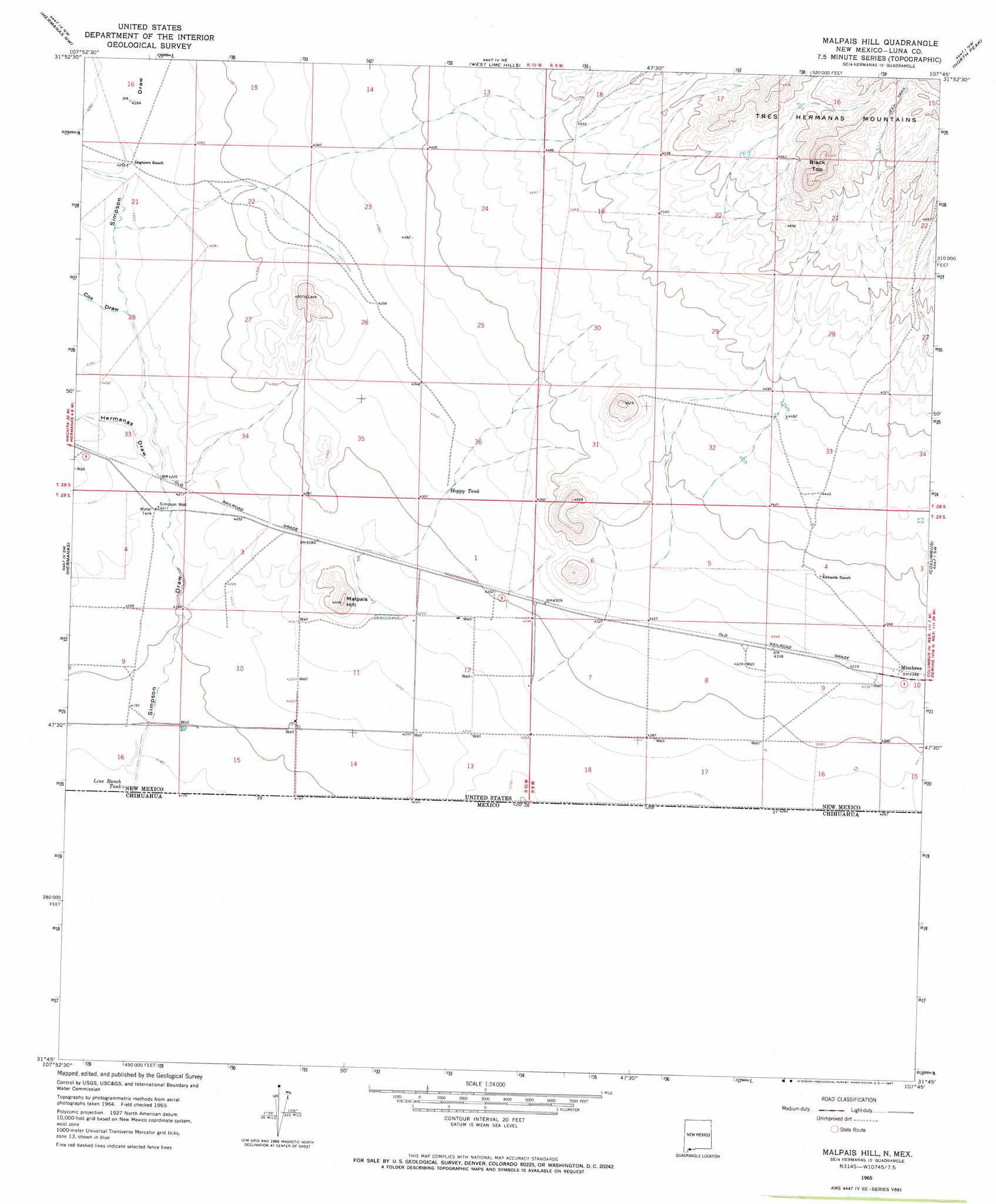
USGS Topo Quad 31107g7 - 1:24,000 scale
| Topo Map Name: | Malpais Hill |
| USGS Topo Quad ID: | 31107g7 |
| Print Size: | ca. 21 1/4" wide x 27" high |
| Southeast Coordinates: | 31.75° N latitude / 107.75° W longitude |
| Map Center Coordinates: | 31.8125° N latitude / 107.8125° W longitude |
| U.S. State: | NM |
| Filename: | o31107g7.jpg |
| Download Map JPG Image: | Malpais Hill topo map 1:24,000 scale |
| Map Type: | Topographic |
| Topo Series: | 7.5´ |
| Map Scale: | 1:24,000 |
| Source of Map Images: | United States Geological Survey (USGS) |
| Alternate Map Versions: |
Malpais Hill NM 1965, updated 1967 Download PDF Buy paper map Malpais Hill NM 1996, updated 2002 Download PDF Buy paper map Malpais Hill NM 2010 Download PDF Buy paper map Malpais Hill NM 2013 Download PDF Buy paper map Malpais Hill NM 2017 Download PDF Buy paper map |
1:24,000 Topo Quads surrounding Malpais Hill
Gage Se |
Bisbee Hills |
Midway Butte |
South Peak |
Gym Peak |
Flying W Mountain |
Hermanas Nw |
West Lime Hills |
North Peak |
Columbus Ne |
Victorio Ranch Se |
Hermanas |
Malpais Hill |
Columbus |
Columbus Se |
> Back to 31107e1 at 1:100,000 scale
> Back to 31106a1 at 1:250,000 scale
> Back to U.S. Topo Maps home
Malpais Hill topo map: Gazetteer
Malpais Hill: Populated Places
Mimbres elevation 1325m 4347′Malpais Hill: Reservoirs
Hoppy Tank elevation 1318m 4324′Line Ranch Tank elevation 1274m 4179′
Malpais Hill: Summits
Black Top elevation 1527m 5009′Malpais Hill elevation 1331m 4366′
Malpais Hill: Valleys
Cox Draw elevation 1293m 4242′Hermanas Draw elevation 1286m 4219′
Simpson Draw elevation 1274m 4179′
Malpais Hill: Wells
001161 Water Well elevation 1283m 4209′01077 Water Well elevation 1299m 4261′
01124 Water Well elevation 1336m 4383′
01126 Water Well elevation 1321m 4333′
01127 Water Well elevation 1319m 4327′
01129 Water Well elevation 1319m 4327′
01130 Water Well elevation 1326m 4350′
01134 Water Well elevation 1317m 4320′
01136 Water Well elevation 1286m 4219′
01141 Water Well elevation 1295m 4248′
01149 Water Well elevation 1296m 4251′
01150 Water Well elevation 1292m 4238′
01151 Water Well elevation 1288m 4225′
01153 Water Well elevation 1297m 4255′
01154 Water Well elevation 1295m 4248′
01155 Water Well elevation 1307m 4288′
01157 Water Well elevation 1301m 4268′
01159 Water Well elevation 1306m 4284′
01162 Water Well elevation 1280m 4199′
01650 Water Well elevation 1367m 4484′
01657 Water Well elevation 1311m 4301′
01658 Water Well elevation 1281m 4202′
06126 Water Well elevation 1301m 4268′
06127 Water Well elevation 1318m 4324′
06157 Water Well elevation 1320m 4330′
10429 Water Well elevation 1332m 4370′
10430 Water Well elevation 1320m 4330′
10431 Water Well elevation 1320m 4330′
10432 Water Well elevation 1308m 4291′
10433 Water Well elevation 1308m 4291′
10437 Water Well elevation 1285m 4215′
10438 Water Well elevation 1309m 4294′
10439 Water Well elevation 1300m 4265′
10440 Water Well elevation 1300m 4265′
10441 Water Well elevation 1278m 4192′
1078 Water Well elevation 1326m 4350′
M-3928 Water Well elevation 1329m 4360′
Simpson Well elevation 1286m 4219′
Malpais Hill digital topo map on disk
Buy this Malpais Hill topo map showing relief, roads, GPS coordinates and other geographical features, as a high-resolution digital map file on DVD: