Columbus Ne Topo Map New Mexico
To zoom in, hover over the map of Columbus Ne
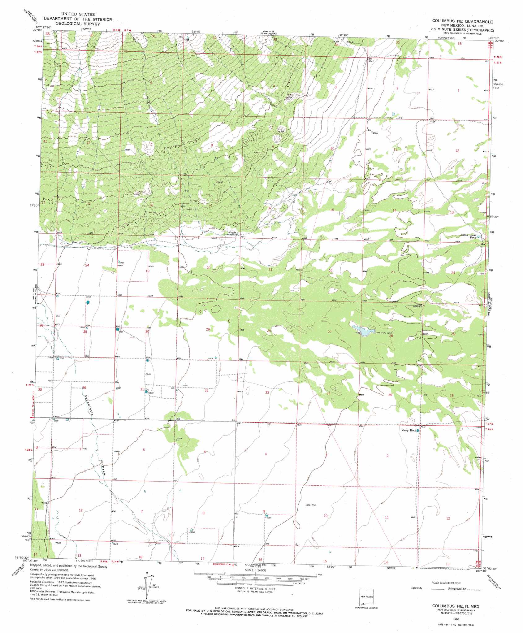
USGS Topo Quad 31107h5 - 1:24,000 scale
| Topo Map Name: | Columbus Ne |
| USGS Topo Quad ID: | 31107h5 |
| Print Size: | ca. 21 1/4" wide x 27" high |
| Southeast Coordinates: | 31.875° N latitude / 107.5° W longitude |
| Map Center Coordinates: | 31.9375° N latitude / 107.5625° W longitude |
| U.S. State: | NM |
| Filename: | o31107h5.jpg |
| Download Map JPG Image: | Columbus Ne topo map 1:24,000 scale |
| Map Type: | Topographic |
| Topo Series: | 7.5´ |
| Map Scale: | 1:24,000 |
| Source of Map Images: | United States Geological Survey (USGS) |
| Alternate Map Versions: |
Columbus NE NM 1966, updated 1967 Download PDF Buy paper map Columbus NE NM 1996, updated 2003 Download PDF Buy paper map Columbus NE NM 2010 Download PDF Buy paper map Columbus NE NM 2013 Download PDF Buy paper map Columbus NE NM 2017 Download PDF Buy paper map |
1:24,000 Topo Quads surrounding Columbus Ne
Bowlin Ranch |
Capitol Dome |
Florida Gap |
Akela |
Cambray |
Midway Butte |
South Peak |
Gym Peak |
Sibley Hole |
X-7 Ranch |
West Lime Hills |
North Peak |
Columbus Ne |
Mesquite Lake |
P O L Ranch |
Malpais Hill |
Columbus |
Columbus Se |
Coyote Hill |
Camel Mountain |
> Back to 31107e1 at 1:100,000 scale
> Back to 31106a1 at 1:250,000 scale
> Back to U.S. Topo Maps home
Columbus Ne topo map: Gazetteer
Columbus Ne: Mines
White King elevation 1296m 4251′Columbus Ne: Reservoirs
Buena Vista Tank elevation 1224m 4015′Oney Tank elevation 1224m 4015′
Columbus Ne: Wells
00876 Water Well elevation 1232m 4041′00878 Water Well elevation 1233m 4045′
00879 Water Well elevation 1239m 4064′
00880 Water Well elevation 1239m 4064′
00881 Water Well elevation 1227m 4025′
00883 Water Well elevation 1236m 4055′
00885 Water Well elevation 1237m 4058′
00886 Water Well elevation 1237m 4058′
00887 Water Well elevation 1237m 4058′
00888 Water Well elevation 1237m 4058′
00889 Water Well elevation 1237m 4058′
00890 Water Well elevation 1237m 4058′
00891 Water Well elevation 1229m 4032′
00919 Water Well elevation 1242m 4074′
00920 Water Well elevation 1242m 4074′
00921 Water Well elevation 1240m 4068′
00922 Water Well elevation 1241m 4071′
00927 Water Well elevation 1240m 4068′
00928 Water Well elevation 1240m 4068′
01028 Water Well elevation 1234m 4048′
01029 Water Well elevation 1232m 4041′
01030 Water Well elevation 1232m 4041′
01031 Water Well elevation 1231m 4038′
01032 Water Well elevation 1230m 4035′
01034 Water Well elevation 1223m 4012′
01049 Water Well elevation 1235m 4051′
06064 Water Well elevation 1223m 4012′
06116 Water Well elevation 1236m 4055′
10358 Water Well elevation 1238m 4061′
10359 Water Well elevation 1238m 4061′
10360 Water Well elevation 1237m 4058′
10374 Water Well elevation 1240m 4068′
10375 Water Well elevation 1237m 4058′
10389 Water Well elevation 1235m 4051′
10390 Water Well elevation 1228m 4028′
10404 Water Well elevation 1238m 4061′
M-812 Water Well elevation 1229m 4032′
Columbus Ne digital topo map on disk
Buy this Columbus Ne topo map showing relief, roads, GPS coordinates and other geographical features, as a high-resolution digital map file on DVD: