West Lime Hills Topo Map New Mexico
To zoom in, hover over the map of West Lime Hills
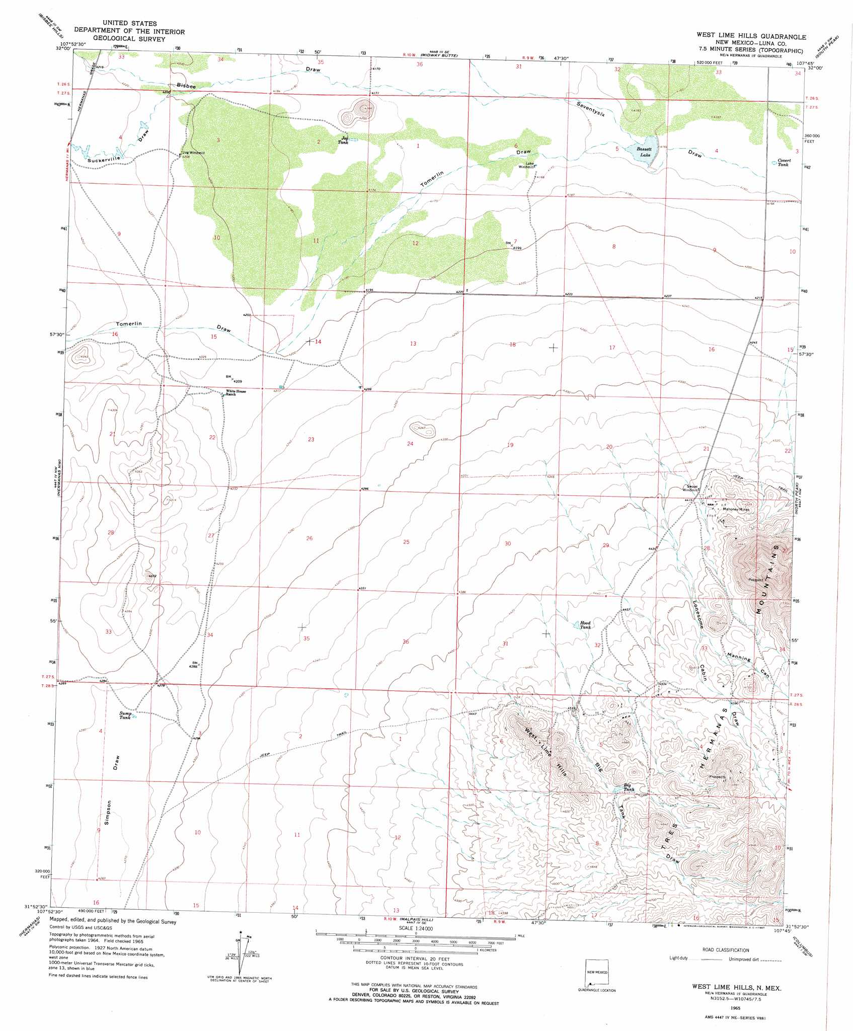
USGS Topo Quad 31107h7 - 1:24,000 scale
| Topo Map Name: | West Lime Hills |
| USGS Topo Quad ID: | 31107h7 |
| Print Size: | ca. 21 1/4" wide x 27" high |
| Southeast Coordinates: | 31.875° N latitude / 107.75° W longitude |
| Map Center Coordinates: | 31.9375° N latitude / 107.8125° W longitude |
| U.S. State: | NM |
| Filename: | o31107h7.jpg |
| Download Map JPG Image: | West Lime Hills topo map 1:24,000 scale |
| Map Type: | Topographic |
| Topo Series: | 7.5´ |
| Map Scale: | 1:24,000 |
| Source of Map Images: | United States Geological Survey (USGS) |
| Alternate Map Versions: |
West Lime Hills NM 1965, updated 1967 Download PDF Buy paper map West Lime Hills NM 1965, updated 1967 Download PDF Buy paper map West Lime Hills NM 1996, updated 2002 Download PDF Buy paper map West Lime Hills NM 2010 Download PDF Buy paper map West Lime Hills NM 2013 Download PDF Buy paper map West Lime Hills NM 2017 Download PDF Buy paper map |
1:24,000 Topo Quads surrounding West Lime Hills
Gage |
Red Mountain |
Bowlin Ranch |
Capitol Dome |
Florida Gap |
Gage Se |
Bisbee Hills |
Midway Butte |
South Peak |
Gym Peak |
Flying W Mountain |
Hermanas Nw |
West Lime Hills |
North Peak |
Columbus Ne |
Victorio Ranch Se |
Hermanas |
Malpais Hill |
Columbus |
Columbus Se |
> Back to 31107e1 at 1:100,000 scale
> Back to 31106a1 at 1:250,000 scale
> Back to U.S. Topo Maps home
West Lime Hills topo map: Gazetteer
West Lime Hills: Mines
Black Hawk elevation 1411m 4629′Cincinnati elevation 1387m 4550′
Hancock elevation 1384m 4540′
Mahoney Mines elevation 1355m 4445′
Mahoney Mining Area elevation 1368m 4488′
Marie elevation 1403m 4603′
West Lime Hills: Reservoirs
Bassett Lake elevation 1269m 4163′Big Tank elevation 1394m 4573′
Covert Tank elevation 1266m 4153′
Hood Tank elevation 1357m 4452′
Jog Tank elevation 1272m 4173′
Sump Tank elevation 1304m 4278′
West Lime Hills: Summits
West Lime Hills elevation 1461m 4793′West Lime Hills: Valleys
Big Tank Draw elevation 1347m 4419′Bisbee Draw elevation 1271m 4169′
Lonesome Cabin Draw elevation 1321m 4333′
Manning Canyon elevation 1379m 4524′
Suckerville Draw elevation 1281m 4202′
Tomerlin Draw elevation 1269m 4163′
West Lime Hills: Wells
00941 Water Well elevation 1270m 4166′00942 Water Well elevation 1287m 4222′
00952 Water Well elevation 1346m 4416′
01072 Water Well elevation 1308m 4291′
01073 Water Well elevation 1307m 4288′
01076 Water Well elevation 1349m 4425′
016067 Water Well elevation 1423m 4668′
01630 Water Well elevation 1281m 4202′
01631 Water Well elevation 1292m 4238′
01632 Water Well elevation 1292m 4238′
01634 Water Well elevation 1286m 4219′
01669 Water Well elevation 1282m 4206′
05027 Water Well elevation 1299m 4261′
06042 Water Well elevation 1306m 4284′
06044 Water Well elevation 1339m 4393′
10387 Water Well elevation 1288m 4225′
10388 Water Well elevation 1286m 4219′
West Lime Hills digital topo map on disk
Buy this West Lime Hills topo map showing relief, roads, GPS coordinates and other geographical features, as a high-resolution digital map file on DVD: