Clanton Draw Topo Map New Mexico
To zoom in, hover over the map of Clanton Draw
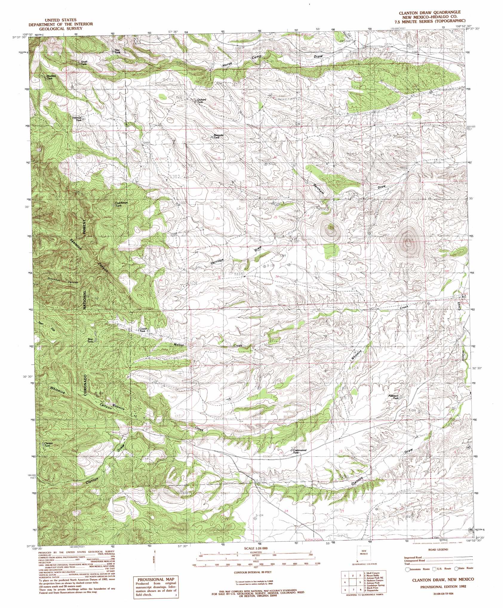
USGS Topo Quad 31108e8 - 1:24,000 scale
| Topo Map Name: | Clanton Draw |
| USGS Topo Quad ID: | 31108e8 |
| Print Size: | ca. 21 1/4" wide x 27" high |
| Southeast Coordinates: | 31.5° N latitude / 108.875° W longitude |
| Map Center Coordinates: | 31.5625° N latitude / 108.9375° W longitude |
| U.S. State: | NM |
| Filename: | o31108e8.jpg |
| Download Map JPG Image: | Clanton Draw topo map 1:24,000 scale |
| Map Type: | Topographic |
| Topo Series: | 7.5´ |
| Map Scale: | 1:24,000 |
| Source of Map Images: | United States Geological Survey (USGS) |
| Alternate Map Versions: |
Clanton Draw NM 1982, updated 1982 Download PDF Buy paper map Clanton Draw NM 1982, updated 1982 Download PDF Buy paper map Clanton Draw NM 1998, updated 2003 Download PDF Buy paper map Clanton Draw NM 2012 Download PDF Buy paper map Clanton Draw NM 2013 Download PDF Buy paper map |
| FStopo: | US Forest Service topo Clanton Draw is available: Download FStopo PDF Download FStopo TIF |
1:24,000 Topo Quads surrounding Clanton Draw
Portal Peak |
Rodeo |
Indian Peak |
Tank Mountain |
Whitmire Pass |
Apache |
Skull Canyon |
Mount Baldy |
Animas Peak Ne |
Gillespie Mountain |
Paramore Crater |
Skeleton Canyon |
Clanton Draw |
Animas Peak |
Center Peak |
Lazy J Ranch |
Guadalupe Spring |
Black Point |
Fitzpatricks |
San Luis Pass |
West Of Guadalupe Canyon |
Guadalupe Canyon |
Guadalupe Pass |
Lang Canyon |
Whitewater Creek |
> Back to 31108e1 at 1:100,000 scale
> Back to 31108a1 at 1:250,000 scale
> Back to U.S. Topo Maps home
Clanton Draw topo map: Gazetteer
Clanton Draw: Arroyos
Herridge Draw elevation 1563m 5127′Clanton Draw: Reservoirs
Bow Tank elevation 1658m 5439′Clanton Tank elevation 1699m 5574′
Cottonwood Tank elevation 1611m 5285′
Cowan Tank elevation 1633m 5357′
Dutchman Tank elevation 1678m 5505′
Irishman Tank elevation 1702m 5583′
Maddox Tank elevation 1757m 5764′
Mesquite Tank elevation 1636m 5367′
New Tank elevation 1693m 5554′
Orchard Tank elevation 1644m 5393′
Patterson Tank elevation 1575m 5167′
South Tank elevation 1730m 5675′
Clanton Draw: Streams
Walnut Creek elevation 1533m 5029′Whitmire Creek elevation 1533m 5029′
Clanton Draw: Valleys
Bercham Draw elevation 1522m 4993′Clanton Draw elevation 1549m 5082′
Cox Canyon elevation 1560m 5118′
Dutchman Canyon elevation 1624m 5328′
Last Chance Draw elevation 1536m 5039′
Whitmire Canyon elevation 1551m 5088′
Clanton Draw digital topo map on disk
Buy this Clanton Draw topo map showing relief, roads, GPS coordinates and other geographical features, as a high-resolution digital map file on DVD: