Pedregosa Mountains West Topo Map Arizona
To zoom in, hover over the map of Pedregosa Mountains West
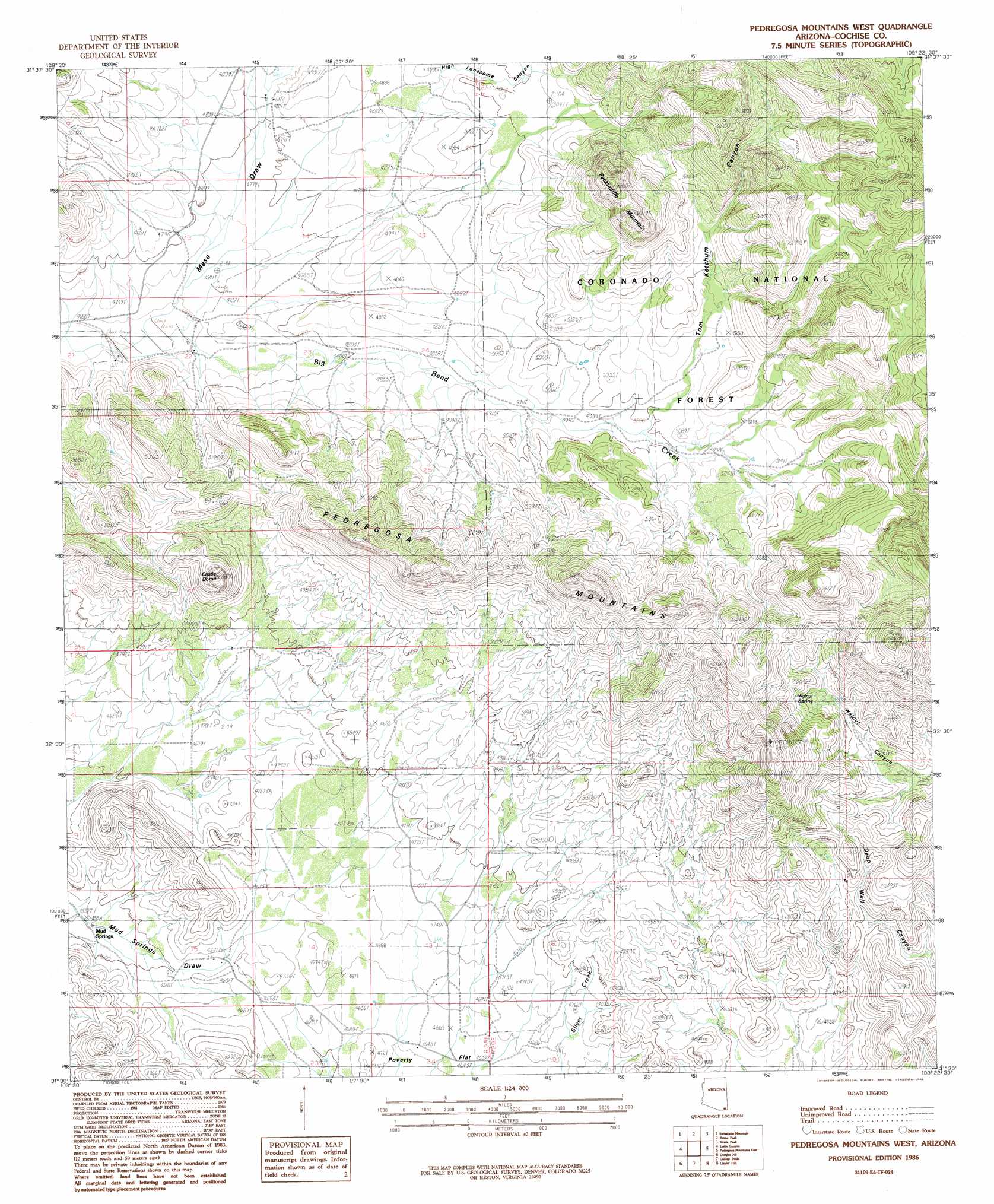
USGS Topo Quad 31109e4 - 1:24,000 scale
| Topo Map Name: | Pedregosa Mountains West |
| USGS Topo Quad ID: | 31109e4 |
| Print Size: | ca. 21 1/4" wide x 27" high |
| Southeast Coordinates: | 31.5° N latitude / 109.375° W longitude |
| Map Center Coordinates: | 31.5625° N latitude / 109.4375° W longitude |
| U.S. State: | AZ |
| Filename: | o31109e4.jpg |
| Download Map JPG Image: | Pedregosa Mountains West topo map 1:24,000 scale |
| Map Type: | Topographic |
| Topo Series: | 7.5´ |
| Map Scale: | 1:24,000 |
| Source of Map Images: | United States Geological Survey (USGS) |
| Alternate Map Versions: |
Pedregosa Mountains West AZ 1986, updated 1986 Download PDF Buy paper map Pedregosa Mountains West AZ 1986, updated 1986 Download PDF Buy paper map Pedregosa Mountains West AZ 1996, updated 2003 Download PDF Buy paper map Pedregosa Mountains West AZ 2012 Download PDF Buy paper map Pedregosa Mountains West AZ 2014 Download PDF Buy paper map |
| FStopo: | US Forest Service topo Pedregosa Mountains West is available: Download FStopo PDF Download FStopo TIF |
1:24,000 Topo Quads surrounding Pedregosa Mountains West
Squaretop Hills West |
Squaretop Hills East |
Stanford Canyon |
Chiricahua Peak |
Portal Peak |
Elfrida |
Swisshelm Mountain |
Bruno Peak |
Swede Peak |
Apache |
Mcneal |
Leslie Canyon |
Pedregosa Mountains West |
Pedregosa Mountains East |
Paramore Crater |
Double Adobe |
Douglas Ne |
College Peaks |
Cinder Hill |
Lazy J Ranch |
Paul Spur |
Douglas |
East Of Douglas |
San Bernardino Ranch |
West Of Guadalupe Canyon |
> Back to 31109e1 at 1:100,000 scale
> Back to 31108a1 at 1:250,000 scale
> Back to U.S. Topo Maps home
Pedregosa Mountains West topo map: Gazetteer
Pedregosa Mountains West: Ranges
Pedregosa Mountains elevation 1758m 5767′Pedregosa Mountains West: Reservoirs
Big Bend Number One Tank elevation 1551m 5088′Big Bend Number Two Tank elevation 1508m 4947′
High Lonesome Tank elevation 1519m 4983′
Houston Tank elevation 1750m 5741′
Hunsaker Tank elevation 1521m 4990′
Limestone Tank elevation 1589m 5213′
Tom Ketchum Tank elevation 1726m 5662′
Upper Seep Tank elevation 1512m 4960′
Pedregosa Mountains West: Springs
Mud Springs elevation 1391m 4563′Walnut Spring elevation 1694m 5557′
Pedregosa Mountains West: Streams
Big Bend Creek elevation 1433m 4701′Pedregosa Mountains West: Summits
Castle Dome elevation 1763m 5784′Packsaddle Mountain elevation 1921m 6302′
Pedregosa Mountains West: Valleys
Box Canyon elevation 1473m 4832′Hale Canyon elevation 1487m 4878′
High Lonesome Canyon elevation 1452m 4763′
Mesa Draw elevation 1436m 4711′
Tom Ketchum Canyon elevation 1542m 5059′
Pedregosa Mountains West digital topo map on disk
Buy this Pedregosa Mountains West topo map showing relief, roads, GPS coordinates and other geographical features, as a high-resolution digital map file on DVD: