Apache Topo Map Arizona
To zoom in, hover over the map of Apache
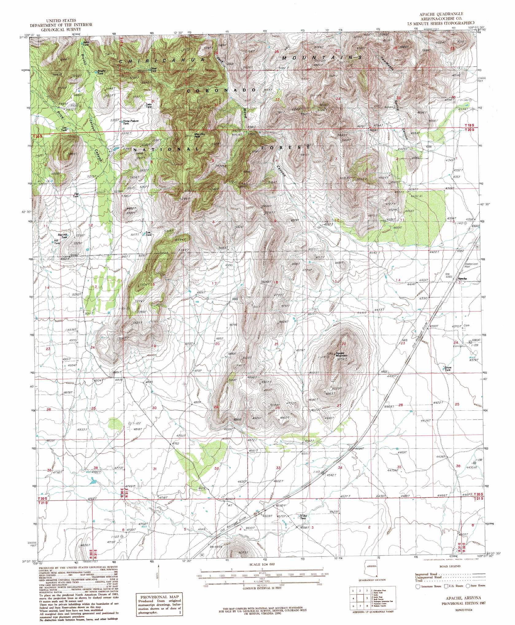
USGS Topo Quad 31109f2 - 1:24,000 scale
| Topo Map Name: | Apache |
| USGS Topo Quad ID: | 31109f2 |
| Print Size: | ca. 21 1/4" wide x 27" high |
| Southeast Coordinates: | 31.625° N latitude / 109.125° W longitude |
| Map Center Coordinates: | 31.6875° N latitude / 109.1875° W longitude |
| U.S. State: | AZ |
| Filename: | o31109f2.jpg |
| Download Map JPG Image: | Apache topo map 1:24,000 scale |
| Map Type: | Topographic |
| Topo Series: | 7.5´ |
| Map Scale: | 1:24,000 |
| Source of Map Images: | United States Geological Survey (USGS) |
| Alternate Map Versions: |
Apache AZ 1987, updated 1987 Download PDF Buy paper map Apache AZ 1996, updated 2003 Download PDF Buy paper map Apache AZ 2012 Download PDF Buy paper map Apache AZ 2014 Download PDF Buy paper map |
| FStopo: | US Forest Service topo Apache is available: Download FStopo PDF Download FStopo TIF |
1:24,000 Topo Quads surrounding Apache
Fife Peak |
Rustler Park |
Portal |
Portal Ne |
Antelope Pass |
Stanford Canyon |
Chiricahua Peak |
Portal Peak |
Rodeo |
Indian Peak |
Bruno Peak |
Swede Peak |
Apache |
Skull Canyon |
Mount Baldy |
Pedregosa Mountains West |
Pedregosa Mountains East |
Paramore Crater |
Skeleton Canyon |
Clanton Draw |
College Peaks |
Cinder Hill |
Lazy J Ranch |
Guadalupe Spring |
Black Point |
> Back to 31109e1 at 1:100,000 scale
> Back to 31108a1 at 1:250,000 scale
> Back to U.S. Topo Maps home
Apache topo map: Gazetteer
Apache: Parks
Geronimo Surrender Monument elevation 1333m 4373′Apache: Populated Places
Apache elevation 1336m 4383′Apache: Reservoirs
Brushy Tank elevation 1684m 5524′Dirt Tank elevation 1650m 5413′
East Tank elevation 1576m 5170′
Flat Tank elevation 1599m 5246′
Forest Boundary Tank elevation 1569m 5147′
Glass Tank elevation 1615m 5298′
Hill Tank elevation 1574m 5164′
Horse Pasture Tank elevation 1633m 5357′
IV Bar Tank elevation 1391m 4563′
Jacks Tank elevation 1699m 5574′
Kambitsch Tank elevation 1594m 5229′
Latta Tank elevation 1672m 5485′
Red Hill Tank elevation 1611m 5285′
Snure Tank elevation 1343m 4406′
Warner Storage Tank elevation 1676m 5498′
Apache: Summits
May Day Peak elevation 1927m 6322′Squaw Mountain elevation 1600m 5249′
Apache: Valleys
Brushy Canyon elevation 1597m 5239′Jack Wood Canyon elevation 1402m 4599′
Price Canyon elevation 1541m 5055′
Twoweeks Spring Canyon elevation 1341m 4399′
Apache digital topo map on disk
Buy this Apache topo map showing relief, roads, GPS coordinates and other geographical features, as a high-resolution digital map file on DVD: