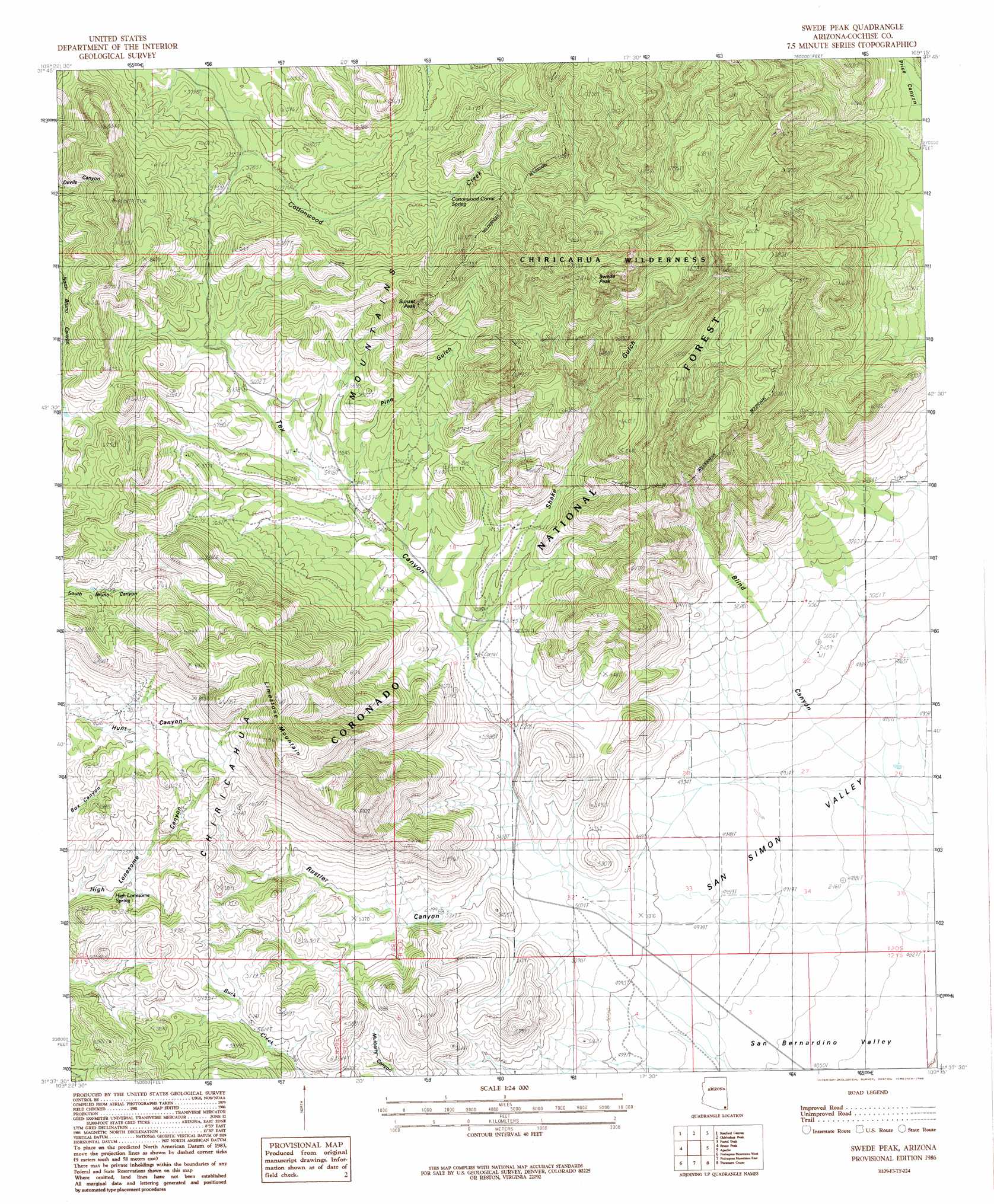
Swede Peak Topo Map Arizona
To zoom in, hover over the map of Swede Peak
USGS Topo Quad 31109f3 - 1:24,000 scale
| Topo Map Name: | Swede Peak |
| USGS Topo Quad ID: | 31109f3 |
| Print Size: | ca. 21 1/4" wide x 27" high |
| Southeast Coordinates: | 31.625° N latitude / 109.25° W longitude |
| Map Center Coordinates: | 31.6875° N latitude / 109.3125° W longitude |
| U.S. State: | AZ |
| Filename: | o31109f3.jpg |
| Download Map JPG Image: | Swede Peak topo map 1:24,000 scale |
| Map Type: | Topographic |
| Topo Series: | 7.5´ |
| Map Scale: | 1:24,000 |
| Source of Map Images: | United States Geological Survey (USGS) |
| Alternate Map Versions: |
Swede Peak AZ 1986, updated 1986 Download PDF Buy paper map Swede Peak AZ 1986, updated 1986 Download PDF Buy paper map Swede Peak AZ 1996, updated 2003 Download PDF Buy paper map Swede Peak AZ 2012 Download PDF Buy paper map Swede Peak AZ 2014 Download PDF Buy paper map |
| FStopo: | US Forest Service topo Swede Peak is available: Download FStopo PDF Download FStopo TIF |
1:24,000 Topo Quads surrounding Swede Peak
Pat Hills South |
Fife Peak |
Rustler Park |
Portal |
Portal Ne |
Squaretop Hills East |
Stanford Canyon |
Chiricahua Peak |
Portal Peak |
Rodeo |
Swisshelm Mountain |
Bruno Peak |
Swede Peak |
Apache |
Skull Canyon |
Leslie Canyon |
Pedregosa Mountains West |
Pedregosa Mountains East |
Paramore Crater |
Skeleton Canyon |
Douglas Ne |
College Peaks |
Cinder Hill |
Lazy J Ranch |
Guadalupe Spring |
> Back to 31109e1 at 1:100,000 scale
> Back to 31108a1 at 1:250,000 scale
> Back to U.S. Topo Maps home
Swede Peak topo map: Gazetteer
Swede Peak: Reservoirs
Coal Pit Tank elevation 1816m 5958′Cottonwood Tank elevation 1890m 6200′
Divil Tank elevation 1702m 5583′
Division Tank elevation 1773m 5816′
Hill Tank elevation 1680m 5511′
Joe Tank elevation 1682m 5518′
Juniper Tree Tank elevation 1779m 5836′
Limestone Tank elevation 1797m 5895′
Sunset Tank elevation 1740m 5708′
Sunset Tank elevation 1781m 5843′
Upper Bruno Tank elevation 1809m 5935′
Upper Tex Tank elevation 1753m 5751′
Swede Peak: Springs
Cottonwood Corral Spring elevation 1837m 6026′High Lonesome Spring elevation 1715m 5626′
Saner Spring elevation 0m 0′
Swede Peak: Summits
Limestone Mountain elevation 2183m 7162′Sunset Peak elevation 2142m 7027′
Swede Peak elevation 2281m 7483′
Swede Peak: Trails
Cottonwood Circle Two Hundred Thirtythree elevation 1789m 5869′Price Shake Pine Gulch Trail 235-236 elevation 2092m 6863′
Swede Peak: Valleys
Blind Canyon elevation 1476m 4842′Pine Gulch elevation 1659m 5442′
Rustler Canyon elevation 0m 0′
Shake Gulch elevation 0m 0′
Tex Canyon elevation 1558m 5111′
Swede Peak digital topo map on disk
Buy this Swede Peak topo map showing relief, roads, GPS coordinates and other geographical features, as a high-resolution digital map file on DVD: