Mustang Mountains Topo Map Arizona
To zoom in, hover over the map of Mustang Mountains
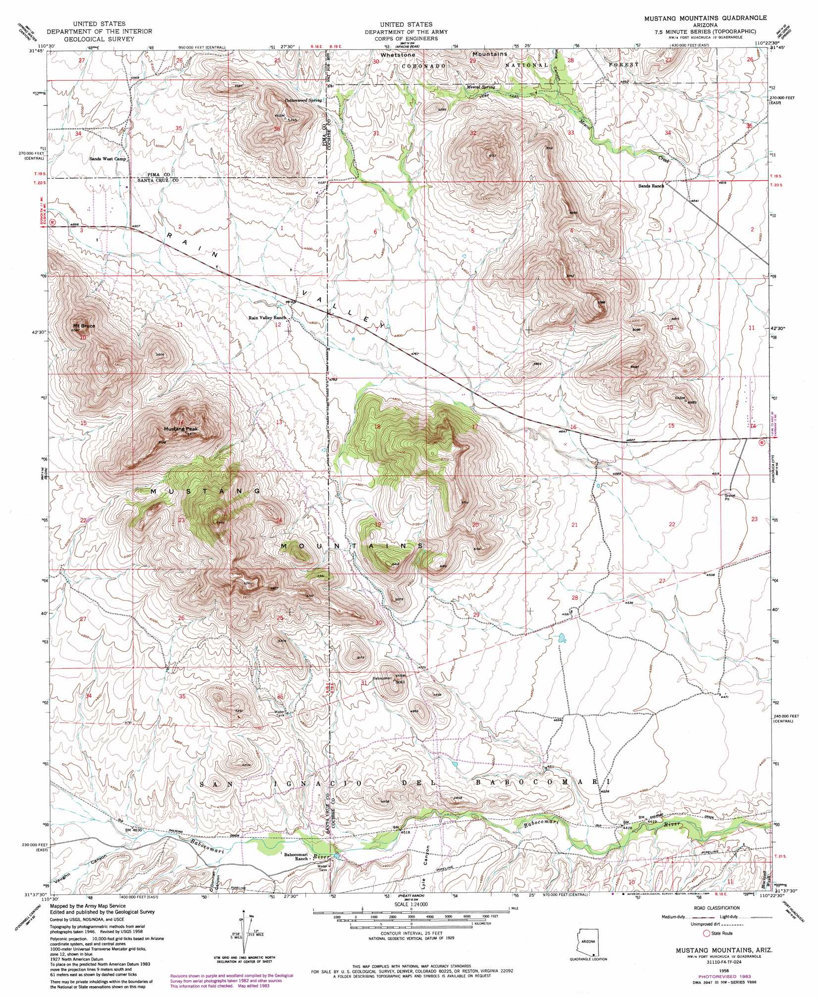
USGS Topo Quad 31110f4 - 1:24,000 scale
| Topo Map Name: | Mustang Mountains |
| USGS Topo Quad ID: | 31110f4 |
| Print Size: | ca. 21 1/4" wide x 27" high |
| Southeast Coordinates: | 31.625° N latitude / 110.375° W longitude |
| Map Center Coordinates: | 31.6875° N latitude / 110.4375° W longitude |
| U.S. State: | AZ |
| Filename: | o31110f4.jpg |
| Download Map JPG Image: | Mustang Mountains topo map 1:24,000 scale |
| Map Type: | Topographic |
| Topo Series: | 7.5´ |
| Map Scale: | 1:24,000 |
| Source of Map Images: | United States Geological Survey (USGS) |
| Alternate Map Versions: |
Mustang Mountains AZ 1948, updated 1953 Download PDF Buy paper map Mustang Mountains AZ 1958, updated 1959 Download PDF Buy paper map Mustang Mountains AZ 1958, updated 1963 Download PDF Buy paper map Mustang Mountains AZ 1958, updated 1984 Download PDF Buy paper map Mustang Mountains AZ 1996, updated 2002 Download PDF Buy paper map Mustang Mountains AZ 2012 Download PDF Buy paper map Mustang Mountains AZ 2014 Download PDF Buy paper map |
| FStopo: | US Forest Service topo Mustang Mountains is available: Download FStopo PDF Download FStopo TIF |
1:24,000 Topo Quads surrounding Mustang Mountains
Mount Fagan |
The Narrows |
Mescal |
Benson |
Saint David |
Empire Ranch |
Spring Water Canyon |
Apache Peak |
Mcgrew Spring |
Land |
Sonoita |
Elgin |
Mustang Mountains |
Huachuca City |
Fairbank |
Mount Hughes |
O'Donnel Canyon |
Pyeatt Ranch |
Fort Huachuca |
Lewis Springs |
Harshaw |
Canelo Pass |
Huachuca Peak |
Miller Peak |
Nicksville |
> Back to 31110e1 at 1:100,000 scale
> Back to 31110a1 at 1:250,000 scale
> Back to U.S. Topo Maps home
Mustang Mountains topo map: Gazetteer
Mustang Mountains: Springs
Cottonwood Spring elevation 1569m 5147′Mescal Spring elevation 1544m 5065′
T 4 Springs elevation 1413m 4635′
Mustang Mountains: Summits
Mount Bruce elevation 1812m 5944′Mustang Mountains elevation 1862m 6108′
Mustang Peak elevation 1914m 6279′
North West Dome elevation 1873m 6145′
Mustang Mountains: Valleys
Lyle Canyon elevation 1377m 4517′Mine Canyon elevation 1486m 4875′
O'Donnell Canyon elevation 1401m 4596′
Rain Valley elevation 1394m 4573′
Vaughn Canyon elevation 1407m 4616′
Mustang Mountains digital topo map on disk
Buy this Mustang Mountains topo map showing relief, roads, GPS coordinates and other geographical features, as a high-resolution digital map file on DVD: