Mount Hopkins Topo Map Arizona
To zoom in, hover over the map of Mount Hopkins
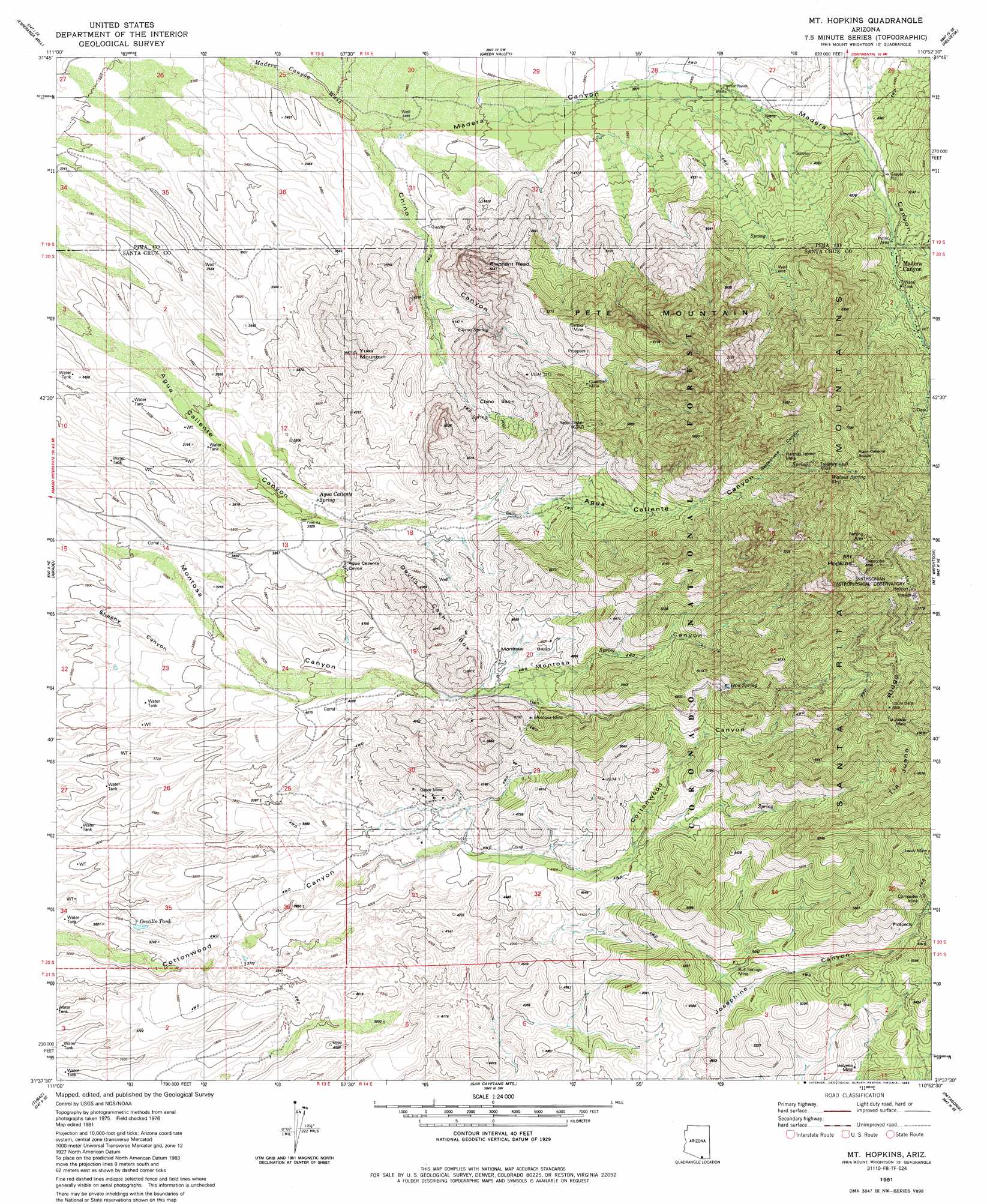
USGS Topo Quad 31110f8 - 1:24,000 scale
| Topo Map Name: | Mount Hopkins |
| USGS Topo Quad ID: | 31110f8 |
| Print Size: | ca. 21 1/4" wide x 27" high |
| Southeast Coordinates: | 31.625° N latitude / 110.875° W longitude |
| Map Center Coordinates: | 31.6875° N latitude / 110.9375° W longitude |
| U.S. State: | AZ |
| Filename: | o31110f8.jpg |
| Download Map JPG Image: | Mount Hopkins topo map 1:24,000 scale |
| Map Type: | Topographic |
| Topo Series: | 7.5´ |
| Map Scale: | 1:24,000 |
| Source of Map Images: | United States Geological Survey (USGS) |
| Alternate Map Versions: |
Mt. Hopkins AZ 1981, updated 1981 Download PDF Buy paper map Mt. Hopkins AZ 1981, updated 1986 Download PDF Buy paper map Mt. Hopkins AZ 1981, updated 1986 Download PDF Buy paper map Mount Hopkins AZ 1996, updated 2002 Download PDF Buy paper map Mount Hopkins AZ 2012 Download PDF Buy paper map Mount Hopkins AZ 2014 Download PDF Buy paper map |
| FStopo: | US Forest Service topo Mount Hopkins is available: Download FStopo PDF Download FStopo TIF |
1:24,000 Topo Quads surrounding Mount Hopkins
Samaniego Peak |
Twin Buttes |
Sahuarita |
Corona De Tucson |
Mount Fagan |
Batamote Hills |
Esperanza Mill |
Green Valley |
Helvetia |
Empire Ranch |
Saucito Mountain |
Amado |
Mount Hopkins |
Mount Wrightson |
Sonoita |
Murphy Peak |
Tubac |
San Cayetano Mountains |
Patagonia |
Mount Hughes |
Ruby |
Pena Blanca Lake |
Rio Rico |
Cumero Canyon |
Harshaw |
> Back to 31110e1 at 1:100,000 scale
> Back to 31110a1 at 1:250,000 scale
> Back to U.S. Topo Maps home
Mount Hopkins topo map: Gazetteer
Mount Hopkins: Basins
Chino Basin elevation 1264m 4146′Montosa Basin elevation 1392m 4566′
Mount Hopkins: Gaps
Agua Caliente Saddle elevation 2213m 7260′Mount Hopkins: Mines
Bull Springs Mine elevation 1454m 4770′Compadre Mine elevation 1596m 5236′
Eureka Mine elevation 1711m 5613′
Glove Mine elevation 1293m 4242′
Helvetia Mine elevation 1461m 4793′
Hermits Home Mine elevation 1940m 6364′
Leroy Mine elevation 1696m 5564′
Montosa Mine elevation 1513m 4963′
Quantrell Mine elevation 1581m 5187′
Treasure Vault Mine elevation 2065m 6774′
Mount Hopkins: Populated Places
Madera Canyon elevation 1497m 4911′Mount Hopkins: Reservoirs
Bergier Tank elevation 1428m 4685′Ocotillo Tank elevation 1102m 3615′
Mount Hopkins: Ridges
Devils Cash Box elevation 1741m 5711′Tia Juana Ridge elevation 2036m 6679′
Mount Hopkins: Springs
Agua Caliente Spring elevation 1189m 3900′Chino Spring elevation 1279m 4196′
Chino Spring Number Two elevation 1268m 4160′
Iron Spring elevation 1741m 5711′
Walnut Spring elevation 2064m 6771′
Walnut Spring elevation 1968m 6456′
Mount Hopkins: Summits
Elephant Head elevation 1709m 5606′Mount Hopkins elevation 2576m 8451′
Pete Mountain elevation 2307m 7568′
Yoas Mountain elevation 1337m 4386′
Mount Hopkins: Trails
Josephine Saddle Madera Trail Number 134 elevation 1603m 5259′Vault Mine Trail One Hundred Forty elevation 1923m 6309′
Mount Hopkins: Valleys
Chino Canyon elevation 1063m 3487′Madera Canyon elevation 1086m 3562′
Rattlesnake Canyon elevation 1610m 5282′
Mount Hopkins digital topo map on disk
Buy this Mount Hopkins topo map showing relief, roads, GPS coordinates and other geographical features, as a high-resolution digital map file on DVD: