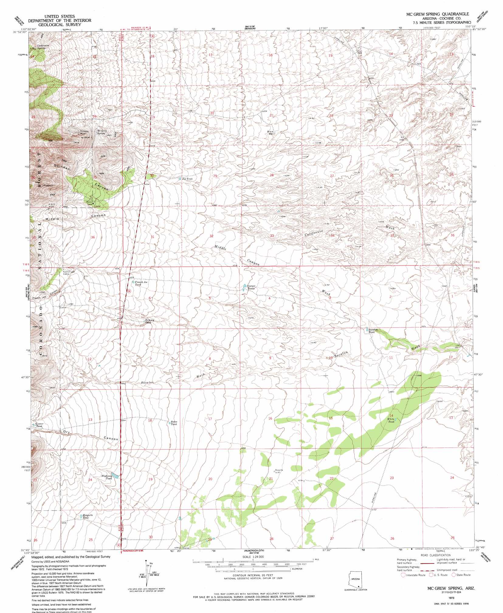
Mcgrew Spring Topo Map Arizona
To zoom in, hover over the map of Mcgrew Spring
USGS Topo Quad 31110g3 - 1:24,000 scale
| Topo Map Name: | Mcgrew Spring |
| USGS Topo Quad ID: | 31110g3 |
| Print Size: | ca. 21 1/4" wide x 27" high |
| Southeast Coordinates: | 31.75° N latitude / 110.25° W longitude |
| Map Center Coordinates: | 31.8125° N latitude / 110.3125° W longitude |
| U.S. State: | AZ |
| Filename: | o31110g3.jpg |
| Download Map JPG Image: | Mcgrew Spring topo map 1:24,000 scale |
| Map Type: | Topographic |
| Topo Series: | 7.5´ |
| Map Scale: | 1:24,000 |
| Source of Map Images: | United States Geological Survey (USGS) |
| Alternate Map Versions: |
McGrew Spring AZ 1973, updated 1976 Download PDF Buy paper map Mc Grew Spring AZ 1973, updated 1992 Download PDF Buy paper map Mc Grew Spring AZ 1996, updated 2002 Download PDF Buy paper map McGrew Spring AZ 2012 Download PDF Buy paper map McGrew Spring AZ 2014 Download PDF Buy paper map |
| FStopo: | US Forest Service topo McGrew Spring is available: Download FStopo PDF Download FStopo TIF |
1:24,000 Topo Quads surrounding Mcgrew Spring
Rincon Peak |
Galleta Flat West |
Galleta Flat East |
San Pedro Ranch |
Dragoon |
The Narrows |
Mescal |
Benson |
Saint David |
Knob Hill |
Spring Water Canyon |
Apache Peak |
Mcgrew Spring |
Land |
Haberstock Hill |
Elgin |
Mustang Mountains |
Huachuca City |
Fairbank |
Tombstone |
O'Donnel Canyon |
Pyeatt Ranch |
Fort Huachuca |
Lewis Springs |
Tombstone Se |
> Back to 31110e1 at 1:100,000 scale
> Back to 31110a1 at 1:250,000 scale
> Back to U.S. Topo Maps home
Mcgrew Spring topo map: Gazetteer
Mcgrew Spring: Mines
H Mine elevation 1502m 4927′Lone Star Mine elevation 1517m 4977′
Ricketts Mine elevation 1570m 5150′
Mcgrew Spring: Parks
Kartchner Caverns State Park elevation 1443m 4734′Mcgrew Spring: Reservoirs
Bates Tank elevation 1339m 4393′Corner Tanks elevation 1312m 4304′
French Joe Tank elevation 1389m 4557′
Highway Tank elevation 1370m 4494′
Jog Tank elevation 1353m 4438′
Lower Tank elevation 1466m 4809′
Mesquite Tank elevation 1369m 4491′
Ramsey Tank elevation 1379m 4524′
Sacaton Tank elevation 1232m 4041′
White Tank elevation 1234m 4048′
Mcgrew Spring: Springs
Castanera Spring elevation 1575m 5167′Dry Canyon Spring elevation 1422m 4665′
McGrew Spring elevation 1463m 4799′
Mcgrew Spring: Streams
Middle Canyon Wash elevation 1219m 3999′Mcgrew Spring: Valleys
Dry Canyon elevation 1348m 4422′French Joe Canyon elevation 1324m 4343′
Guindani Canyon elevation 1379m 4524′
Middle Canyon elevation 1219m 3999′
Mcgrew Spring: Wells
Black Well elevation 1286m 4219′Mcgrew Spring digital topo map on disk
Buy this Mcgrew Spring topo map showing relief, roads, GPS coordinates and other geographical features, as a high-resolution digital map file on DVD: