Spring Water Canyon Topo Map Arizona
To zoom in, hover over the map of Spring Water Canyon
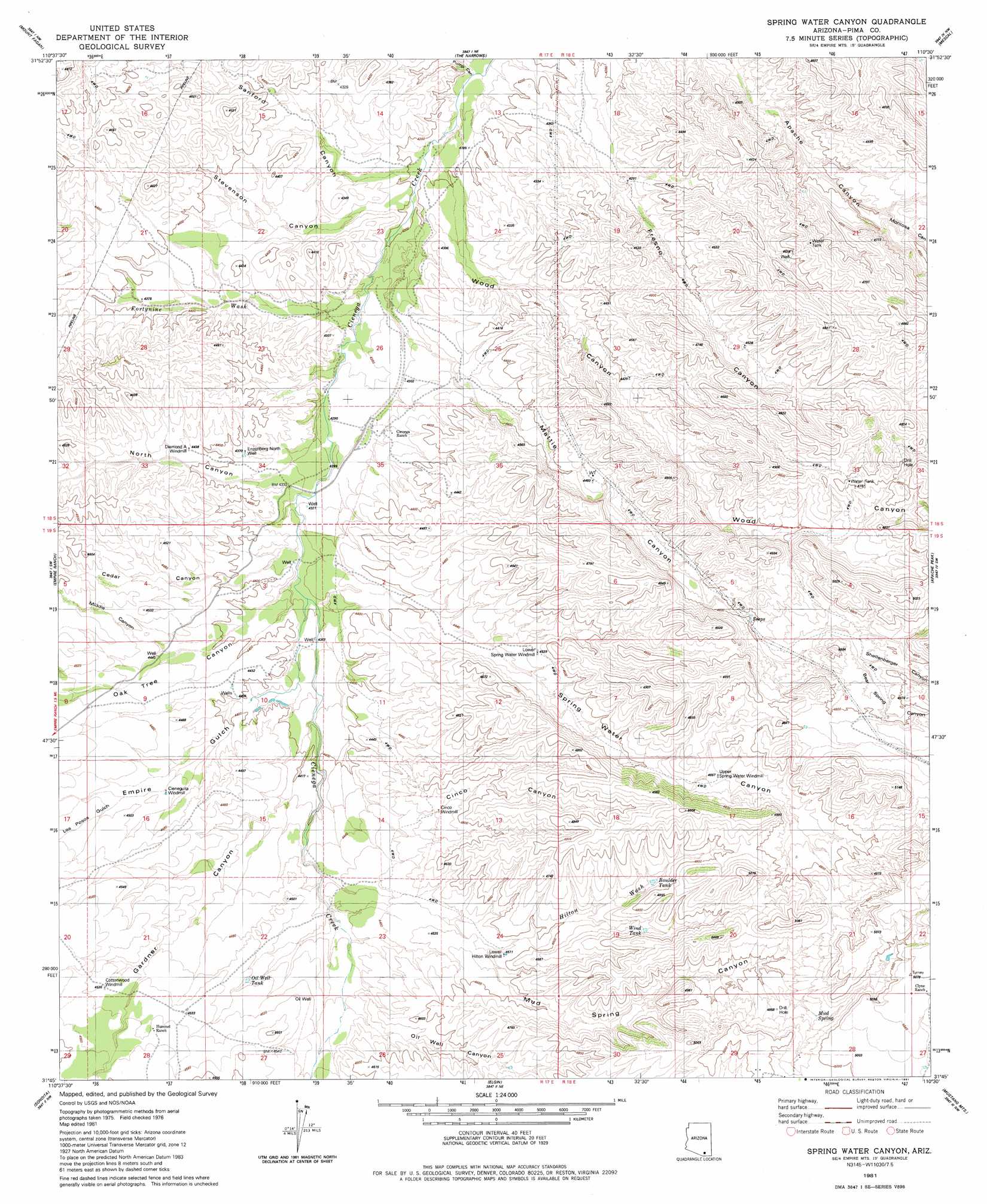
USGS Topo Quad 31110g5 - 1:24,000 scale
| Topo Map Name: | Spring Water Canyon |
| USGS Topo Quad ID: | 31110g5 |
| Print Size: | ca. 21 1/4" wide x 27" high |
| Southeast Coordinates: | 31.75° N latitude / 110.5° W longitude |
| Map Center Coordinates: | 31.8125° N latitude / 110.5625° W longitude |
| U.S. State: | AZ |
| Filename: | o31110g5.jpg |
| Download Map JPG Image: | Spring Water Canyon topo map 1:24,000 scale |
| Map Type: | Topographic |
| Topo Series: | 7.5´ |
| Map Scale: | 1:24,000 |
| Source of Map Images: | United States Geological Survey (USGS) |
| Alternate Map Versions: |
Spring Water Canyon AZ 1981, updated 1981 Download PDF Buy paper map Spring Water Canyon AZ 1981, updated 1981 Download PDF Buy paper map Spring Water Canyon AZ 1996, updated 2002 Download PDF Buy paper map Spring Water Canyon AZ 2012 Download PDF Buy paper map Spring Water Canyon AZ 2014 Download PDF Buy paper map |
| FStopo: | US Forest Service topo Spring Water Canyon is available: Download FStopo PDF Download FStopo TIF |
1:24,000 Topo Quads surrounding Spring Water Canyon
Tucson Se |
Vail |
Rincon Peak |
Galleta Flat West |
Galleta Flat East |
Corona De Tucson |
Mount Fagan |
The Narrows |
Mescal |
Benson |
Helvetia |
Empire Ranch |
Spring Water Canyon |
Apache Peak |
Mcgrew Spring |
Mount Wrightson |
Sonoita |
Elgin |
Mustang Mountains |
Huachuca City |
Patagonia |
Mount Hughes |
O'Donnel Canyon |
Pyeatt Ranch |
Fort Huachuca |
> Back to 31110e1 at 1:100,000 scale
> Back to 31110a1 at 1:250,000 scale
> Back to U.S. Topo Maps home
Spring Water Canyon topo map: Gazetteer
Spring Water Canyon: Reservoirs
Boulder Tank elevation 1435m 4708′Oil Well Tank elevation 1372m 4501′
Wind Tank elevation 1437m 4714′
Spring Water Canyon: Springs
Mud Spring elevation 1476m 4842′Spring Water Canyon: Streams
Fortynine Wash elevation 1304m 4278′Hilton Wash elevation 1388m 4553′
Spring Water Canyon: Valleys
Bear Spring Canyon elevation 1438m 4717′Cedar Canyon elevation 1330m 4363′
Cinco Canyon elevation 1342m 4402′
Empire Gulch elevation 1336m 4383′
Gardner Canyon elevation 1342m 4402′
Greaterville Gulch elevation 1373m 4504′
Los Posos Gulch elevation 1364m 4475′
Los Posos Gulch elevation 1364m 4475′
Mattie Canyon elevation 1315m 4314′
Middle Canyon elevation 1352m 4435′
Montosa Canyon elevation 1352m 4435′
Mud Spring Canyon elevation 1367m 4484′
North Canyon elevation 1325m 4347′
Oak Tree Canyon elevation 1332m 4370′
Oil Well Canyon elevation 1373m 4504′
Sanford Canyon elevation 1280m 4199′
Shellenberger Canyon elevation 1438m 4717′
Spring Water Canyon elevation 1330m 4363′
Stevenson Canyon elevation 1284m 4212′
Wood Canyon elevation 1291m 4235′
Spring Water Canyon: Wells
Cieneguita Windmill elevation 1360m 4461′Cinco Windmill elevation 1377m 4517′
Diamond A Windmill elevation 1352m 4435′
Enzenberg North Well elevation 1331m 4366′
Lower Hilton Windmill elevation 1392m 4566′
Lower Spring Water Windmill elevation 1385m 4543′
Upper Spring Water Windmill elevation 1423m 4668′
Spring Water Canyon digital topo map on disk
Buy this Spring Water Canyon topo map showing relief, roads, GPS coordinates and other geographical features, as a high-resolution digital map file on DVD: