Wilbur Canyon Topo Map Arizona
To zoom in, hover over the map of Wilbur Canyon
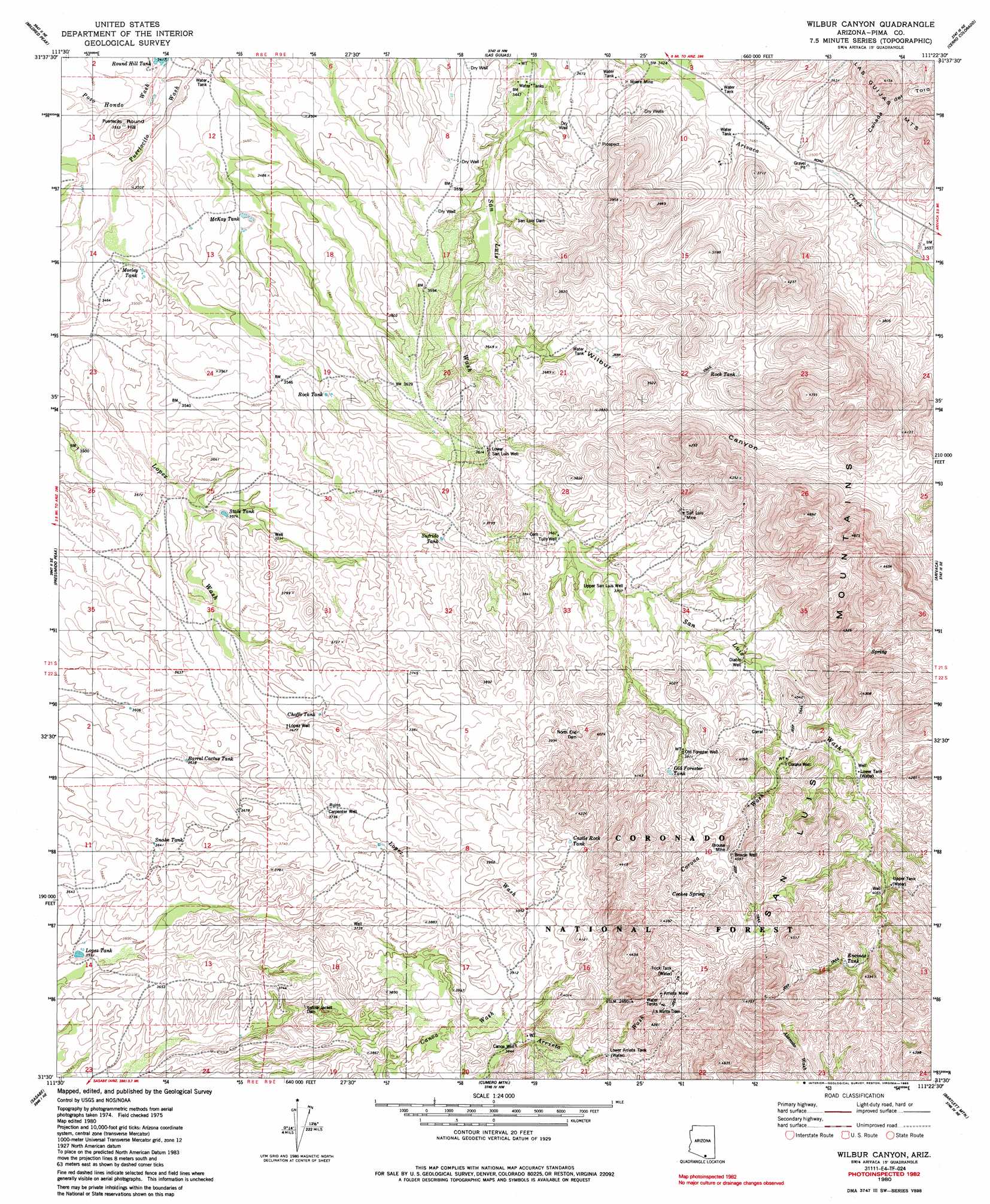
USGS Topo Quad 31111e4 - 1:24,000 scale
| Topo Map Name: | Wilbur Canyon |
| USGS Topo Quad ID: | 31111e4 |
| Print Size: | ca. 21 1/4" wide x 27" high |
| Southeast Coordinates: | 31.5° N latitude / 111.375° W longitude |
| Map Center Coordinates: | 31.5625° N latitude / 111.4375° W longitude |
| U.S. State: | AZ |
| Filename: | o31111e4.jpg |
| Download Map JPG Image: | Wilbur Canyon topo map 1:24,000 scale |
| Map Type: | Topographic |
| Topo Series: | 7.5´ |
| Map Scale: | 1:24,000 |
| Source of Map Images: | United States Geological Survey (USGS) |
| Alternate Map Versions: |
Wilbur Canyon AZ 1980, updated 1980 Download PDF Buy paper map Wilbur Canyon AZ 1980, updated 1985 Download PDF Buy paper map Wilbur Canyon AZ 1980, updated 1985 Download PDF Buy paper map Wilbur Canyon AZ 1996, updated 2002 Download PDF Buy paper map Wilbur Canyon AZ 2012 Download PDF Buy paper map Wilbur Canyon AZ 2014 Download PDF Buy paper map |
| FStopo: | US Forest Service topo Wilbur Canyon is available: Download FStopo PDF Download FStopo TIF |
1:24,000 Topo Quads surrounding Wilbur Canyon
Chiuli Shaik |
Baboquivari Peak |
Fresno Wash |
Penitas Hills |
Batamote Hills |
Aguirre Peak |
Mildred Peak |
Las Guijas |
Cerro Colorado |
Saucito Mountain |
Caponera Peak |
Presumido Peak |
Wilbur Canyon |
Arivaca |
Murphy Peak |
Sasabe |
Cumero Mountain |
Bartlett Mountain |
Ruby |
|
Alamo Spring |
> Back to 31111e1 at 1:100,000 scale
> Back to 31110a1 at 1:250,000 scale
> Back to U.S. Topo Maps home
Wilbur Canyon topo map: Gazetteer
Wilbur Canyon: Dams
La Minta Dam elevation 1248m 4094′North End Dam elevation 1186m 3891′
San Luis Dam elevation 1075m 3526′
Yellow Jacket Dam elevation 1121m 3677′
Wilbur Canyon: Mines
Arrieta Mine elevation 1282m 4206′Brouse Mine elevation 1258m 4127′
Moore Mine elevation 1060m 3477′
San Luis Mine elevation 1166m 3825′
Wilbur Canyon: Populated Places
Puertocito elevation 1049m 3441′Wilbur Canyon: Ranges
San Luis Mountains elevation 1245m 4084′Wilbur Canyon: Reservoirs
Barrel Cactus Tank elevation 1110m 3641′Castle Rock Tank elevation 1225m 4019′
Choffo Tank elevation 1125m 3690′
Encinas Tank elevation 1283m 4209′
Lopez Tank elevation 1092m 3582′
Lower Arrieta Tank elevation 1259m 4130′
Lower Tank elevation 1206m 3956′
McKay Tank elevation 1059m 3474′
Morley Tank elevation 1056m 3464′
North End Dam Tank elevation 1186m 3891′
Old Forester Tank elevation 1205m 3953′
Rock Tank elevation 1087m 3566′
Rock Tank elevation 1140m 3740′
Snake Tank elevation 1111m 3645′
State Tank elevation 1089m 3572′
Sufrido Tank elevation 1127m 3697′
Trick Tank elevation 1293m 4242′
Upper Tank elevation 1246m 4087′
Wilbur Canyon: Springs
Agua Blanca Spring elevation 1162m 3812′Cienagita Spring elevation 1187m 3894′
Cienegita Spring elevation 1184m 3884′
Coches Spring elevation 1274m 4179′
Wilbur Canyon: Streams
Bailey Wash elevation 1050m 3444′Corona Wash elevation 1197m 3927′
Pozo Hondo Wash elevation 1042m 3418′
Wilbur Canyon: Summits
Round Hill elevation 1084m 3556′Wilbur Canyon: Valleys
Cañada del Toro elevation 1074m 3523′Wilbur Canyon elevation 1075m 3526′
Wilbur Canyon: Wells
Brouse Well elevation 1250m 4101′Canoa Well elevation 1172m 3845′
Carpenter Well elevation 1140m 3740′
Corona Well elevation 1205m 3953′
Diablo Well elevation 1158m 3799′
Lopez Well elevation 1122m 3681′
Lower San Luis Well elevation 1102m 3615′
Old Forester Well elevation 1193m 3914′
Resta Well elevation 1279m 4196′
San Luis Well elevation 1133m 3717′
Tully Well elevation 1117m 3664′
Upper San Luis Well elevation 1133m 3717′
Upper Well elevation 1240m 4068′
Wilbur Canyon digital topo map on disk
Buy this Wilbur Canyon topo map showing relief, roads, GPS coordinates and other geographical features, as a high-resolution digital map file on DVD: