Saucito Mountain Topo Map Arizona
To zoom in, hover over the map of Saucito Mountain
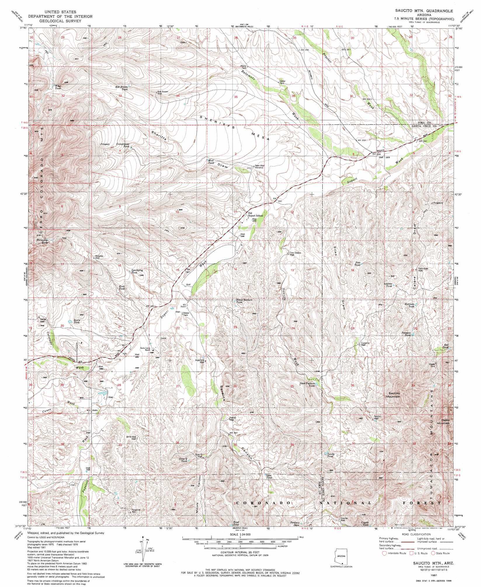
USGS Topo Quad 31111f2 - 1:24,000 scale
| Topo Map Name: | Saucito Mountain |
| USGS Topo Quad ID: | 31111f2 |
| Print Size: | ca. 21 1/4" wide x 27" high |
| Southeast Coordinates: | 31.625° N latitude / 111.125° W longitude |
| Map Center Coordinates: | 31.6875° N latitude / 111.1875° W longitude |
| U.S. State: | AZ |
| Filename: | o31111f2.jpg |
| Download Map JPG Image: | Saucito Mountain topo map 1:24,000 scale |
| Map Type: | Topographic |
| Topo Series: | 7.5´ |
| Map Scale: | 1:24,000 |
| Source of Map Images: | United States Geological Survey (USGS) |
| Alternate Map Versions: |
Saucito Mtn. AZ 1981, updated 1981 Download PDF Buy paper map Saucito Mtn. AZ 1981, updated 1981 Download PDF Buy paper map Saucito Mountain AZ 2004, updated 2006 Download PDF Buy paper map Saucito Mountain AZ 2012 Download PDF Buy paper map Saucito Mountain AZ 2014 Download PDF Buy paper map |
| FStopo: | US Forest Service topo Saucito Mountain is available: Download FStopo PDF Download FStopo TIF |
1:24,000 Topo Quads surrounding Saucito Mountain
Palo Alto Ranch |
Stevens Mountain |
Samaniego Peak |
Twin Buttes |
Sahuarita |
Fresno Wash |
Penitas Hills |
Batamote Hills |
Esperanza Mill |
Green Valley |
Las Guijas |
Cerro Colorado |
Saucito Mountain |
Amado |
Mount Hopkins |
Wilbur Canyon |
Arivaca |
Murphy Peak |
Tubac |
San Cayetano Mountains |
Cumero Mountain |
Bartlett Mountain |
Ruby |
Pena Blanca Lake |
Rio Rico |
> Back to 31111e1 at 1:100,000 scale
> Back to 31110a1 at 1:250,000 scale
> Back to U.S. Topo Maps home
Saucito Mountain topo map: Gazetteer
Saucito Mountain: Dams
Sardina Dam elevation 1129m 3704′Saucito Mountain: Reservoirs
Basin Tank elevation 1087m 3566′Bob Brown Tank elevation 1135m 3723′
Boyd Tank elevation 1151m 3776′
Compressor Tank elevation 1125m 3690′
Coyote Tank elevation 1182m 3877′
Horse Pasture Tank elevation 1059m 3474′
Horseshoe Tank elevation 1204m 3950′
Liebres Tank elevation 1077m 3533′
Line Tank elevation 1103m 3618′
Mud Tank elevation 1075m 3526′
Peñasco Tank elevation 1107m 3631′
Pete Tank elevation 1070m 3510′
Red Tank elevation 1096m 3595′
Redondo Tank elevation 1083m 3553′
Rock Tank elevation 1080m 3543′
Sandy Tank elevation 1140m 3740′
Sparkplug Tank elevation 1086m 3562′
Steer Pasture Tank elevation 1122m 3681′
Suzy Q Tank elevation 1113m 3651′
Wino Tank elevation 1188m 3897′
Saucito Mountain: Springs
Red Spring elevation 1250m 4101′Saucito Mountain: Streams
Batamote Wash elevation 1000m 3280′Canez Wash elevation 1069m 3507′
Colorado Wash elevation 1062m 3484′
Papalote Wash elevation 1061m 3480′
Proctor Wash elevation 985m 3231′
Saucito Wash elevation 1019m 3343′
Saucito Mountain: Summits
Saucito Mountain elevation 1364m 4475′Sheriffs Mesa elevation 1078m 3536′
Saucito Mountain: Valleys
Calera Draw elevation 999m 3277′Ellas Draw elevation 1009m 3310′
Moyza Canyon elevation 1084m 3556′
Sardina Canyon elevation 1046m 3431′
Sheriffs Draw elevation 1031m 3382′
Saucito Mountain: Wells
Anne Bee Well elevation 1099m 3605′Argentina Well elevation 1075m 3526′
Bob Brown Well elevation 1115m 3658′
Coyote Well elevation 1168m 3832′
Cuisanto Well elevation 1115m 3658′
Escondido Well elevation 1058m 3471′
Fresno Well elevation 1094m 3589′
Media Well elevation 1098m 3602′
New Well Windmill elevation 1050m 3444′
Papalote Alto elevation 1133m 3717′
Saucito Well elevation 1172m 3845′
Surprise Well elevation 1119m 3671′
Tres Dedos Well elevation 1048m 3438′
Saucito Mountain digital topo map on disk
Buy this Saucito Mountain topo map showing relief, roads, GPS coordinates and other geographical features, as a high-resolution digital map file on DVD: