Palo Alto Ranch Topo Map Arizona
To zoom in, hover over the map of Palo Alto Ranch
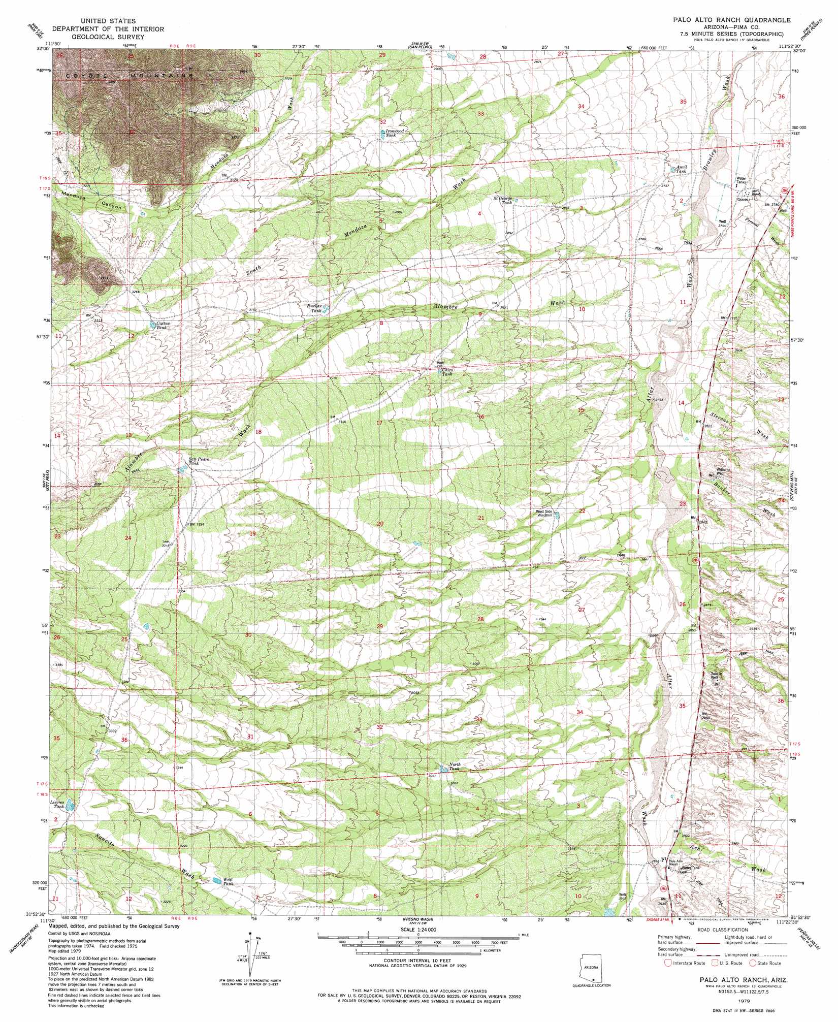
USGS Topo Quad 31111h4 - 1:24,000 scale
| Topo Map Name: | Palo Alto Ranch |
| USGS Topo Quad ID: | 31111h4 |
| Print Size: | ca. 21 1/4" wide x 27" high |
| Southeast Coordinates: | 31.875° N latitude / 111.375° W longitude |
| Map Center Coordinates: | 31.9375° N latitude / 111.4375° W longitude |
| U.S. State: | AZ |
| Filename: | o31111h4.jpg |
| Download Map JPG Image: | Palo Alto Ranch topo map 1:24,000 scale |
| Map Type: | Topographic |
| Topo Series: | 7.5´ |
| Map Scale: | 1:24,000 |
| Source of Map Images: | United States Geological Survey (USGS) |
| Alternate Map Versions: |
Palo Alto Ranch AZ 1979, updated 1979 Download PDF Buy paper map Palo Alto Ranch AZ 1979, updated 1979 Download PDF Buy paper map Palo Alto Ranch AZ 2011 Download PDF Buy paper map Palo Alto Ranch AZ 2014 Download PDF Buy paper map |
1:24,000 Topo Quads surrounding Palo Alto Ranch
Black Hills |
San Ignacio Ranch |
La Tortuga Butte |
Cocoraque Butte |
Brown Mountain |
Haivana Nakya |
Pan Tak |
San Pedro |
Three Points |
San Xavier Mission Sw |
San Juan Spring |
Kitt Peak |
Palo Alto Ranch |
Stevens Mountain |
Samaniego Peak |
Chiuli Shaik |
Baboquivari Peak |
Fresno Wash |
Penitas Hills |
Batamote Hills |
Aguirre Peak |
Mildred Peak |
Las Guijas |
Cerro Colorado |
Saucito Mountain |
> Back to 31111e1 at 1:100,000 scale
> Back to 31110a1 at 1:250,000 scale
> Back to U.S. Topo Maps home
Palo Alto Ranch topo map: Gazetteer
Palo Alto Ranch: Reservoirs
Anvil Tank elevation 839m 2752′Cactus Tank elevation 991m 3251′
Chico Tank elevation 909m 2982′
Ironwood Tank elevation 907m 2975′
Lievres Tank elevation 1004m 3293′
North Tank elevation 924m 3031′
Rucker Tank elevation 939m 3080′
Saint George Tank elevation 0m 0′
San Pedro Tank elevation 991m 3251′
West Tank elevation 971m 3185′
Palo Alto Ranch: Streams
Alambre Wash elevation 837m 2746′Altar Wash elevation 839m 2752′
Ash Wash elevation 878m 2880′
Banner Wash elevation 848m 2782′
Fresnal Wash elevation 839m 2752′
Fresno Wash elevation 882m 2893′
Stevens Wash elevation 839m 2752′
Palo Alto Ranch: Valleys
Mendoza Canyon elevation 958m 3143′Palo Alto Ranch: Wells
Soldier Well elevation 885m 2903′Williams Well elevation 869m 2851′
Palo Alto Ranch digital topo map on disk
Buy this Palo Alto Ranch topo map showing relief, roads, GPS coordinates and other geographical features, as a high-resolution digital map file on DVD: