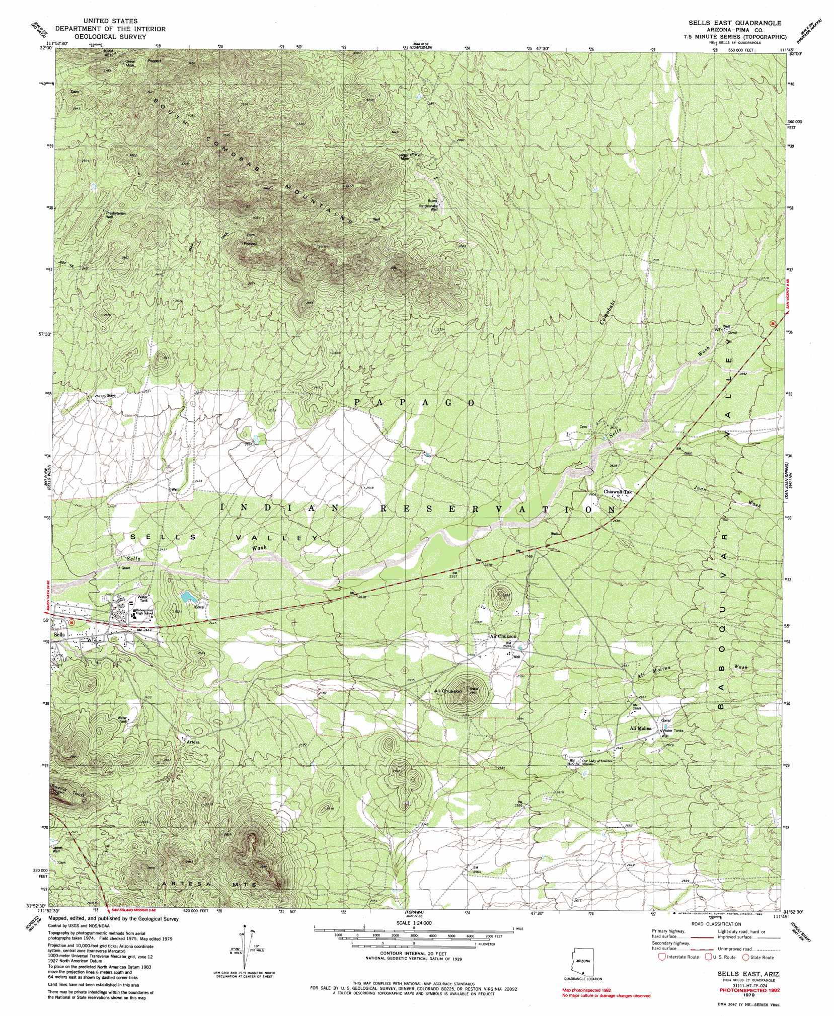
Sells East Topo Map Arizona
To zoom in, hover over the map of Sells East
USGS Topo Quad 31111h7 - 1:24,000 scale
| Topo Map Name: | Sells East |
| USGS Topo Quad ID: | 31111h7 |
| Print Size: | ca. 21 1/4" wide x 27" high |
| Southeast Coordinates: | 31.875° N latitude / 111.75° W longitude |
| Map Center Coordinates: | 31.9375° N latitude / 111.8125° W longitude |
| U.S. State: | AZ |
| Filename: | o31111h7.jpg |
| Download Map JPG Image: | Sells East topo map 1:24,000 scale |
| Map Type: | Topographic |
| Topo Series: | 7.5´ |
| Map Scale: | 1:24,000 |
| Source of Map Images: | United States Geological Survey (USGS) |
| Alternate Map Versions: |
Sells East AZ 1979, updated 1979 Download PDF Buy paper map Sells East AZ 1979, updated 1985 Download PDF Buy paper map Sells East AZ 1996, updated 2002 Download PDF Buy paper map Sells East AZ 2011 Download PDF Buy paper map Sells East AZ 2014 Download PDF Buy paper map |
1:24,000 Topo Quads surrounding Sells East
Gurli Put Vo |
Sand Wells |
Sil Nakya |
Black Hills |
San Ignacio Ranch |
Vainom Kug |
Ko Vaya |
Comobabi |
Haivana Nakya |
Pan Tak |
Gu Oidak |
Sells West |
Sells East |
San Juan Spring |
Kitt Peak |
Chukut Kuk |
Cowlic |
Topawa |
Chiuli Shaik |
Baboquivari Peak |
Tecolote Ranch |
Vamori |
South Komelik |
Aguirre Peak |
Mildred Peak |
> Back to 31111e1 at 1:100,000 scale
> Back to 31110a1 at 1:250,000 scale
> Back to U.S. Topo Maps home
Sells East topo map: Gazetteer
Sells East: Mines
Cababi Mine elevation 920m 3018′Green Mine elevation 939m 3080′
Jaeger Mine elevation 884m 2900′
Midnite Mine elevation 851m 2791′
Sells East: Populated Places
Ali Chukson elevation 787m 2582′Ali Molina elevation 812m 2664′
Artesa elevation 755m 2477′
Chiawuli Tak elevation 797m 2614′
Chukson elevation 791m 2595′
Sells East: Streams
Ali Molina Wash elevation 744m 2440′Comobabi Wash elevation 783m 2568′
San Juan Wash elevation 0m 0′
Sells East: Summits
Ali Chukson elevation 879m 2883′Suwuk Tontk elevation 877m 2877′
Sells East: Wells
James Well elevation 747m 2450′Presbyterian Well elevation 830m 2723′
Rattlesnake Well elevation 858m 2814′
Sells East digital topo map on disk
Buy this Sells East topo map showing relief, roads, GPS coordinates and other geographical features, as a high-resolution digital map file on DVD: