Charleston Topo Map South Carolina
To zoom in, hover over the map of Charleston
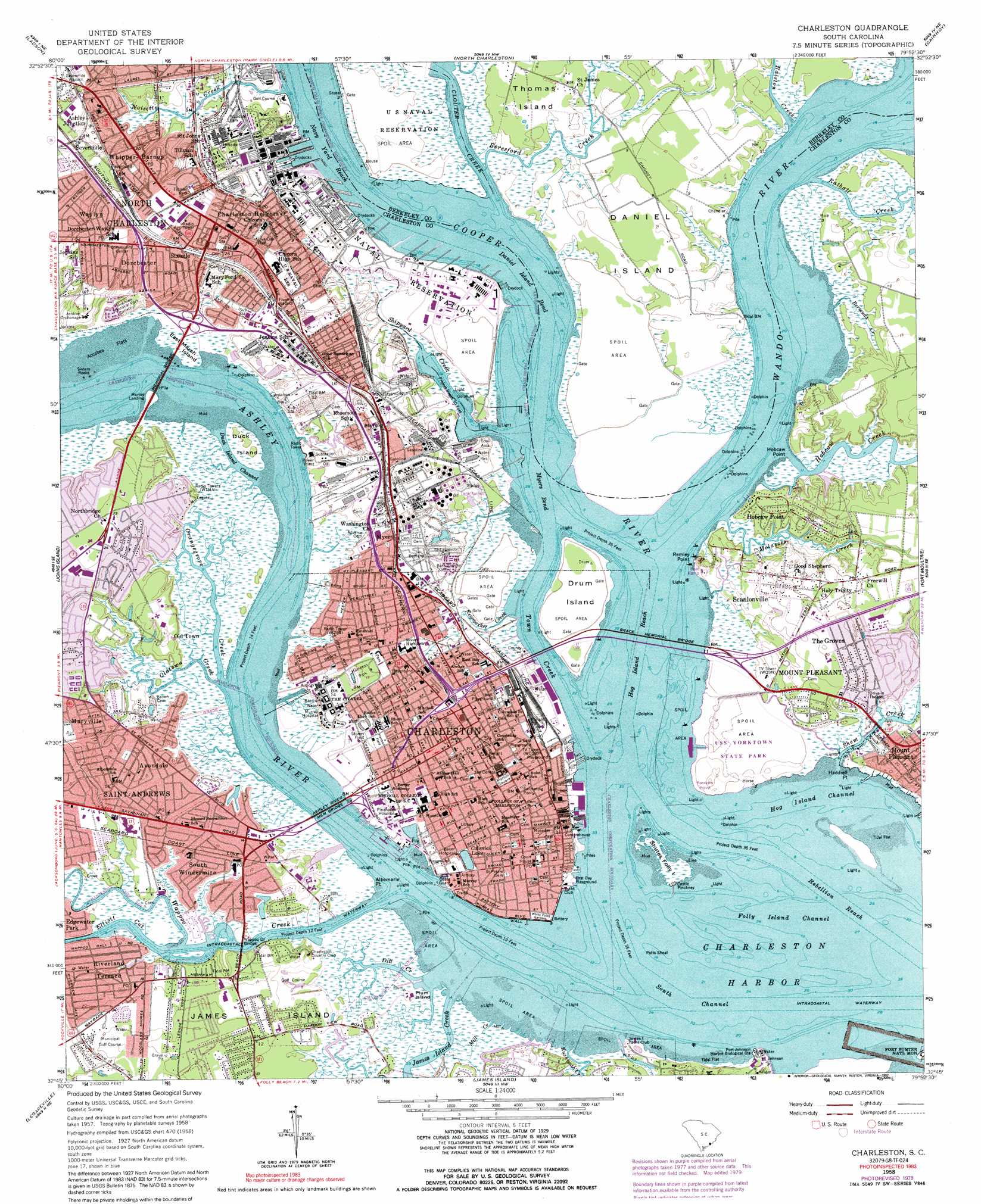
USGS Topo Quad 32079g8 - 1:24,000 scale
| Topo Map Name: | Charleston |
| USGS Topo Quad ID: | 32079g8 |
| Print Size: | ca. 21 1/4" wide x 27" high |
| Southeast Coordinates: | 32.75° N latitude / 79.875° W longitude |
| Map Center Coordinates: | 32.8125° N latitude / 79.9375° W longitude |
| U.S. State: | SC |
| Filename: | o32079g8.jpg |
| Download Map JPG Image: | Charleston topo map 1:24,000 scale |
| Map Type: | Topographic |
| Topo Series: | 7.5´ |
| Map Scale: | 1:24,000 |
| Source of Map Images: | United States Geological Survey (USGS) |
| Alternate Map Versions: |
Charleston SC 1948 Download PDF Buy paper map Charleston SC 1948 Download PDF Buy paper map Charleston SC 1958, updated 1959 Download PDF Buy paper map Charleston SC 1958, updated 1968 Download PDF Buy paper map Charleston SC 1958, updated 1973 Download PDF Buy paper map Charleston SC 1958, updated 1979 Download PDF Buy paper map Charleston SC 1958, updated 1992 Download PDF Buy paper map Charleston SC 1994, updated 2000 Download PDF Buy paper map Charleston SC 2011 Download PDF Buy paper map Charleston SC 2014 Download PDF Buy paper map |
1:24,000 Topo Quads surrounding Charleston
Summerville |
Mount Holly |
Kittredge |
Huger |
Ocean Bay |
Stallsville |
Ladson |
North Charleston |
Cainhoy |
Sewee Bay |
Ravenel |
Johns Island |
Charleston |
Fort Moultrie |
Capers Inlet |
Wadmalaw Island |
Legareville |
James Island |
||
Rockville |
Kiawah Island |
> Back to 32079e1 at 1:100,000 scale
> Back to 32078a1 at 1:250,000 scale
> Back to U.S. Topo Maps home
Charleston topo map: Gazetteer
Charleston: Airports
Medical University of South Carolina Heliport elevation 3m 9′Charleston: Areas
Charleston Neck elevation 7m 22′Charleston: Bars
Middle Ground elevation 0m 0′Charleston: Bays
Charleston Harbor elevation 0m 0′Charleston: Bends
Daniel Island Bend elevation 0m 0′Myers Bend elevation 0m 0′
Charleston: Bridges
Arthur J. Ravenel Bridge elevation 0m 0′Arthur Ravenel Junior Bridge elevation 5m 16′
Arthur Ravenel Junior Bridge elevation 5m 16′
Ashley River Memorial Bridge elevation 0m 0′
John P Grace Memorial Bridge elevation 0m 0′
John P. Grace Memorial Bridge (historical) elevation 0m 0′
Memorial Bridge elevation 0m 0′
Silas N Pearman Bridge elevation 0m 0′
Wappoo Creek Bridge elevation 0m 0′
Charleston: Canals
Fivemile Viaduct elevation 5m 16′Sevenmile Viaduct elevation 6m 19′
Charleston: Capes
Albemarle Point elevation 1m 3′Haddrell Point elevation 0m 0′
Hobcaw Point elevation 0m 0′
Oyster Point elevation 8m 26′
Patriots Point elevation 0m 0′
Remley Point elevation 0m 0′
Charleston: Channels
Bennis Reach elevation 0m 0′Custom House Reach elevation 4m 13′
Daniel Island Reach elevation 0m 0′
Drum Island Reach elevation 3m 9′
Duck Island Channel elevation 0m 0′
Elliott Cut elevation 0m 0′
Folly Island Channel elevation 0m 0′
Hog Island Channel elevation 0m 0′
Hog Island Reach elevation 0m 0′
Horse Reach elevation 0m 0′
Navy Yard Reach elevation 0m 0′
Rebellion Reach elevation 0m 0′
South Channel elevation 0m 0′
Town Creek elevation 0m 0′
Town Creek Lower Reach elevation 0m 0′
Town Creek Upper Reach elevation 0m 0′
Charleston: Crossings
Hibbens Ferry (historical) elevation 2m 6′Interchange 215 elevation 8m 26′
Interchange 216 elevation 3m 9′
Interchange 217 elevation 6m 19′
Interchange 218 elevation 3m 9′
Interchange 219 elevation 7m 22′
Interchange 220 elevation 5m 16′
Interchange 221 elevation 3m 9′
Miltons Ferry (historical) elevation 0m 0′
Charleston: Flats
Accabee Flats elevation 0m 0′Charleston: Islands
Daniel Island elevation 2m 6′Drum Island elevation 7m 22′
Duck Island elevation 2m 6′
East Marsh Island elevation 3m 9′
Hog Island elevation 3m 9′
Plum Island elevation 4m 13′
Shutes Folly Island elevation 3m 9′
Thomas Island elevation 4m 13′
Charleston: Lakes
Colonial Lake elevation 3m 9′Charleston: Parks
Cannon Park elevation 4m 13′Charles Pinckney National Historic Site elevation 3m 9′
Charles Towne Landing elevation 2m 6′
Charles Towne Landing State Historic Site elevation 16m 52′
Charleston Historic District elevation 7m 22′
East Bay Playground elevation 2m 6′
Hampton Park elevation 3m 9′
Harmon Field elevation 2m 6′
Johnson Hagood Memorial Stadium elevation 2m 6′
Mall Playground elevation 5m 16′
Marion Square elevation 6m 19′
Martins Park elevation 5m 16′
Stoney Field elevation 2m 6′
Summerall Field elevation 3m 9′
Tillman Park elevation 6m 19′
USS Yorktown State Park elevation 6m 19′
Washington Park elevation 6m 19′
White Point Gardens elevation 5m 16′
Woodahl Park elevation 3m 9′
Wragg Square elevation 4m 13′
Wraggs Mall elevation 6m 19′
Charleston: Pillars
Sisters Rocks elevation 0m 0′Charleston: Populated Places
Anson Borough Homes elevation 3m 9′Ashley Forest elevation 4m 13′
Ashley Junction elevation 3m 9′
Ashley Shores elevation 6m 19′
Ashleyville elevation 5m 16′
Avondale elevation 4m 13′
Bayview Acres elevation 3m 9′
Byrnes Downs elevation 5m 16′
Charles Towne Village elevation 4m 13′
Charleston elevation 6m 19′
Charleston Heights elevation 6m 19′
Charlestowne Estates elevation 5m 16′
Cherokee Place elevation 9m 29′
Chesterfield elevation 5m 16′
Chicora Place elevation 4m 13′
Cooper Estates elevation 4m 13′
Country Club Estates elevation 3m 9′
Daniel Jenkins Homes elevation 5m 16′
Dogwood Park elevation 6m 19′
Dorchester elevation 4m 13′
Gadsden Green Homes elevation 3m 9′
Garden Hill elevation 6m 19′
George S Legare Homes elevation 0m 0′
Green Acres elevation 3m 9′
Grove Creek Village elevation 4m 13′
Harbor View elevation 4m 13′
Hibernian Heights elevation 9m 29′
Hillside elevation 2m 6′
Hobcaw Point elevation 3m 9′
I'On elevation 1m 3′
Laurel Park elevation 4m 13′
Marlborough elevation 2m 6′
Maryville elevation 1m 3′
Millwood elevation 2m 6′
Moreland elevation 3m 9′
Murray Landing elevation 0m 0′
Myers elevation 7m 22′
North Charleston elevation 6m 19′
Northbridge elevation 4m 13′
Oak Forest elevation 2m 6′
Old Town elevation 3m 9′
Parkshire elevation 5m 16′
Parkwood Estates elevation 2m 6′
Remleys (historical) elevation 0m 0′
Remleys Point elevation 5m 16′
Riverland Terrace elevation 5m 16′
Rosemont elevation 7m 22′
Saint Andrews elevation 1m 3′
Sandhurst elevation 6m 19′
Scanlonville elevation 1m 3′
South Windermire elevation 6m 19′
The Crescent elevation 7m 22′
The Groves elevation 6m 19′
Tillman Homes elevation 8m 26′
Union Heights elevation 5m 16′
Wappo Heights elevation 5m 16′
Waylyn elevation 7m 22′
Wespanee elevation 1m 3′
Whipper-Barnoy elevation 8m 26′
Windsor Place elevation 8m 26′
Woodlawn elevation 3m 9′
Wragg Borough Homes elevation 3m 9′
Charleston: Post Offices
Charleston Post Office elevation 9m 29′East Bay Post Office elevation 4m 13′
Mount Pleasant Post Office elevation 4m 13′
Pinehaven Post Office elevation 9m 29′
Saint Andrews Post Office elevation 4m 13′
Charleston: Streams
Ashley River elevation 0m 0′Beresford Creek elevation 0m 0′
Beresford Creek elevation 0m 0′
Bermuda Creek elevation 1m 3′
Clouter Creek elevation 0m 0′
Cooper River elevation 0m 0′
Dill Creek elevation 0m 0′
Hobcaw Creek elevation 0m 0′
James Island Creek elevation 0m 0′
Kushiwah Creek elevation 1m 3′
Mill Creek elevation 0m 0′
Molasses Creek elevation 0m 0′
Newmarket Creek elevation 0m 0′
Noisette Creek elevation 0m 0′
Oldtown Creek elevation 0m 0′
Orangegrove Creek elevation 0m 0′
Ralston Creek elevation -1m -4′
Rathall Creek elevation 0m 0′
Shem Creek elevation 0m 0′
Shipyard Creek elevation 0m 0′
Wando River elevation 0m 0′
Wappoo Creek elevation 0m 0′
Charleston digital topo map on disk
Buy this Charleston topo map showing relief, roads, GPS coordinates and other geographical features, as a high-resolution digital map file on DVD:
South Carolina, Western North Carolina & Northeastern Georgia
Buy digital topo maps: South Carolina, Western North Carolina & Northeastern Georgia