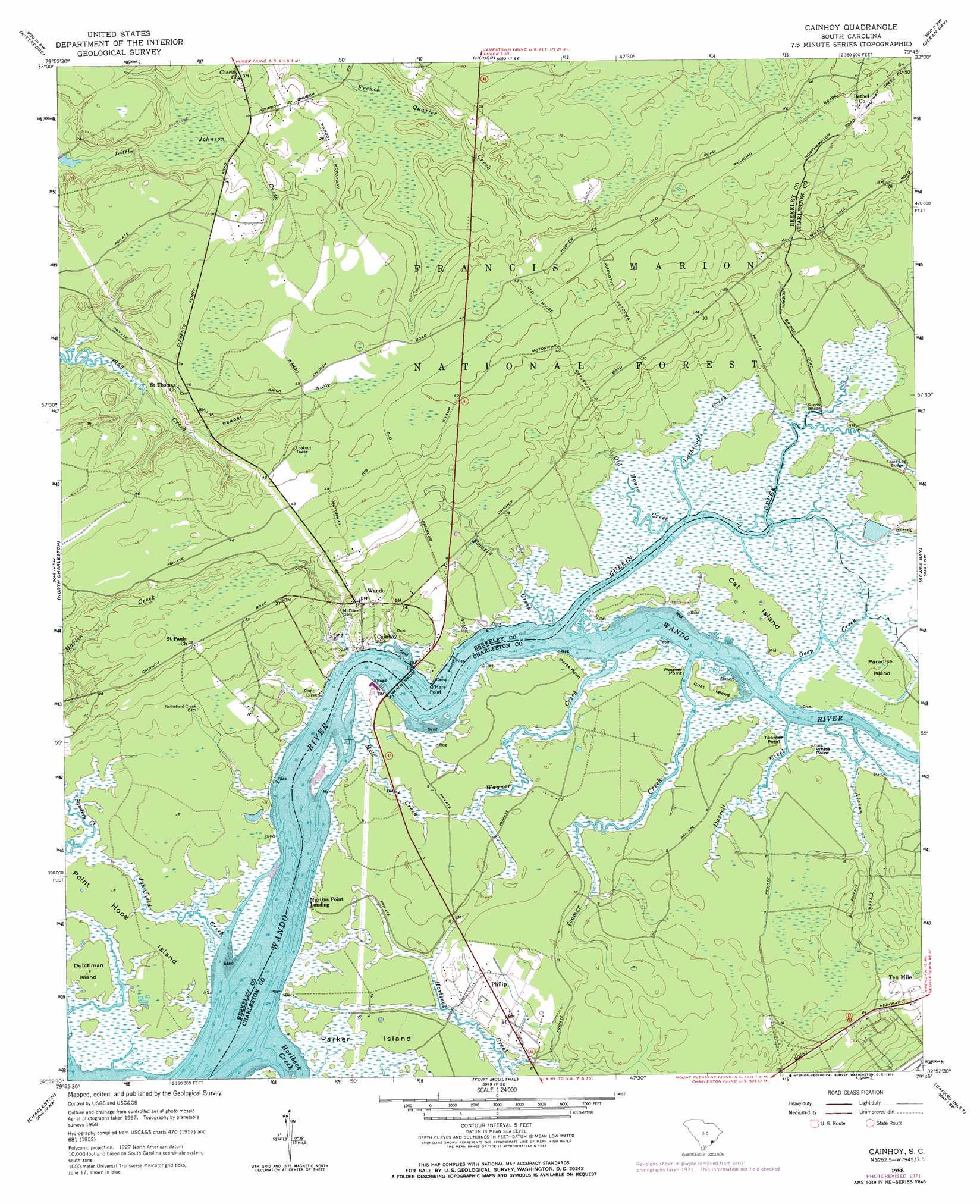
Cainhoy Topo Map South Carolina
To zoom in, hover over the map of Cainhoy
USGS Topo Quad 32079h7 - 1:24,000 scale
| Topo Map Name: | Cainhoy |
| USGS Topo Quad ID: | 32079h7 |
| Print Size: | ca. 21 1/4" wide x 27" high |
| Southeast Coordinates: | 32.875° N latitude / 79.75° W longitude |
| Map Center Coordinates: | 32.9375° N latitude / 79.8125° W longitude |
| U.S. State: | SC |
| Filename: | o32079h7.jpg |
| Download Map JPG Image: | Cainhoy topo map 1:24,000 scale |
| Map Type: | Topographic |
| Topo Series: | 7.5´ |
| Map Scale: | 1:24,000 |
| Source of Map Images: | United States Geological Survey (USGS) |
| Alternate Map Versions: |
Wando SC 1943 Download PDF Buy paper map Cainhoy SC 1958, updated 1960 Download PDF Buy paper map Cainhoy SC 1958, updated 1964 Download PDF Buy paper map Cainhoy SC 1958, updated 1973 Download PDF Buy paper map Cainhoy SC 2011 Download PDF Buy paper map Cainhoy SC 2014 Download PDF Buy paper map |
| FStopo: | US Forest Service topo Cainhoy is available: Download FStopo PDF Download FStopo TIF |
1:24,000 Topo Quads surrounding Cainhoy
Moncks Corner |
Cordesville |
Bethera |
Shulerville |
Honey Hill |
Mount Holly |
Kittredge |
Huger |
Ocean Bay |
Awendaw |
Ladson |
North Charleston |
Cainhoy |
Sewee Bay |
Bull Island |
Johns Island |
Charleston |
Fort Moultrie |
Capers Inlet |
|
Legareville |
James Island |
> Back to 32079e1 at 1:100,000 scale
> Back to 32078a1 at 1:250,000 scale
> Back to U.S. Topo Maps home
Cainhoy topo map: Gazetteer
Cainhoy: Airports
East Cooper Airport elevation 3m 9′Cainhoy: Bridges
Guerin Bridge elevation 0m 0′Three Log Bridge elevation 1m 3′
Wando Bridge elevation 0m 0′
Cainhoy: Capes
Darts Point elevation 1m 3′O'Hare Point elevation 1m 3′
Toomer Point elevation 1m 3′
Wagner Point elevation 1m 3′
White Point elevation 1m 3′
Cainhoy: Islands
Cat Island elevation 2m 6′Dutchman Island elevation 2m 6′
Goat Island elevation 1m 3′
Juba Island elevation 1m 3′
Murphy Island elevation 1m 3′
Paradise Island elevation 1m 3′
Parker Island elevation 1m 3′
Point Hope Island elevation 1m 3′
Cainhoy: Populated Places
Cainhoy elevation 5m 16′Martins Point Landing elevation 3m 9′
Old Vat (historical) elevation 9m 29′
Philip elevation 3m 9′
Wando elevation 4m 13′
Cainhoy: Post Offices
Huger Post Office elevation 10m 32′Cainhoy: Streams
Alston Creek elevation 0m 0′Darrell Creek elevation 1m 3′
Deep Creek elevation 0m 0′
Fogarty Creek elevation 1m 3′
Guerin Creek elevation 0m 0′
Horlbeck Creek elevation 0m 0′
Johnfield Creek elevation 0m 0′
Lachicotte Creek elevation 0m 0′
Little Johnson Creek elevation 1m 3′
Mill Creek elevation 1m 3′
Old House Creek elevation 0m 0′
Pepper Gully elevation 3m 9′
Toomer Creek elevation 0m 0′
Wagner Creek elevation 0m 0′
Cainhoy digital topo map on disk
Buy this Cainhoy topo map showing relief, roads, GPS coordinates and other geographical features, as a high-resolution digital map file on DVD:
South Carolina, Western North Carolina & Northeastern Georgia
Buy digital topo maps: South Carolina, Western North Carolina & Northeastern Georgia