Pritchardville Topo Map South Carolina
To zoom in, hover over the map of Pritchardville
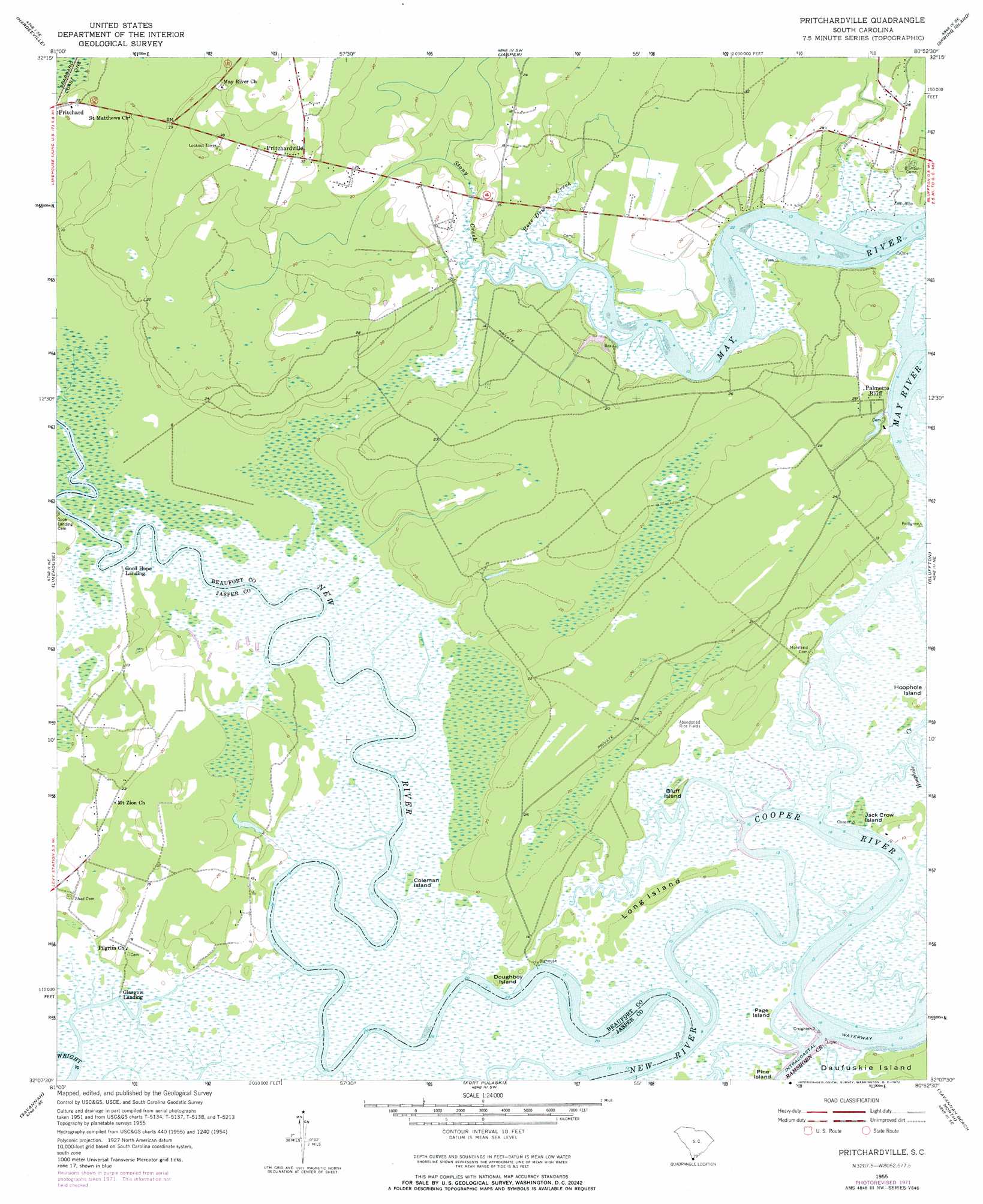
USGS Topo Quad 32080b8 - 1:24,000 scale
| Topo Map Name: | Pritchardville |
| USGS Topo Quad ID: | 32080b8 |
| Print Size: | ca. 21 1/4" wide x 27" high |
| Southeast Coordinates: | 32.125° N latitude / 80.875° W longitude |
| Map Center Coordinates: | 32.1875° N latitude / 80.9375° W longitude |
| U.S. State: | SC |
| Filename: | o32080b8.jpg |
| Download Map JPG Image: | Pritchardville topo map 1:24,000 scale |
| Map Type: | Topographic |
| Topo Series: | 7.5´ |
| Map Scale: | 1:24,000 |
| Source of Map Images: | United States Geological Survey (USGS) |
| Alternate Map Versions: |
Pritchardville SC 1955, updated 1956 Download PDF Buy paper map Pritchardville SC 1955, updated 1972 Download PDF Buy paper map Pritchardville SC 1955, updated 1973 Download PDF Buy paper map Pritchardville SC 2011 Download PDF Buy paper map Pritchardville SC 2014 Download PDF Buy paper map |
1:24,000 Topo Quads surrounding Pritchardville
Hardeeville Nw |
Tillman |
Ridgeland |
Laurel Bay |
Beaufort |
Rincon |
Hardeeville |
Jasper |
Spring Island |
Parris Island |
Port Wentworth |
Limehouse |
Pritchardville |
Bluffton |
Hilton Head |
Garden City |
Savannah |
Fort Pulaski |
Tybee Island North |
|
Burroughs |
Isle Of Hope |
Wassaw Sound |
Tybee Island South |
> Back to 32080a1 at 1:100,000 scale
> Back to 32080a1 at 1:250,000 scale
> Back to U.S. Topo Maps home
Pritchardville topo map: Gazetteer
Pritchardville: Capes
May River Neck elevation 6m 19′Pritchardville: Channels
Cooper River elevation 2m 6′Pritchardville: Dams
Union Camp Pond Dam D-2939 elevation 3m 9′Pritchardville: Islands
Bluff Island elevation 3m 9′Coleman Island elevation 1m 3′
Crane Island elevation 2m 6′
Doughboy Island elevation 3m 9′
Jack Crow Island elevation 3m 9′
Long Island elevation 3m 9′
Page Island elevation 3m 9′
Pritchardville: Populated Places
Glasgow Landing elevation 3m 9′Good Hope Landing elevation 2m 6′
Palmetto Bluff elevation 6m 19′
Pritchardville elevation 10m 32′
Pritchardville: Streams
Rose Dew Creek elevation 3m 9′Stony Creek elevation 3m 9′
Pritchardville: Swamps
Mile Swamp elevation 0m 0′Shoe Quarter Swamp elevation 1m 3′
Pritchardville digital topo map on disk
Buy this Pritchardville topo map showing relief, roads, GPS coordinates and other geographical features, as a high-resolution digital map file on DVD:
South Carolina, Western North Carolina & Northeastern Georgia
Buy digital topo maps: South Carolina, Western North Carolina & Northeastern Georgia