Saint Helena Sound Topo Map South Carolina
To zoom in, hover over the map of Saint Helena Sound
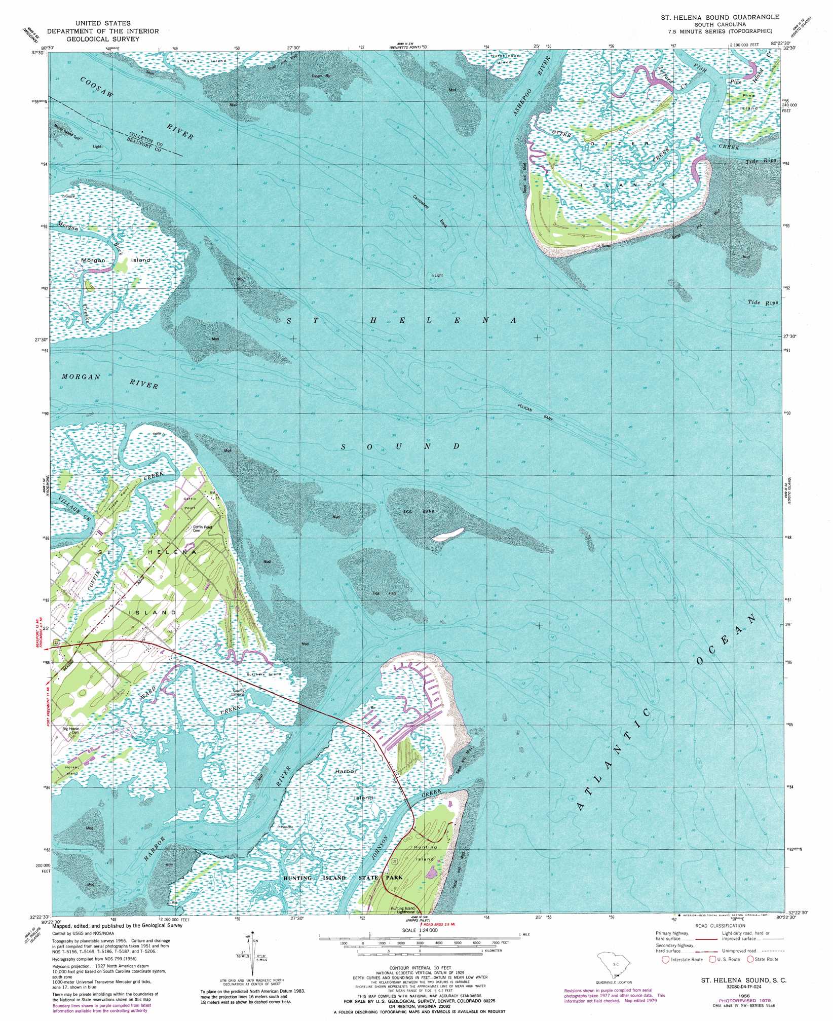
USGS Topo Quad 32080d4 - 1:24,000 scale
| Topo Map Name: | Saint Helena Sound |
| USGS Topo Quad ID: | 32080d4 |
| Print Size: | ca. 21 1/4" wide x 27" high |
| Southeast Coordinates: | 32.375° N latitude / 80.375° W longitude |
| Map Center Coordinates: | 32.4375° N latitude / 80.4375° W longitude |
| U.S. State: | SC |
| Filename: | o32080d4.jpg |
| Download Map JPG Image: | Saint Helena Sound topo map 1:24,000 scale |
| Map Type: | Topographic |
| Topo Series: | 7.5´ |
| Map Scale: | 1:24,000 |
| Source of Map Images: | United States Geological Survey (USGS) |
| Alternate Map Versions: |
St. Helena Sound SC 1956, updated 1957 Download PDF Buy paper map St. Helena Sound SC 1956, updated 1957 Download PDF Buy paper map St. Helena Sound SC 1956, updated 1979 Download PDF Buy paper map St. Helena Sound SC 1956, updated 1987 Download PDF Buy paper map Saint Helena Sound SC 2011 Download PDF Buy paper map Saint Helena Sound SC 2014 Download PDF Buy paper map |
1:24,000 Topo Quads surrounding Saint Helena Sound
Whitehall |
Green Pond |
Fenwick |
Adams Run |
Wadmalaw Island |
Dale |
Wiggins |
Bennetts Point |
Edisto Island |
Rockville |
Beaufort |
Frogmore |
Saint Helena Sound |
Edisto Beach |
|
Parris Island |
Saint Phillips Island |
Fripps Inlet |
||
Hilton Head |
> Back to 32080a1 at 1:100,000 scale
> Back to 32080a1 at 1:250,000 scale
> Back to U.S. Topo Maps home
Saint Helena Sound topo map: Gazetteer
Saint Helena Sound: Bars
Combahee Bank elevation 0m 0′Egg Bank elevation 0m 0′
Marsh Island Spit elevation 0m 0′
Oyster Bank elevation 0m 0′
Pelican Bank elevation 0m 0′
Saint Helena Sound: Bays
Saint Helena Sound elevation 0m 0′Saint Helena Sound: Capes
Coffin Point elevation 3m 9′Fripps Point elevation 3m 9′
Pelican Point elevation 4m 13′
Saint Helena Sound: Channels
Otter Creek elevation 2m 6′Saint Helena Sound: Guts
Johnson Creek elevation 0m 0′Saint Helena Sound: Islands
Butchers Island elevation 2m 6′Harbor Island elevation 2m 6′
Horse Island elevation 1m 3′
Otter Islands elevation 2m 6′
Pine Island elevation 2m 6′
Saint Helena Sound: Populated Places
Cedar Reef Villas elevation 2m 6′Nautical Watch Villas elevation 2m 6′
Oceanmarsh Subdivision elevation 3m 9′
Saint Helena Sound: Streams
Ashepoo River elevation 0m 0′Coffin Creek elevation 0m 0′
Coosaw River elevation 0m 0′
Fish Creek elevation 0m 0′
Jefford Creek elevation 0m 0′
Morgan River elevation 0m 0′
Pine Island Creek elevation 0m 0′
Ward Creek elevation 0m 0′
Saint Helena Sound digital topo map on disk
Buy this Saint Helena Sound topo map showing relief, roads, GPS coordinates and other geographical features, as a high-resolution digital map file on DVD:
South Carolina, Western North Carolina & Northeastern Georgia
Buy digital topo maps: South Carolina, Western North Carolina & Northeastern Georgia