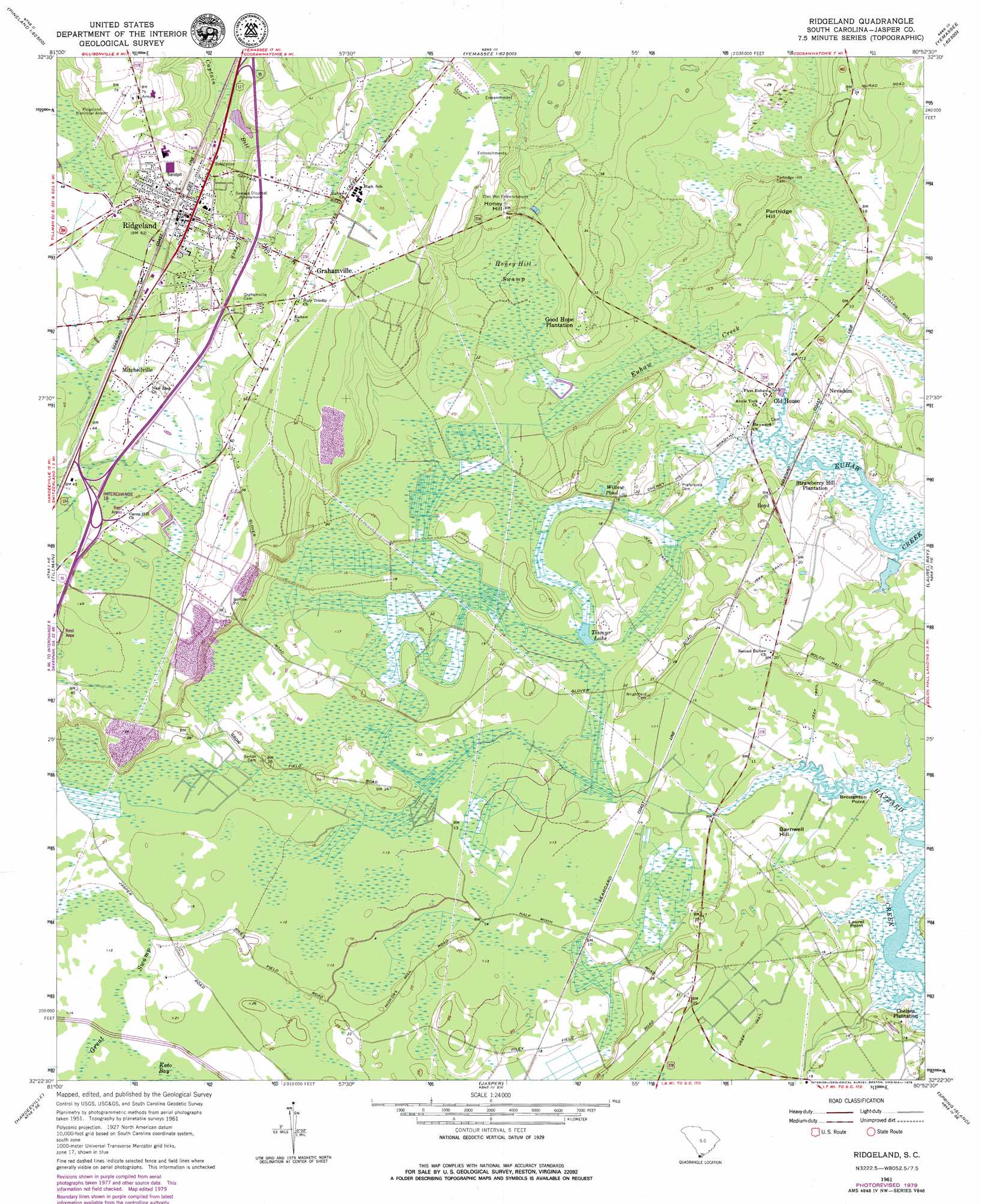
Ridgeland Topo Map South Carolina
To zoom in, hover over the map of Ridgeland
USGS Topo Quad 32080d8 - 1:24,000 scale
| Topo Map Name: | Ridgeland |
| USGS Topo Quad ID: | 32080d8 |
| Print Size: | ca. 21 1/4" wide x 27" high |
| Southeast Coordinates: | 32.375° N latitude / 80.875° W longitude |
| Map Center Coordinates: | 32.4375° N latitude / 80.9375° W longitude |
| U.S. State: | SC |
| Filename: | o32080d8.jpg |
| Download Map JPG Image: | Ridgeland topo map 1:24,000 scale |
| Map Type: | Topographic |
| Topo Series: | 7.5´ |
| Map Scale: | 1:24,000 |
| Source of Map Images: | United States Geological Survey (USGS) |
| Alternate Map Versions: |
Ridgeland SC 1961, updated 1964 Download PDF Buy paper map Ridgeland SC 1961, updated 1979 Download PDF Buy paper map Ridgeland SC 2011 Download PDF Buy paper map Ridgeland SC 2014 Download PDF Buy paper map |
1:24,000 Topo Quads surrounding Ridgeland
Furman |
Grays |
Mcphersonville |
Yemassee |
Whitehall |
Pineland |
Calfpen Bay |
Coosawhatchie |
Sheldon |
Dale |
Hardeeville Nw |
Tillman |
Ridgeland |
Laurel Bay |
Beaufort |
Rincon |
Hardeeville |
Jasper |
Spring Island |
Parris Island |
Port Wentworth |
Limehouse |
Pritchardville |
Bluffton |
Hilton Head |
> Back to 32080a1 at 1:100,000 scale
> Back to 32080a1 at 1:250,000 scale
> Back to U.S. Topo Maps home
Ridgeland topo map: Gazetteer
Ridgeland: Airports
Ridgeland Municipal Airport elevation 22m 72′Ridgeland: Capes
Broughton Point elevation 1m 3′Laurel Point elevation 1m 3′
Ridgeland: Crossings
Interchange 18 elevation 13m 42′Interchange 21 elevation 12m 39′
Ridgeland: Dams
South Carolina Noname 27012 D-2591 Dam elevation 1m 3′Ridgeland: Lakes
Tismyr Lake elevation 4m 13′Willow Pond elevation 4m 13′
Ridgeland: Parks
Harold Turpin Park elevation 16m 52′Ridge Pointe Square elevation 18m 59′
Ridgeland: Populated Places
Boyd elevation 8m 26′Grahamville elevation 17m 55′
Mitchellville elevation 13m 42′
Nevadum elevation 5m 16′
Old House elevation 5m 16′
Ridgeland elevation 18m 59′
Ridgeland: Post Offices
Ridgeland Post Office elevation 20m 65′Ridgeland: Summits
Barnwell Hill elevation 5m 16′Honey Hill elevation 12m 39′
Partridge Hill elevation 11m 36′
Ridgeland: Swamps
Great Swamp elevation 4m 13′Honey Hill Swamp elevation 4m 13′
Mount Pleasant Back Water elevation 4m 13′
Richfield Lake elevation 4m 13′
Wellington Back Water elevation 4m 13′
Ridgeland digital topo map on disk
Buy this Ridgeland topo map showing relief, roads, GPS coordinates and other geographical features, as a high-resolution digital map file on DVD:
South Carolina, Western North Carolina & Northeastern Georgia
Buy digital topo maps: South Carolina, Western North Carolina & Northeastern Georgia