Bennetts Point Topo Map South Carolina
To zoom in, hover over the map of Bennetts Point
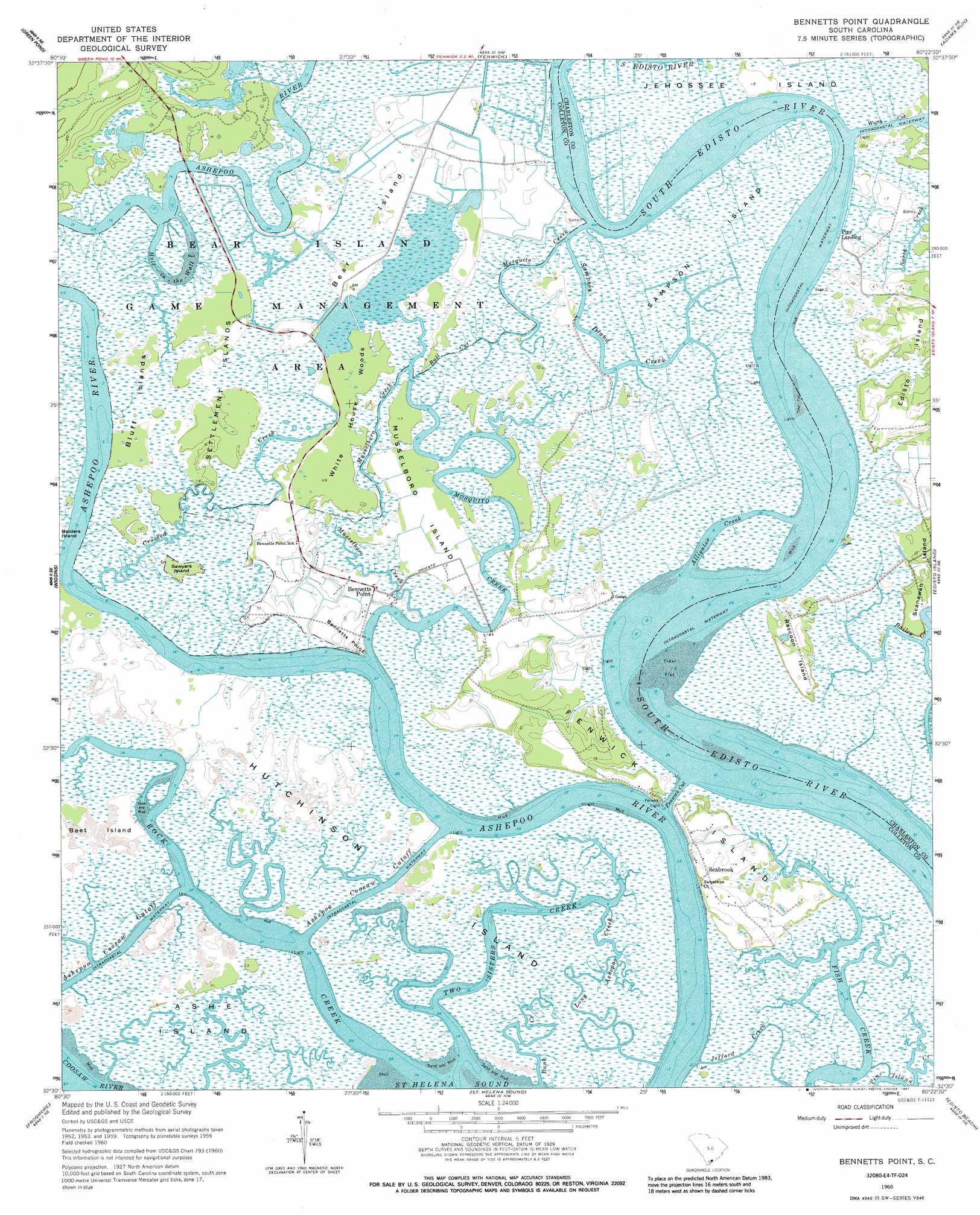
USGS Topo Quad 32080e4 - 1:24,000 scale
| Topo Map Name: | Bennetts Point |
| USGS Topo Quad ID: | 32080e4 |
| Print Size: | ca. 21 1/4" wide x 27" high |
| Southeast Coordinates: | 32.5° N latitude / 80.375° W longitude |
| Map Center Coordinates: | 32.5625° N latitude / 80.4375° W longitude |
| U.S. State: | SC |
| Filename: | o32080e4.jpg |
| Download Map JPG Image: | Bennetts Point topo map 1:24,000 scale |
| Map Type: | Topographic |
| Topo Series: | 7.5´ |
| Map Scale: | 1:24,000 |
| Source of Map Images: | United States Geological Survey (USGS) |
| Alternate Map Versions: |
Bennetts Point SC 1960, updated 1964 Download PDF Buy paper map Bennetts Point SC 1960, updated 1976 Download PDF Buy paper map Bennetts Point SC 1960, updated 1987 Download PDF Buy paper map Bennetts Point SC 2011 Download PDF Buy paper map Bennetts Point SC 2014 Download PDF Buy paper map |
1:24,000 Topo Quads surrounding Bennetts Point
Hendersonville |
Neyles |
Jacksonboro |
Osborn |
Ravenel |
Whitehall |
Green Pond |
Fenwick |
Adams Run |
Wadmalaw Island |
Dale |
Wiggins |
Bennetts Point |
Edisto Island |
Rockville |
Beaufort |
Frogmore |
Saint Helena Sound |
Edisto Beach |
|
Parris Island |
Saint Phillips Island |
Fripps Inlet |
> Back to 32080e1 at 1:100,000 scale
> Back to 32080a1 at 1:250,000 scale
> Back to U.S. Topo Maps home
Bennetts Point topo map: Gazetteer
Bennetts Point: Bends
Hole-in-the-Wall elevation 0m 0′Bennetts Point: Capes
Bennetts Point elevation 3m 9′Bennetts Point: Channels
Ashepoo Coosaw Cutoff elevation 0m 0′Bull Cut elevation 2m 6′
Fenwick Cut elevation 0m 0′
Watts Cut elevation 0m 0′
Bennetts Point: Islands
Ashe Island elevation 2m 6′Bear Island elevation 1m 3′
Beet Island elevation 2m 6′
Bluff Islands elevation 2m 6′
Fenwick Island elevation 5m 16′
Hutchinson Island elevation 2m 6′
Musselboro Island elevation 2m 6′
Raccoon Island elevation 2m 6′
Sampson Island elevation 2m 6′
Sawyers Island elevation 2m 6′
Settlement Islands elevation 2m 6′
Bennetts Point: Parks
Bear Island Game Management Area elevation 2m 6′Bennetts Point: Populated Places
Bennetts Point elevation 2m 6′Pine Landing elevation 2m 6′
Seabrook elevation 6m 19′
Bennetts Point: Streams
Alligator Creek elevation 0m 0′Bank Creek elevation 11m 36′
Crooked Creek elevation 0m 0′
Long Ashepoo Creek elevation 0m 0′
Mosquito Creek elevation 0m 0′
Musselboro Creek elevation 0m 0′
Rock Creek elevation 0m 0′
Sampson Island Creek elevation 2m 6′
Two Sisters Creek elevation 0m 0′
Bennetts Point: Woods
White House Woods elevation 3m 9′Bennetts Point digital topo map on disk
Buy this Bennetts Point topo map showing relief, roads, GPS coordinates and other geographical features, as a high-resolution digital map file on DVD:
South Carolina, Western North Carolina & Northeastern Georgia
Buy digital topo maps: South Carolina, Western North Carolina & Northeastern Georgia