Adams Run Topo Map South Carolina
To zoom in, hover over the map of Adams Run
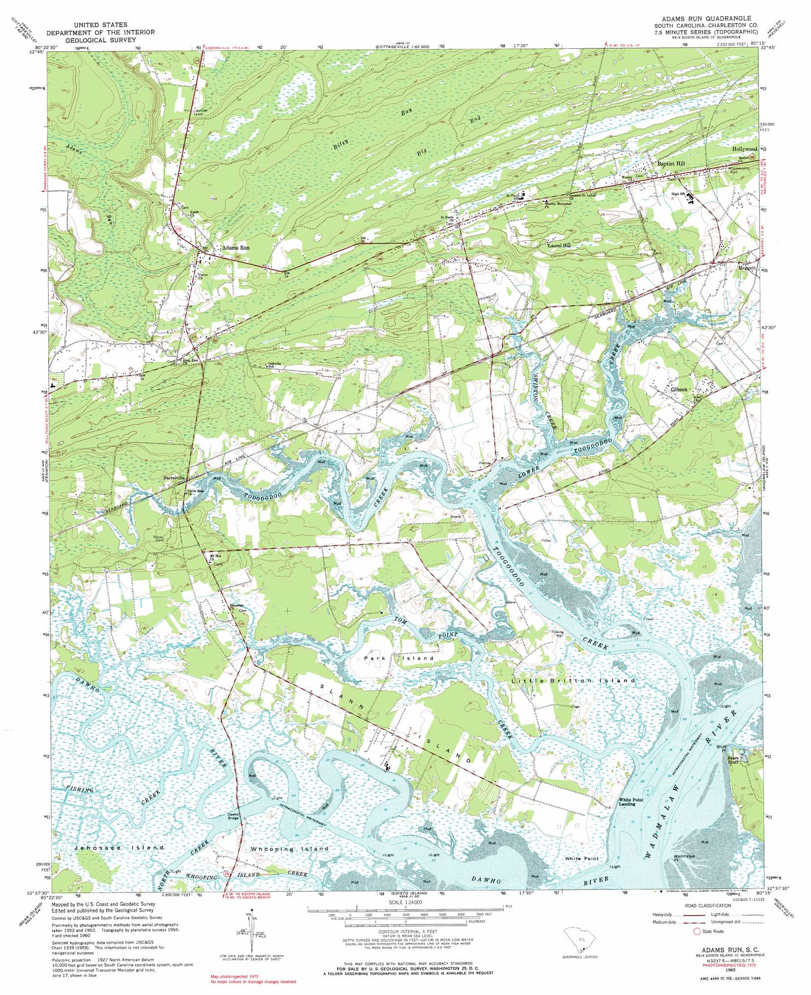
USGS Topo Quad 32080f3 - 1:24,000 scale
| Topo Map Name: | Adams Run |
| USGS Topo Quad ID: | 32080f3 |
| Print Size: | ca. 21 1/4" wide x 27" high |
| Southeast Coordinates: | 32.625° N latitude / 80.25° W longitude |
| Map Center Coordinates: | 32.6875° N latitude / 80.3125° W longitude |
| U.S. State: | SC |
| Filename: | o32080f3.jpg |
| Download Map JPG Image: | Adams Run topo map 1:24,000 scale |
| Map Type: | Topographic |
| Topo Series: | 7.5´ |
| Map Scale: | 1:24,000 |
| Source of Map Images: | United States Geological Survey (USGS) |
| Alternate Map Versions: |
Adams Run SC 1960, updated 1964 Download PDF Buy paper map Adams Run SC 1960, updated 1983 Download PDF Buy paper map Adams Run SC 1960, updated 1983 Download PDF Buy paper map Adams Run SC 2011 Download PDF Buy paper map Adams Run SC 2014 Download PDF Buy paper map |
1:24,000 Topo Quads surrounding Adams Run
Round O |
Cottageville |
Clubhouse Crossroads |
Stallsville |
Ladson |
Neyles |
Jacksonboro |
Osborn |
Ravenel |
Johns Island |
Green Pond |
Fenwick |
Adams Run |
Wadmalaw Island |
Legareville |
Wiggins |
Bennetts Point |
Edisto Island |
Rockville |
Kiawah Island |
Frogmore |
Saint Helena Sound |
Edisto Beach |
> Back to 32080e1 at 1:100,000 scale
> Back to 32080a1 at 1:250,000 scale
> Back to U.S. Topo Maps home
Adams Run topo map: Gazetteer
Adams Run: Airports
Too Goo Doo Farms Airport elevation 6m 19′Adams Run: Bridges
Dawho Bridge elevation 0m 0′Adams Run: Capes
Bluff Point elevation 1m 3′Wadmalaw Point elevation 2m 6′
White Point elevation 5m 16′
Adams Run: Dams
South Carolina Noname 10063 D-3044 Dam elevation 16m 52′Adams Run: Islands
Jehossee Island elevation 0m 0′Little Britton Island elevation 2m 6′
Park Island elevation 10m 32′
Slann Island elevation 9m 29′
Whooping Island elevation 2m 6′
Adams Run: Populated Places
Adams Run elevation 18m 59′Baptist Hill elevation 15m 49′
Barrelville elevation 7m 22′
Bears Bluff elevation 2m 6′
Gannon (historical) elevation 9m 29′
Gibson elevation 7m 22′
Laroche elevation 6m 19′
Laurel Hill elevation 12m 39′
White Point Landing elevation 4m 13′
Adams Run: Post Offices
Adams Run Post Office elevation 18m 59′Adams Run: Streams
Dawho River elevation 0m 0′Fishing Creek elevation 0m 0′
Lower Toogoodoo Creek elevation 0m 0′
North Creek elevation 0m 0′
Swinton Creek elevation 2m 6′
Tom Point Creek elevation 0m 0′
Toogoodoo Creek elevation 0m 0′
Wadmalaw River elevation 0m 0′
Adams Run: Swamps
Big Bay elevation 16m 52′Riley Bay elevation 16m 52′
Adams Run digital topo map on disk
Buy this Adams Run topo map showing relief, roads, GPS coordinates and other geographical features, as a high-resolution digital map file on DVD:
South Carolina, Western North Carolina & Northeastern Georgia
Buy digital topo maps: South Carolina, Western North Carolina & Northeastern Georgia