Johns Island Topo Map South Carolina
To zoom in, hover over the map of Johns Island
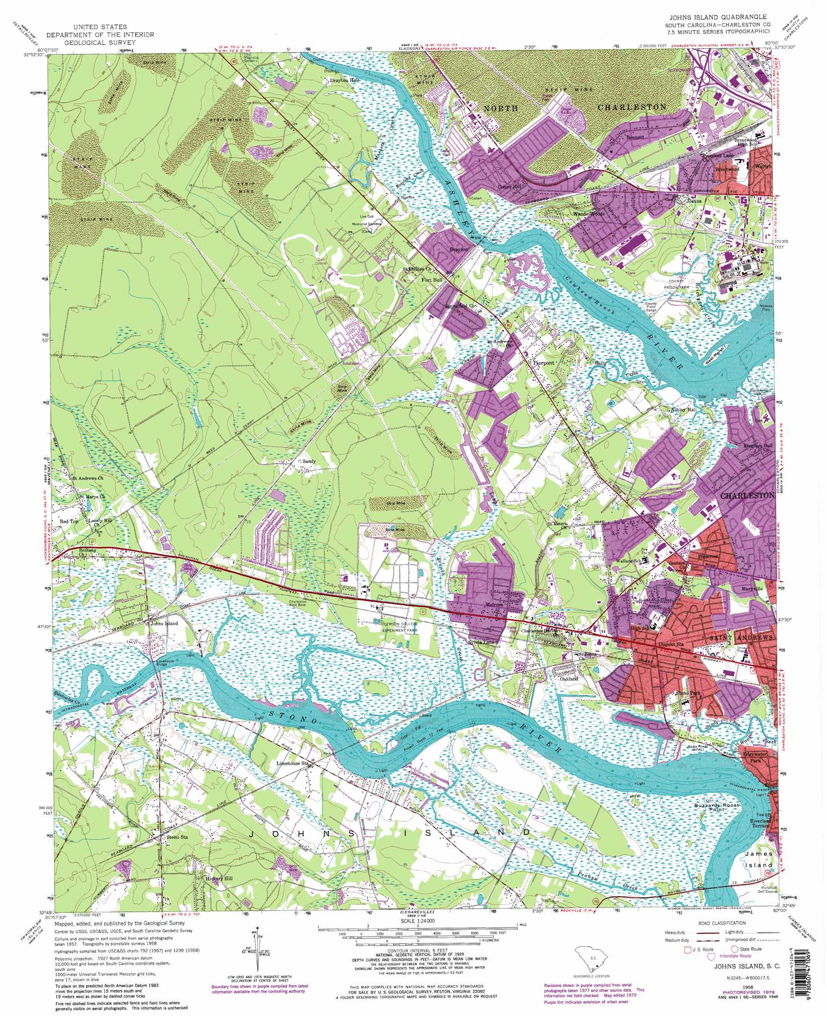
USGS Topo Quad 32080g1 - 1:24,000 scale
| Topo Map Name: | Johns Island |
| USGS Topo Quad ID: | 32080g1 |
| Print Size: | ca. 21 1/4" wide x 27" high |
| Southeast Coordinates: | 32.75° N latitude / 80° W longitude |
| Map Center Coordinates: | 32.8125° N latitude / 80.0625° W longitude |
| U.S. State: | SC |
| Filename: | o32080g1.jpg |
| Download Map JPG Image: | Johns Island topo map 1:24,000 scale |
| Map Type: | Topographic |
| Topo Series: | 7.5´ |
| Map Scale: | 1:24,000 |
| Source of Map Images: | United States Geological Survey (USGS) |
| Alternate Map Versions: |
Johns Island SC 1948 Download PDF Buy paper map Johns Island SC 1948 Download PDF Buy paper map Johns Island SC 1958, updated 1959 Download PDF Buy paper map Johns Island SC 1958, updated 1966 Download PDF Buy paper map Johns Island SC 1958, updated 1973 Download PDF Buy paper map Johns Island SC 1958, updated 1979 Download PDF Buy paper map Johns Island SC 1958, updated 1979 Download PDF Buy paper map Johns Island SC 2011 Download PDF Buy paper map Johns Island SC 2014 Download PDF Buy paper map |
1:24,000 Topo Quads surrounding Johns Island
Ridgeville |
Summerville |
Mount Holly |
Kittredge |
Huger |
Clubhouse Crossroads |
Stallsville |
Ladson |
North Charleston |
Cainhoy |
Osborn |
Ravenel |
Johns Island |
Charleston |
Fort Moultrie |
Adams Run |
Wadmalaw Island |
Legareville |
James Island |
|
Edisto Island |
Rockville |
Kiawah Island |
> Back to 32080e1 at 1:100,000 scale
> Back to 32080a1 at 1:250,000 scale
> Back to U.S. Topo Maps home
Johns Island topo map: Gazetteer
Johns Island: Bridges
Limehouse Bridge elevation 0m 0′Johns Island: Capes
Buzzards Roost Point elevation 3m 9′Johns Island: Channels
Cowhea Reach elevation 0m 0′Johns Island: Crossings
Bees Ferry (historical) elevation 0m 0′Interchange 213 elevation 8m 26′
Johns Island Ferry (historical) elevation 3m 9′
Johns Island: Islands
West Marsh Island elevation 1m 3′Johns Island: Parks
Fellowship Road Park elevation 8m 26′Magnolia Gardens elevation 5m 16′
Johns Island: Populated Places
Ashley Acres elevation 9m 29′Ashley Hall Manor elevation 6m 19′
Ashley Harbor elevation 6m 19′
Ashley Villas elevation 8m 26′
Bennett elevation 12m 39′
Bon Aire elevation 13m 42′
Brentwood elevation 7m 22′
Capri Isles elevation 1m 3′
Castlewood elevation 6m 19′
Church Creek elevation 7m 22′
Cohen Hill elevation 13m 42′
Covington Hills elevation 7m 22′
Dogwood Gardens elevation 7m 22′
Drayton elevation 11m 36′
Dupont Station elevation 7m 22′
Edgewater Park elevation 5m 16′
Essex Village elevation 7m 22′
Evanston Estates elevation 11m 36′
Faber Place elevation 11m 36′
Fetteressa elevation 11m 36′
Forest Acres West elevation 7m 22′
Forest Lakes elevation 6m 19′
Fort Bull elevation 11m 36′
Glyn Terrace elevation 9m 29′
Green Grove elevation 13m 42′
Greenwood Park elevation 9m 29′
Harrison Acres elevation 8m 26′
Heathwood elevation 6m 19′
Hickory Hall Plantation elevation 9m 29′
Hickory Hill elevation 9m 29′
Huntington Woods elevation 6m 19′
Indigo Point elevation 1m 3′
Johns Island elevation 6m 19′
Joshua elevation 9m 29′
Limehouse Station elevation 7m 22′
Long Branch Estates elevation 7m 22′
Magnolia Ranch elevation 9m 29′
Marsh Cove elevation 5m 16′
Melrose elevation 8m 26′
Murry Hill elevation 5m 16′
Myrtle Grove elevation 8m 26′
North Pine Point elevation 5m 16′
Oak Ridge elevation 13m 42′
Oakland elevation 7m 22′
Orange Grove Estates elevation 7m 22′
Orleans Estates elevation 5m 16′
Orleans Woods elevation 6m 19′
Parkdale elevation 1m 3′
Parsonage Point elevation 10m 32′
Pierpont elevation 10m 32′
Pinecrest elevation 7m 22′
Plantation Estates elevation 6m 19′
Ponderosa elevation 5m 16′
Red Top elevation 2m 6′
Saint Andrews Heights elevation 7m 22′
Sandy elevation 5m 16′
Shadowmoss elevation 11m 36′
Shell Point elevation 7m 22′
Sherwood Forest elevation 8m 26′
Springfield elevation 10m 32′
Stone Park elevation 9m 29′
Stono Station elevation 6m 19′
Sylecope elevation 6m 19′
Sylvia Lane elevation 9m 29′
Wando Gardens elevation 12m 39′
Wando Woods elevation 10m 32′
Wappoo Shores elevation 6m 19′
Johns Island: Post Offices
Ashley River Post Office elevation 6m 19′Johns Island: Streams
Brickyard Creek elevation 0m 0′Bulls Creek elevation 0m 0′
Church Creek elevation 0m 0′
Keivling Creek elevation 0m 0′
Long Branch elevation 0m 0′
Macbeth Creek elevation 0m 0′
Pennys Creek elevation 1m 3′
Rantowles Creek elevation 0m 0′
Sandy Bay elevation 0m 0′
Johns Island digital topo map on disk
Buy this Johns Island topo map showing relief, roads, GPS coordinates and other geographical features, as a high-resolution digital map file on DVD:
South Carolina, Western North Carolina & Northeastern Georgia
Buy digital topo maps: South Carolina, Western North Carolina & Northeastern Georgia