Port Wentworth Topo Map Georgia
To zoom in, hover over the map of Port Wentworth
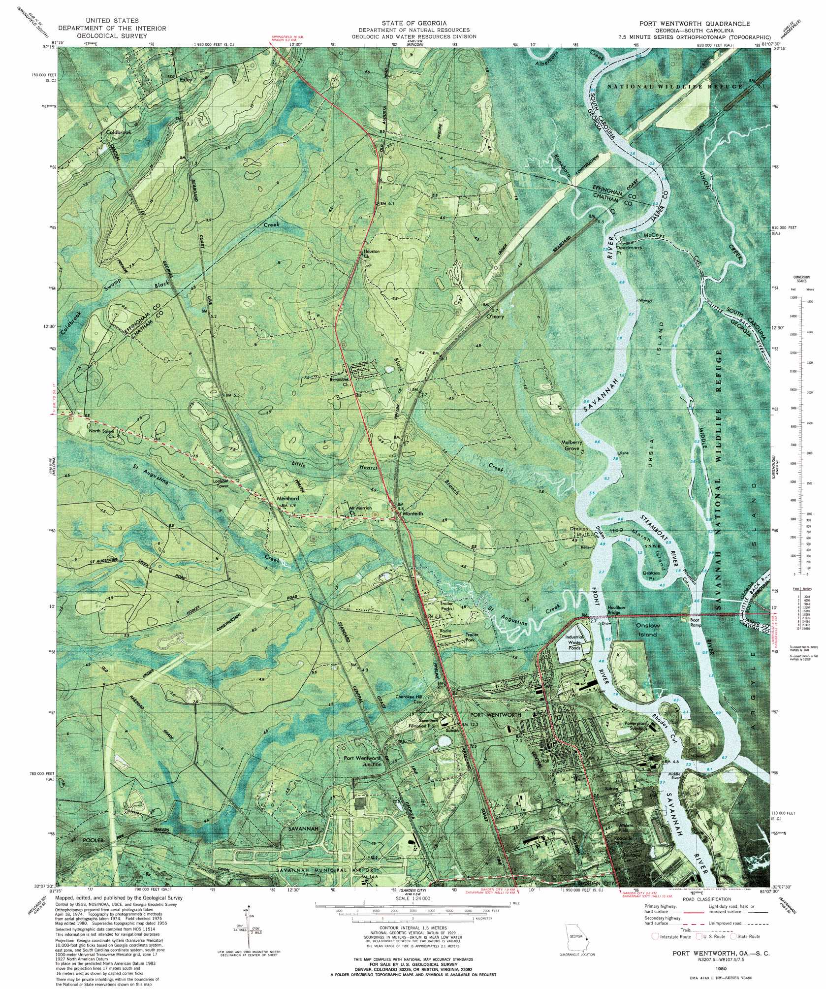
USGS Topo Quad 32081b2 - 1:24,000 scale
| Topo Map Name: | Port Wentworth |
| USGS Topo Quad ID: | 32081b2 |
| Print Size: | ca. 21 1/4" wide x 27" high |
| Southeast Coordinates: | 32.125° N latitude / 81.125° W longitude |
| Map Center Coordinates: | 32.1875° N latitude / 81.1875° W longitude |
| U.S. States: | GA, SC |
| Filename: | o32081b2.jpg |
| Download Map JPG Image: | Port Wentworth topo map 1:24,000 scale |
| Map Type: | Topographic |
| Topo Series: | 7.5´ |
| Map Scale: | 1:24,000 |
| Source of Map Images: | United States Geological Survey (USGS) |
| Alternate Map Versions: |
Port Wentworth GA 1955, updated 1957 Download PDF Buy paper map Port Wentworth GA 1955, updated 1973 Download PDF Buy paper map Port Wentworth GA 1980, updated 1980 Download PDF Buy paper map Port Wentworth GA 1993, updated 1998 Download PDF Buy paper map Port Wentworth GA 2011 Download PDF Buy paper map Port Wentworth GA 2014 Download PDF Buy paper map |
1:24,000 Topo Quads surrounding Port Wentworth
Egypt |
Springfield North |
Hardeeville Nw |
Tillman |
Ridgeland |
Guyton |
Springfield South |
Rincon |
Hardeeville |
Jasper |
Eden |
Meldrim |
Port Wentworth |
Limehouse |
Pritchardville |
Meldrim Sw |
Meldrim Se |
Garden City |
Savannah |
Fort Pulaski |
Limerick Nw |
Richmond Hill |
Burroughs |
Isle Of Hope |
Wassaw Sound |
> Back to 32081a1 at 1:100,000 scale
> Back to 32080a1 at 1:250,000 scale
> Back to U.S. Topo Maps home
Port Wentworth topo map: Gazetteer
Port Wentworth: Airports
Savannah International Airport elevation 11m 36′Port Wentworth: Capes
Deadmans Point elevation 1m 3′Drakies Point elevation 1m 3′
Port Wentworth: Channels
Drakies Cut elevation 0m 0′Houstown Cut elevation 0m 0′
McCoys Cut elevation 2m 6′
Rhodes Cut elevation 0m 0′
Port Wentworth: Cliffs
Drakies Bluff elevation 0m 0′Port Wentworth: Crossings
Exit 19 elevation 7m 22′Port Wentworth: Islands
Argyle Island elevation 1m 3′Hog Marsh Island elevation 1m 3′
Onslow Island elevation 1m 3′
Ursla Island elevation 1m 3′
Port Wentworth: Populated Places
Coldbrook elevation 18m 59′Exley elevation 17m 55′
Meinhard elevation 4m 13′
Monteith elevation 8m 26′
Mulberry Grove elevation 1m 3′
O'Leary elevation 3m 9′
Port Wentworth elevation 7m 22′
Port Wentworth Junction elevation 10m 32′
Port Wentworth: Post Offices
Port Wentworth Post Office elevation 6m 19′Port Wentworth: Streams
Abercorn Creek elevation 0m 0′Black Creek elevation 0m 0′
Front River elevation 0m 0′
Knoxboro Creek elevation 0m 0′
Little Hearst Branch elevation 0m 0′
Middle River elevation 0m 0′
Saint Augustine Creek elevation 0m 0′
Steamboat River elevation 0m 0′
Union Creek elevation 0m 0′
Union Creek elevation 0m 0′
Port Wentworth: Swamps
Coldbrook Swamp elevation 5m 16′Port Wentworth digital topo map on disk
Buy this Port Wentworth topo map showing relief, roads, GPS coordinates and other geographical features, as a high-resolution digital map file on DVD:
South Carolina, Western North Carolina & Northeastern Georgia
Buy digital topo maps: South Carolina, Western North Carolina & Northeastern Georgia