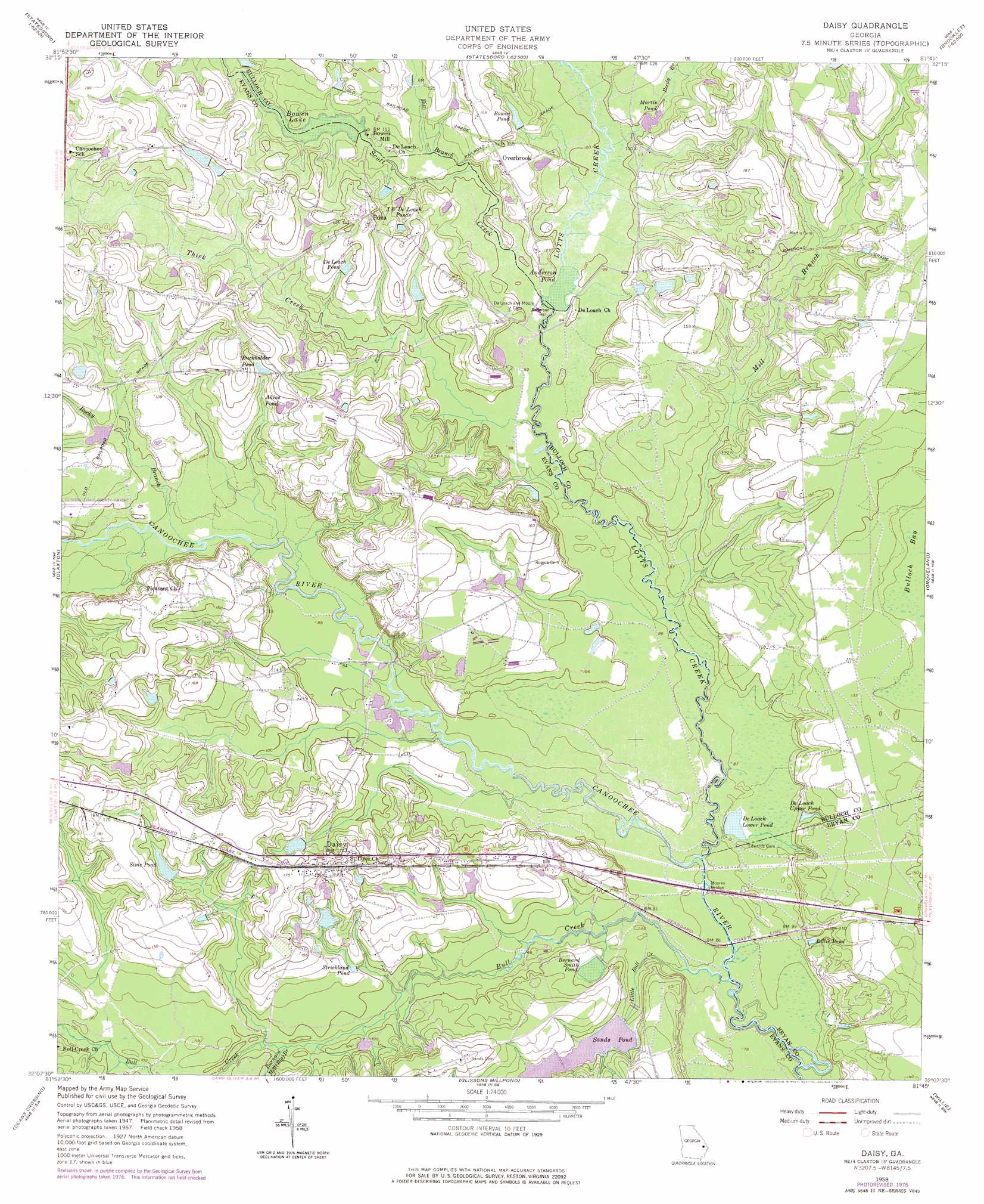
Daisy Topo Map Georgia
To zoom in, hover over the map of Daisy
USGS Topo Quad 32081b7 - 1:24,000 scale
| Topo Map Name: | Daisy |
| USGS Topo Quad ID: | 32081b7 |
| Print Size: | ca. 21 1/4" wide x 27" high |
| Southeast Coordinates: | 32.125° N latitude / 81.75° W longitude |
| Map Center Coordinates: | 32.1875° N latitude / 81.8125° W longitude |
| U.S. State: | GA |
| Filename: | o32081b7.jpg |
| Download Map JPG Image: | Daisy topo map 1:24,000 scale |
| Map Type: | Topographic |
| Topo Series: | 7.5´ |
| Map Scale: | 1:24,000 |
| Source of Map Images: | United States Geological Survey (USGS) |
| Alternate Map Versions: |
Daisy GA 1958, updated 1961 Download PDF Buy paper map Daisy GA 1958, updated 1969 Download PDF Buy paper map Daisy GA 1958, updated 1977 Download PDF Buy paper map Daisy GA 2011 Download PDF Buy paper map Daisy GA 2014 Download PDF Buy paper map |
1:24,000 Topo Quads surrounding Daisy
Metter |
Pulaski |
Statesboro |
Brooklet |
Leefield |
Metter Se |
Register |
Nevils |
Denmark |
Stilson |
Collins |
Claxton |
Daisy |
Groveland |
Lanier |
Reidsville East |
Deans Crossing |
Glissons Millpond |
Willie |
Letford |
Tison |
Glennville |
Glennville Ne |
Taylors Creek |
Trinity |
> Back to 32081a1 at 1:100,000 scale
> Back to 32080a1 at 1:250,000 scale
> Back to U.S. Topo Maps home
Daisy topo map: Gazetteer
Daisy: Airports
Claxton-Evans County Airport elevation 32m 104′Daisy: Bridges
Moores Bridge elevation 21m 68′Mose Hendrix Bridge (historical) elevation 27m 88′
Rogers Bridge elevation 24m 78′
Daisy: Dams
Anderson Pond Dam elevation 29m 95′Bernard Smith Pond Dam elevation 27m 88′
Bowen Lake Dam elevation 32m 104′
Deloach Lower Pond Dam elevation 25m 82′
Evans County Public Lake Dam elevation 29m 95′
Saint Regis Pond Dam elevation 48m 157′
Sims Pond Dam elevation 41m 134′
Daisy: Lakes
Martin Pond elevation 29m 95′Daisy: Populated Places
Anderson Mill elevation 29m 95′Bowen Mill elevation 34m 111′
Daisy elevation 46m 150′
Edna elevation 47m 154′
Mount Pleasant elevation 50m 164′
Overbrook elevation 42m 137′
Palatkee (historical) elevation 27m 88′
Daisy: Post Offices
Daisy Post Office elevation 53m 173′Daisy: Reservoirs
Akins Pond elevation 40m 131′Anderson Pond elevation 29m 95′
Bernard Smith Pond elevation 27m 88′
Billie Pond elevation 29m 95′
Bowen Lake elevation 32m 104′
Bowen Pond elevation 39m 127′
Buckhalder Pond elevation 43m 141′
De Loach Lower Pond elevation 25m 82′
De Loach Pond elevation 40m 131′
De Loach Upper Pond elevation 28m 91′
Deloach Lower Pond elevation 26m 85′
Evans County Public Lake elevation 29m 95′
I W De Loach Ponds elevation 34m 111′
Saint Regis Paper Company Pond elevation 48m 157′
Sands Pond elevation 29m 95′
Sims Pond elevation 41m 134′
Strickland Pond elevation 31m 101′
Strickland Pond (historical) elevation 32m 104′
Daisy: Springs
Magnolia Spring elevation 36m 118′Daisy: Streams
Barnard Mill elevation 27m 88′Big Branch elevation 30m 98′
Bull Creek elevation 18m 59′
Little Bull Creek elevation 19m 62′
Lotts Creek elevation 21m 68′
Mill Branch elevation 24m 78′
Reedy Branch elevation 30m 98′
Rocky Branch elevation 27m 88′
Scott Creek elevation 29m 95′
Thick Creek elevation 27m 88′
Daisy digital topo map on disk
Buy this Daisy topo map showing relief, roads, GPS coordinates and other geographical features, as a high-resolution digital map file on DVD:
South Carolina, Western North Carolina & Northeastern Georgia
Buy digital topo maps: South Carolina, Western North Carolina & Northeastern Georgia