Claxton Topo Map Georgia
To zoom in, hover over the map of Claxton
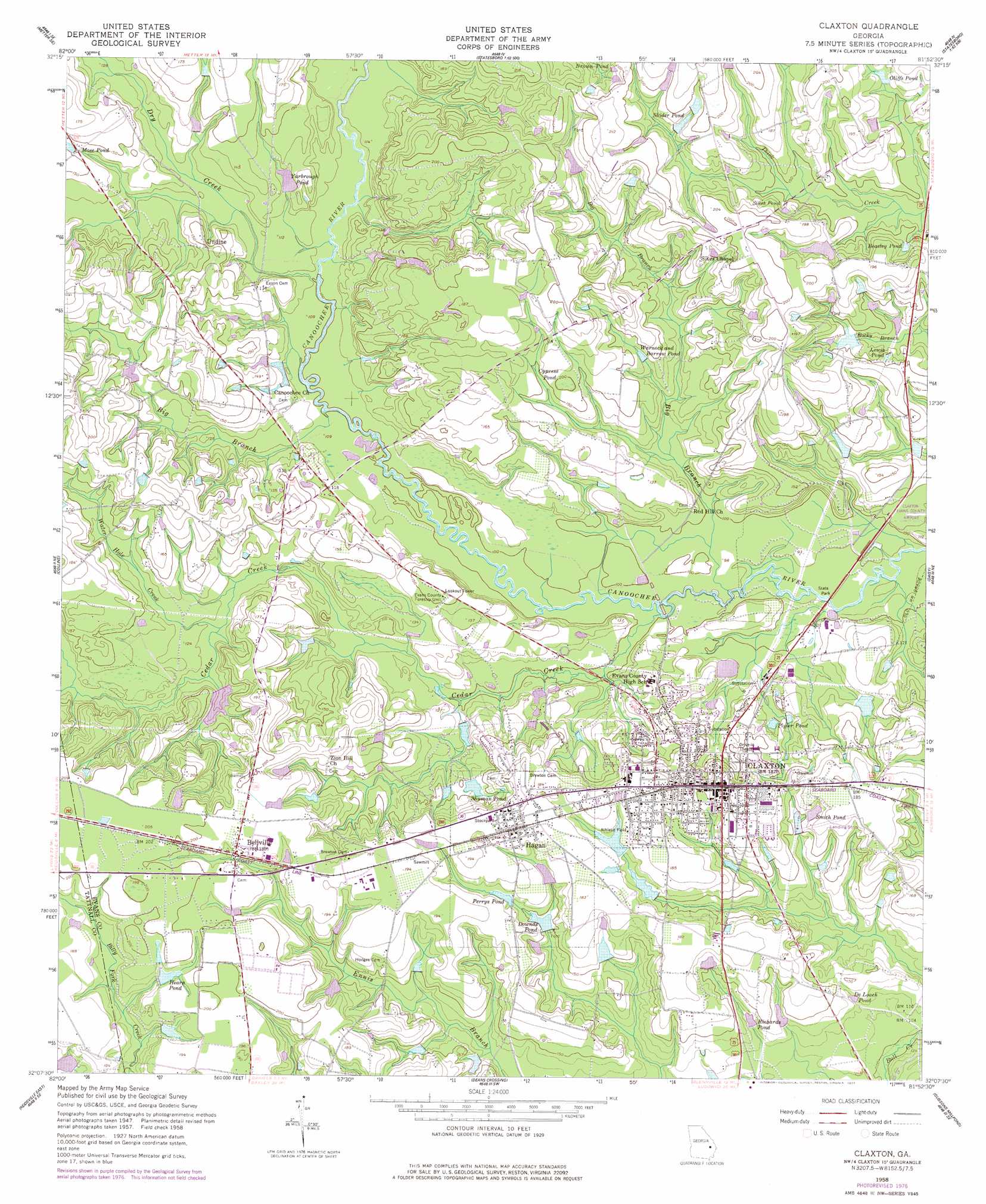
USGS Topo Quad 32081b8 - 1:24,000 scale
| Topo Map Name: | Claxton |
| USGS Topo Quad ID: | 32081b8 |
| Print Size: | ca. 21 1/4" wide x 27" high |
| Southeast Coordinates: | 32.125° N latitude / 81.875° W longitude |
| Map Center Coordinates: | 32.1875° N latitude / 81.9375° W longitude |
| U.S. State: | GA |
| Filename: | o32081b8.jpg |
| Download Map JPG Image: | Claxton topo map 1:24,000 scale |
| Map Type: | Topographic |
| Topo Series: | 7.5´ |
| Map Scale: | 1:24,000 |
| Source of Map Images: | United States Geological Survey (USGS) |
| Alternate Map Versions: |
Claxton GA 1958, updated 1961 Download PDF Buy paper map Claxton GA 1958, updated 1977 Download PDF Buy paper map Claxton GA 2011 Download PDF Buy paper map Claxton GA 2014 Download PDF Buy paper map |
1:24,000 Topo Quads surrounding Claxton
Stillmore |
Metter |
Pulaski |
Statesboro |
Brooklet |
Cobbtown |
Metter Se |
Register |
Nevils |
Denmark |
Ohoopee |
Collins |
Claxton |
Daisy |
Groveland |
Reidsville West |
Reidsville East |
Deans Crossing |
Glissons Millpond |
Willie |
Altamaha |
Tison |
Glennville |
Glennville Ne |
Taylors Creek |
> Back to 32081a1 at 1:100,000 scale
> Back to 32080a1 at 1:250,000 scale
> Back to U.S. Topo Maps home
Claxton topo map: Gazetteer
Claxton: Airports
Hearn Airport elevation 55m 180′Claxton: Bridges
Brewton Bridge elevation 30m 98′Claxton Bridge elevation 28m 91′
Hendrix Bridge elevation 31m 101′
Claxton: Dams
Big Beasley Pond Dam elevation 50m 164′Claxton Sewage Treatment Pond Dam elevation 33m 108′
Rodgers Pond Dam elevation 47m 154′
Rogers Lake Dam elevation 41m 134′
Strickland Dam elevation 47m 154′
Varnadoe Dam elevation 46m 150′
Yarbrough Pond Dam elevation 38m 124′
Claxton: Lakes
Cypress Pond elevation 46m 150′Claxton: Populated Places
Bellville elevation 56m 183′Claxton elevation 56m 183′
Hagan elevation 58m 190′
Lovetts Mobile Home Park elevation 40m 131′
Undine elevation 46m 150′
Claxton: Post Offices
Claxton Post Office elevation 56m 183′Claxton: Reservoirs
Beasley Pond elevation 46m 150′Big Beasley Pond elevation 50m 164′
Brown Pond elevation 56m 183′
Claxton Sewage Treatment Pond elevation 33m 108′
De Loach Pond elevation 38m 124′
Downds Pond elevation 43m 141′
Hearn Pond elevation 56m 183′
Lewis Pond elevation 43m 141′
Mose Pond elevation 42m 137′
Oliffs Pond elevation 49m 160′
Perrys Pond elevation 49m 160′
Plyler Pond elevation 35m 114′
Richards Pond elevation 39m 127′
Rodgers Pond elevation 47m 154′
Rogers Lake elevation 41m 134′
Shider Pond elevation 52m 170′
Shuman Pond elevation 41m 134′
Sikes Pond elevation 48m 157′
Smith Pond elevation 47m 154′
Strickland Lake elevation 47m 154′
Varnadoe Lake elevation 46m 150′
Warnock and Barrow Pond elevation 41m 134′
Yarbrough Pond elevation 38m 124′
Claxton: Streams
Big Branch elevation 30m 98′Big Branch elevation 27m 88′
Cedar Creek elevation 27m 88′
Dry Creek elevation 30m 98′
Water Hole Creek elevation 35m 114′
Claxton digital topo map on disk
Buy this Claxton topo map showing relief, roads, GPS coordinates and other geographical features, as a high-resolution digital map file on DVD:
South Carolina, Western North Carolina & Northeastern Georgia
Buy digital topo maps: South Carolina, Western North Carolina & Northeastern Georgia