Statesboro Topo Map Georgia
To zoom in, hover over the map of Statesboro
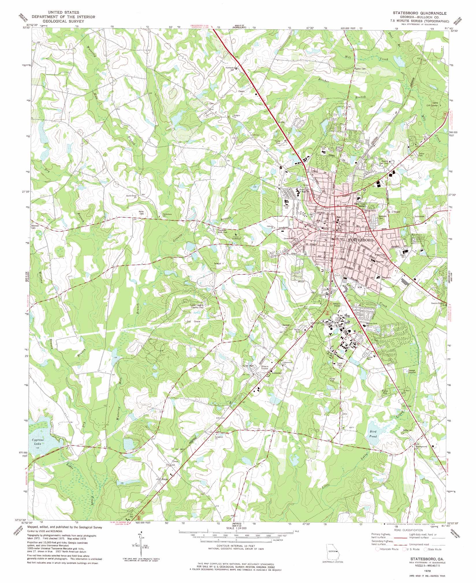
USGS Topo Quad 32081d7 - 1:24,000 scale
| Topo Map Name: | Statesboro |
| USGS Topo Quad ID: | 32081d7 |
| Print Size: | ca. 21 1/4" wide x 27" high |
| Southeast Coordinates: | 32.375° N latitude / 81.75° W longitude |
| Map Center Coordinates: | 32.4375° N latitude / 81.8125° W longitude |
| U.S. State: | GA |
| Filename: | o32081d7.jpg |
| Download Map JPG Image: | Statesboro topo map 1:24,000 scale |
| Map Type: | Topographic |
| Topo Series: | 7.5´ |
| Map Scale: | 1:24,000 |
| Source of Map Images: | United States Geological Survey (USGS) |
| Alternate Map Versions: |
Statesboro GA 1978, updated 1978 Download PDF Buy paper map Statesboro GA 1993, updated 1998 Download PDF Buy paper map Statesboro GA 2011 Download PDF Buy paper map Statesboro GA 2014 Download PDF Buy paper map |
1:24,000 Topo Quads surrounding Statesboro
Garfield |
Four Points |
Rocky Ford |
Sylvania South |
Hunters |
Twin City Se |
Portal |
Hopeulikit |
Dover |
Oliver |
Metter |
Pulaski |
Statesboro |
Brooklet |
Leefield |
Metter Se |
Register |
Nevils |
Denmark |
Stilson |
Collins |
Claxton |
Daisy |
Groveland |
Lanier |
> Back to 32081a1 at 1:100,000 scale
> Back to 32080a1 at 1:250,000 scale
> Back to U.S. Topo Maps home
Statesboro topo map: Gazetteer
Statesboro: Areas
Sweatheart Circle elevation 74m 242′Williams Concourse elevation 73m 239′
Statesboro: Dams
Altman Pond Dam elevation 71m 232′Cypress Lake Dam elevation 45m 147′
H Z Smith Lake Dam elevation 62m 203′
Hood Pond Dam elevation 46m 150′
Mallard Pond Dam elevation 59m 193′
Riggs Lake Dam elevation 50m 164′
Riggs Pond Dam elevation 44m 144′
Smith Lake Dam elevation 68m 223′
Statesboro: Lakes
Bird Pond elevation 53m 173′Cypress Lake elevation 45m 147′
Statesboro: Parks
Arena Park elevation 68m 223′Blitch State Park elevation 72m 236′
Charles H Herty Pines Nature Preserve elevation 66m 216′
East Main Street Commercial Historic District elevation 76m 249′
Fair Road Park elevation 64m 209′
J I Clements Stadium elevation 69m 226′
North College Street Residential Historic District elevation 71m 232′
North Main Street Commercial Historic District elevation 78m 255′
Olewine Park elevation 71m 232′
Paulson Stadium elevation 64m 209′
Pinelawn Memorial Park elevation 57m 187′
South Main Street Commercial Historic District elevation 77m 252′
South Main Street Residential Historic District elevation 72m 236′
W Jones Lane Memorial Park elevation 64m 209′
West Main Street Commercial Historic District elevation 75m 246′
Statesboro: Populated Places
Belair Estates elevation 67m 219′Bird Mobile Home Park elevation 58m 190′
Colfax (historical) elevation 76m 249′
Country Club Estates elevation 65m 213′
Country Club Hills elevation 65m 213′
Country Squire elevation 70m 229′
Deerfield elevation 58m 190′
Eagle Court elevation 62m 203′
Edgewood Acres elevation 62m 203′
Forest Heights elevation 69m 226′
Forest Hills elevation 77m 252′
Foxlake elevation 69m 226′
Georgia Southern elevation 64m 209′
Georgian Walk elevation 48m 157′
Greenbriar elevation 65m 213′
Greenhaven Mobile Home Park elevation 55m 180′
Greenwood elevation 63m 206′
Hazelwood elevation 67m 219′
Hillside Mobile Home Park elevation 60m 196′
Horseshoe Bend elevation 57m 187′
Huntington elevation 53m 173′
Inglewood elevation 70m 229′
Irongate elevation 62m 203′
Jimps elevation 61m 200′
Johnsons Mobile Court elevation 60m 196′
Kingswood elevation 70m 229′
Lakeview Estates elevation 71m 232′
Lynn Haven Estates elevation 72m 236′
Northlake elevation 61m 200′
Northpoint Mobile Home Park elevation 58m 190′
Northwood elevation 57m 187′
Oakcrest elevation 62m 203′
Olde Towne elevation 61m 200′
Pate Place elevation 59m 193′
Pine Cove elevation 72m 236′
Pine Forest elevation 57m 187′
Pine Needle Hills elevation 76m 249′
Quail Run elevation 68m 223′
Ramblewood East elevation 67m 219′
Saddlecreek elevation 59m 193′
Sherwood Forest elevation 62m 203′
Somerset elevation 61m 200′
Stadium Club elevation 63m 206′
Stadium Walk elevation 65m 213′
Statesboro elevation 77m 252′
Sussex Commons elevation 64m 209′
Westbrooke elevation 77m 252′
Westchester elevation 65m 213′
Wolf Pen Mobile Home Park elevation 44m 144′
Woodland Mobile Estates elevation 67m 219′
Woodlawn Terrace elevation 59m 193′
Statesboro: Post Offices
Statesboro Post Office elevation 78m 255′Statesboro: Reservoirs
Altman Pond elevation 71m 232′H Z Smith Lake elevation 62m 203′
Hood Pond elevation 46m 150′
Lake Ruby elevation 66m 216′
Lake Wells elevation 65m 213′
Mallard Pond elevation 59m 193′
Riggs Lake elevation 50m 164′
Riggs Pond elevation 44m 144′
Robinson Pond (historical) elevation 48m 157′
Smith Lake elevation 68m 223′
Statesboro: Streams
Belcher Branch elevation 45m 147′Deal Branch elevation 46m 150′
Dry Branch elevation 42m 137′
Granna Branch elevation 51m 167′
Watering Hole Branch elevation 42m 137′
Wolfpen Branch elevation 46m 150′
Statesboro digital topo map on disk
Buy this Statesboro topo map showing relief, roads, GPS coordinates and other geographical features, as a high-resolution digital map file on DVD:
South Carolina, Western North Carolina & Northeastern Georgia
Buy digital topo maps: South Carolina, Western North Carolina & Northeastern Georgia