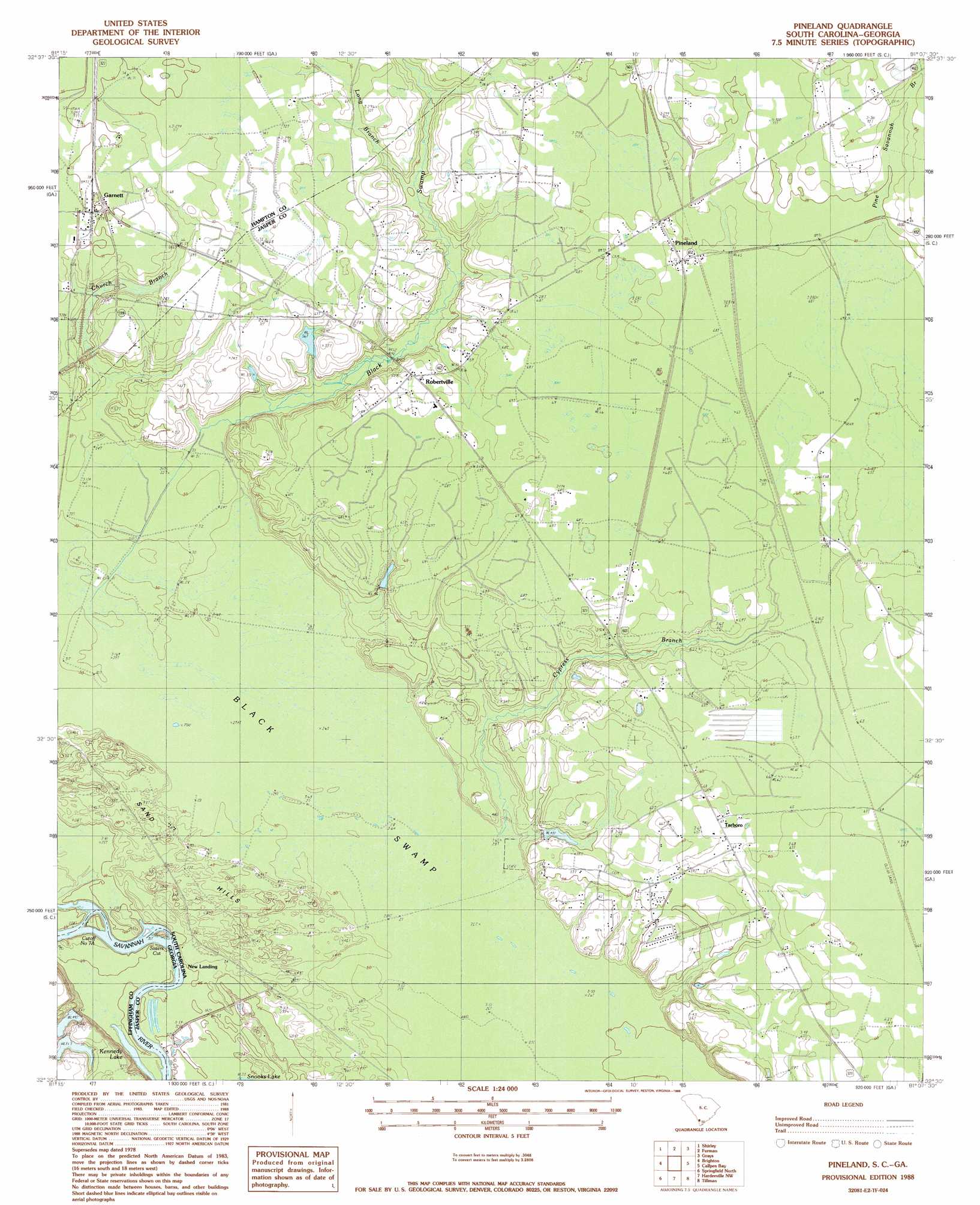
Pineland Topo Map South Carolina
To zoom in, hover over the map of Pineland
USGS Topo Quad 32081e2 - 1:24,000 scale
| Topo Map Name: | Pineland |
| USGS Topo Quad ID: | 32081e2 |
| Print Size: | ca. 21 1/4" wide x 27" high |
| Southeast Coordinates: | 32.5° N latitude / 81.125° W longitude |
| Map Center Coordinates: | 32.5625° N latitude / 81.1875° W longitude |
| U.S. States: | SC, GA |
| Filename: | o32081e2.jpg |
| Download Map JPG Image: | Pineland topo map 1:24,000 scale |
| Map Type: | Topographic |
| Topo Series: | 7.5´ |
| Map Scale: | 1:24,000 |
| Source of Map Images: | United States Geological Survey (USGS) |
| Alternate Map Versions: |
Pineland SC 1978, updated 1978 Download PDF Buy paper map Pineland SC 1988, updated 1988 Download PDF Buy paper map Pineland SC 2011 Download PDF Buy paper map Pineland SC 2014 Download PDF Buy paper map |
1:24,000 Topo Quads surrounding Pineland
Brier Creek Landing |
Solomons Crossroads |
Gifford |
Hampton |
Cummings |
Blue Springs Landing |
Shirley |
Furman |
Grays |
Mcphersonville |
Kildare |
Brighton |
Pineland |
Calfpen Bay |
Coosawhatchie |
Egypt |
Springfield North |
Hardeeville Nw |
Tillman |
Ridgeland |
Guyton |
Springfield South |
Rincon |
Hardeeville |
Jasper |
> Back to 32081e1 at 1:100,000 scale
> Back to 32080a1 at 1:250,000 scale
> Back to U.S. Topo Maps home
Pineland topo map: Gazetteer
Pineland: Bends
Cutoff Number 7a elevation 5m 16′Cutoff Number 7-A elevation 8m 26′
Sisters Cut elevation 8m 26′
Pineland: Crossings
Dupies Ferry (historical) elevation 5m 16′Dupies Ferry (historical) elevation 5m 16′
Two Sisters Ferry (historical) elevation 5m 16′
Two Sisters Ferry (historical) elevation 5m 16′
Pineland: Dams
South Carolina Noname 27001 D-2587 Dam elevation 9m 29′Pineland: Lakes
Kennedy Lake elevation 5m 16′Pineland: Populated Places
Cosby elevation 13m 42′Garnett elevation 23m 75′
New Landing elevation 7m 22′
Pineland elevation 21m 68′
Robertville elevation 20m 65′
Tarboro elevation 20m 65′
Pineland: Post Offices
Garnett Post Office elevation 23m 75′Pineland: Reservoirs
Baxter Pond elevation 9m 29′Pineland: Ridges
Sand Hills elevation 11m 36′Pineland: Streams
Black Swamp elevation 10m 32′Church Branch elevation 10m 32′
Cypress Branch elevation 8m 26′
Long Branch elevation 15m 49′
Pine Savannah Branch elevation 26m 85′
Pineland: Swamps
Black Swamp elevation 9m 29′Pineland digital topo map on disk
Buy this Pineland topo map showing relief, roads, GPS coordinates and other geographical features, as a high-resolution digital map file on DVD:
South Carolina, Western North Carolina & Northeastern Georgia
Buy digital topo maps: South Carolina, Western North Carolina & Northeastern Georgia