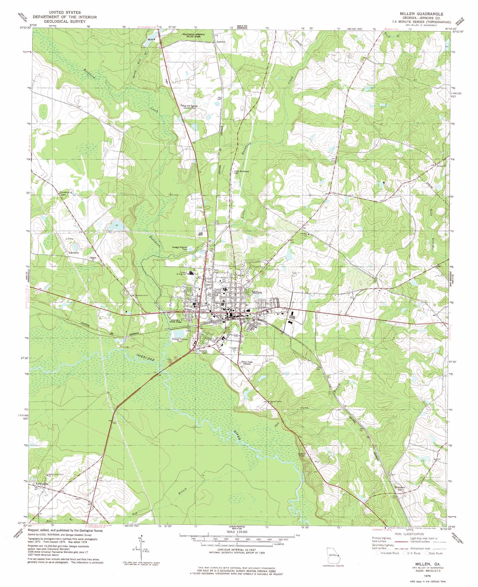
Millen Topo Map Georgia
To zoom in, hover over the map of Millen
USGS Topo Quad 32081g8 - 1:24,000 scale
| Topo Map Name: | Millen |
| USGS Topo Quad ID: | 32081g8 |
| Print Size: | ca. 21 1/4" wide x 27" high |
| Southeast Coordinates: | 32.75° N latitude / 81.875° W longitude |
| Map Center Coordinates: | 32.8125° N latitude / 81.9375° W longitude |
| U.S. State: | GA |
| Filename: | o32081g8.jpg |
| Download Map JPG Image: | Millen topo map 1:24,000 scale |
| Map Type: | Topographic |
| Topo Series: | 7.5´ |
| Map Scale: | 1:24,000 |
| Source of Map Images: | United States Geological Survey (USGS) |
| Alternate Map Versions: |
Millen GA 1978, updated 1978 Download PDF Buy paper map Millen GA 2011 Download PDF Buy paper map Millen GA 2014 Download PDF Buy paper map |
1:24,000 Topo Quads surrounding Millen
Gough |
Waynesboro |
Idlewood |
Alexander |
Girard |
Scotts Corner |
Bellevue |
Perkins |
Sardis |
Hilltonia |
Midville |
Birdsville |
Millen |
Bay Branch |
Sylvania North |
Canoochee |
Garfield |
Four Points |
Rocky Ford |
Sylvania South |
Twin City |
Twin City Se |
Portal |
Hopeulikit |
Dover |
> Back to 32081e1 at 1:100,000 scale
> Back to 32080a1 at 1:250,000 scale
> Back to U.S. Topo Maps home
Millen topo map: Gazetteer
Millen: Dams
Davis Lake Dam elevation 48m 157′Millen View Lake Dam elevation 67m 219′
Millen: Parks
Lincoln State Park elevation 42m 137′Millen: Populated Places
Emmalane elevation 62m 203′Lawton elevation 66m 216′
Millen elevation 51m 167′
Paramore Hill elevation 76m 249′
South Millen (historical) elevation 46m 150′
Millen: Post Offices
Millen Post Office elevation 52m 170′Millen: Reservoirs
Davis Lake elevation 48m 157′Millen View Lake elevation 67m 219′
Millen: Streams
Bay Branch elevation 41m 134′Buckhead Creek elevation 41m 134′
Little Buckhead Creek elevation 43m 141′
Oak Cane Branch elevation 41m 134′
Spring Mill Branch elevation 45m 147′
Millen: Summits
Paramore Hill elevation 86m 282′Millen digital topo map on disk
Buy this Millen topo map showing relief, roads, GPS coordinates and other geographical features, as a high-resolution digital map file on DVD:
South Carolina, Western North Carolina & Northeastern Georgia
Buy digital topo maps: South Carolina, Western North Carolina & Northeastern Georgia