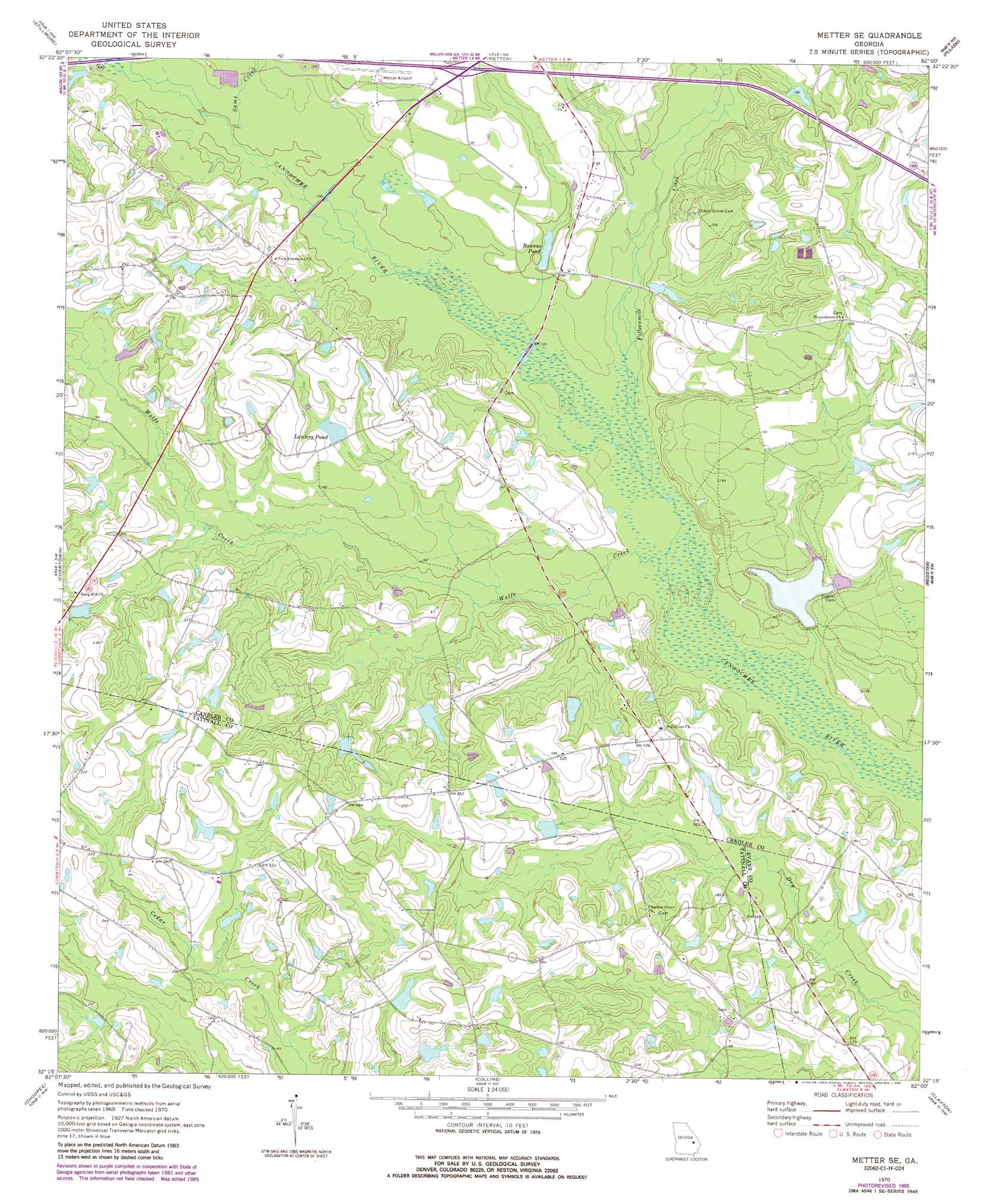
Metter Se Topo Map Georgia
To zoom in, hover over the map of Metter Se
USGS Topo Quad 32082c1 - 1:24,000 scale
| Topo Map Name: | Metter Se |
| USGS Topo Quad ID: | 32082c1 |
| Print Size: | ca. 21 1/4" wide x 27" high |
| Southeast Coordinates: | 32.25° N latitude / 82° W longitude |
| Map Center Coordinates: | 32.3125° N latitude / 82.0625° W longitude |
| U.S. State: | GA |
| Filename: | o32082c1.jpg |
| Download Map JPG Image: | Metter Se topo map 1:24,000 scale |
| Map Type: | Topographic |
| Topo Series: | 7.5´ |
| Map Scale: | 1:24,000 |
| Source of Map Images: | United States Geological Survey (USGS) |
| Alternate Map Versions: |
Metter SE GA 1970, updated 1973 Download PDF Buy paper map Metter SE GA 1970, updated 1986 Download PDF Buy paper map Metter SE GA 2011 Download PDF Buy paper map Metter SE GA 2014 Download PDF Buy paper map |
1:24,000 Topo Quads surrounding Metter Se
Swainsboro |
Twin City |
Twin City Se |
Portal |
Hopeulikit |
Nunez |
Stillmore |
Metter |
Pulaski |
Statesboro |
Oak Park |
Cobbtown |
Metter Se |
Register |
Nevils |
Lyons |
Ohoopee |
Collins |
Claxton |
Daisy |
Johnson Corner |
Reidsville West |
Reidsville East |
Deans Crossing |
Glissons Millpond |
> Back to 32082a1 at 1:100,000 scale
> Back to 32082a1 at 1:250,000 scale
> Back to U.S. Topo Maps home
Metter Se topo map: Gazetteer
Metter Se: Airports
Metter Municipal Airport elevation 59m 193′Metter Se: Bridges
Cowart Bridge elevation 45m 147′Dutch Ford Bridge elevation 42m 137′
Flat Ford Bridge elevation 45m 147′
Green Bridge elevation 42m 137′
Turner Bridge elevation 45m 147′
Metter Se: Crossings
Exit 23 elevation 54m 177′Metter Se: Dams
Brannen Lake Dam elevation 43m 141′Callaway Pond Dam elevation 66m 216′
Daniels Lake Dam elevation 52m 170′
Glisson Lake Dam elevation 56m 183′
Hensley Lake Dam elevation 70m 229′
Laniers Pond Dam elevation 54m 177′
West Lake Dam elevation 53m 173′
Metter Se: Reservoirs
Bowens Pond elevation 45m 147′Brannen Lake elevation 43m 141′
Callaway Pond elevation 66m 216′
Daniels Lake elevation 52m 170′
Glisson Lake elevation 56m 183′
Hensley Lake elevation 70m 229′
Laniers Pond elevation 54m 177′
West Lake elevation 53m 173′
Metter Se: Streams
Fifteenmile Creek elevation 40m 131′Sams Creek elevation 45m 147′
Wolfe Creek elevation 42m 137′
Metter Se digital topo map on disk
Buy this Metter Se topo map showing relief, roads, GPS coordinates and other geographical features, as a high-resolution digital map file on DVD:
South Carolina, Western North Carolina & Northeastern Georgia
Buy digital topo maps: South Carolina, Western North Carolina & Northeastern Georgia