Oak Park Sw Topo Map Georgia
To zoom in, hover over the map of Oak Park Sw
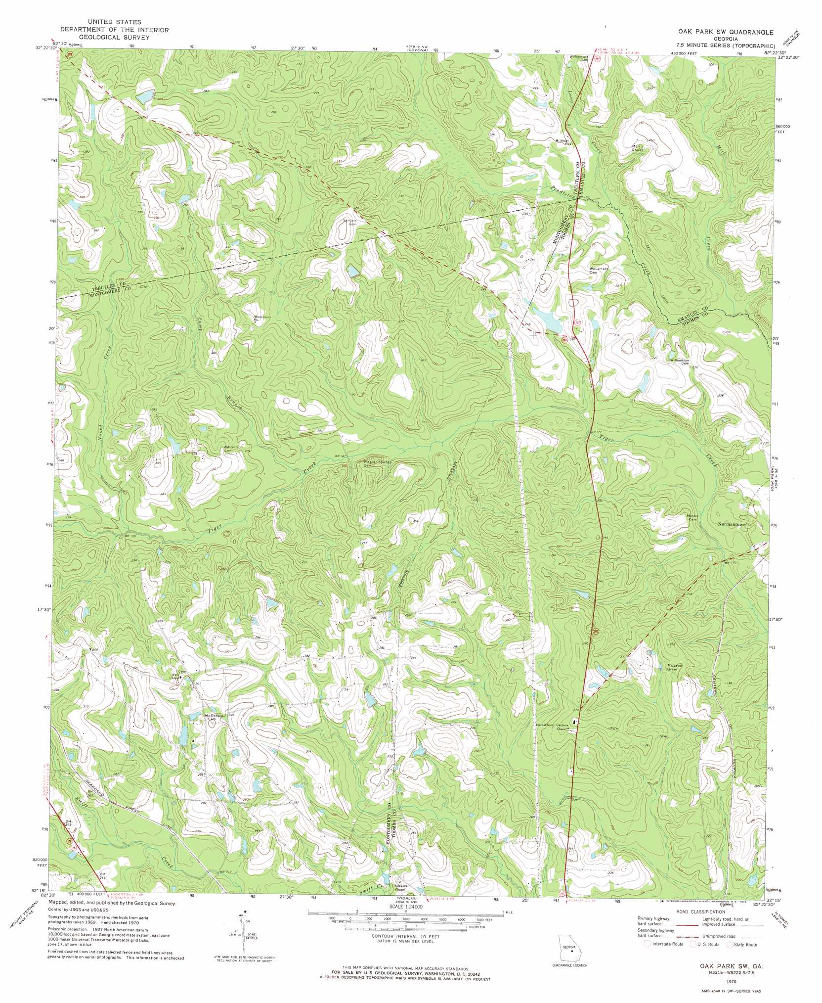
USGS Topo Quad 32082c4 - 1:24,000 scale
| Topo Map Name: | Oak Park Sw |
| USGS Topo Quad ID: | 32082c4 |
| Print Size: | ca. 21 1/4" wide x 27" high |
| Southeast Coordinates: | 32.25° N latitude / 82.375° W longitude |
| Map Center Coordinates: | 32.3125° N latitude / 82.4375° W longitude |
| U.S. State: | GA |
| Filename: | o32082c4.jpg |
| Download Map JPG Image: | Oak Park Sw topo map 1:24,000 scale |
| Map Type: | Topographic |
| Topo Series: | 7.5´ |
| Map Scale: | 1:24,000 |
| Source of Map Images: | United States Geological Survey (USGS) |
| Alternate Map Versions: |
Oak Park SW GA 1970, updated 1973 Download PDF Buy paper map Oak Park SW GA 2011 Download PDF Buy paper map Oak Park SW GA 2014 Download PDF Buy paper map |
1:24,000 Topo Quads surrounding Oak Park Sw
Scott |
Adrian |
Norristown |
Swainsboro |
Twin City |
Rockledge |
Soperton North |
Covena |
Nunez |
Stillmore |
Lothair |
Soperton South |
Oak Park Sw |
Oak Park |
Cobbtown |
Glenwood |
Mount Vernon |
Vidalia |
Lyons |
Ohoopee |
Jordan |
Uvalda |
Alston |
Johnson Corner |
Reidsville West |
> Back to 32082a1 at 1:100,000 scale
> Back to 32082a1 at 1:250,000 scale
> Back to U.S. Topo Maps home
Oak Park Sw topo map: Gazetteer
Oak Park Sw: Bridges
Holmes Bridge elevation 51m 167′Oak Park Sw: Dams
Rice Lake Dam elevation 65m 213′Oak Park Sw: Reservoirs
Price Pond elevation 94m 308′Rice Lake elevation 65m 213′
Oak Park Sw: Streams
Camp Branch elevation 56m 183′Long Creek elevation 51m 167′
Mill Creek elevation 48m 157′
Naked Creek elevation 58m 190′
Water Prong elevation 67m 219′
Oak Park Sw digital topo map on disk
Buy this Oak Park Sw topo map showing relief, roads, GPS coordinates and other geographical features, as a high-resolution digital map file on DVD:
South Carolina, Western North Carolina & Northeastern Georgia
Buy digital topo maps: South Carolina, Western North Carolina & Northeastern Georgia