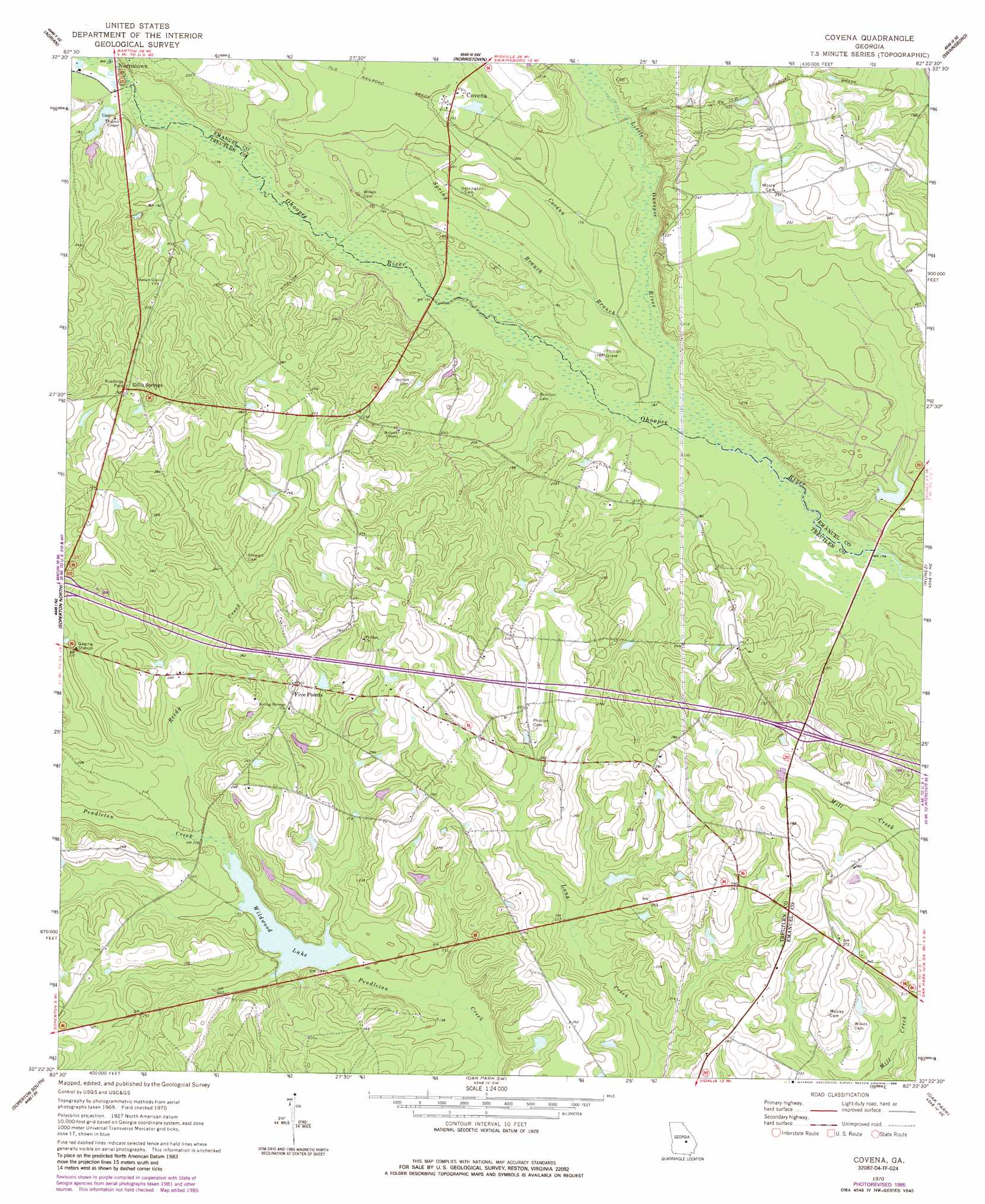
Covena Topo Map Georgia
To zoom in, hover over the map of Covena
USGS Topo Quad 32082d4 - 1:24,000 scale
| Topo Map Name: | Covena |
| USGS Topo Quad ID: | 32082d4 |
| Print Size: | ca. 21 1/4" wide x 27" high |
| Southeast Coordinates: | 32.375° N latitude / 82.375° W longitude |
| Map Center Coordinates: | 32.4375° N latitude / 82.4375° W longitude |
| U.S. State: | GA |
| Filename: | o32082d4.jpg |
| Download Map JPG Image: | Covena topo map 1:24,000 scale |
| Map Type: | Topographic |
| Topo Series: | 7.5´ |
| Map Scale: | 1:24,000 |
| Source of Map Images: | United States Geological Survey (USGS) |
| Alternate Map Versions: |
Covena GA 1970, updated 1973 Download PDF Buy paper map Covena GA 1970, updated 1986 Download PDF Buy paper map Covena GA 2011 Download PDF Buy paper map Covena GA 2014 Download PDF Buy paper map |
1:24,000 Topo Quads surrounding Covena
Wrightsville |
Kite |
Dellwood |
Summertown |
Canoochee |
Scott |
Adrian |
Norristown |
Swainsboro |
Twin City |
Rockledge |
Soperton North |
Covena |
Nunez |
Stillmore |
Lothair |
Soperton South |
Oak Park Sw |
Oak Park |
Cobbtown |
Glenwood |
Mount Vernon |
Vidalia |
Lyons |
Ohoopee |
> Back to 32082a1 at 1:100,000 scale
> Back to 32082a1 at 1:250,000 scale
> Back to U.S. Topo Maps home
Covena topo map: Gazetteer
Covena: Crossings
Exit 20 elevation 74m 242′Covena: Dams
Dykes Pond Dam elevation 76m 249′Paulk Lake Dam elevation 69m 226′
Smith Lake Dam elevation 53m 173′
Trumell Pond Dam elevation 82m 269′
Wildwood Lake Dam elevation 59m 193′
Covena: Populated Places
Covena elevation 63m 206′Five Points elevation 91m 298′
Gillis Springs elevation 91m 298′
Covena: Reservoirs
Courson Pond elevation 76m 249′Dykes Pond elevation 76m 249′
Paulk Dam elevation 69m 226′
Smith Lake elevation 53m 173′
Sumner Pond elevation 56m 183′
Trumell Pond elevation 82m 269′
Wildwood Lake elevation 59m 193′
Covena: Streams
Covena Branch elevation 50m 164′Little Ohoopee River elevation 49m 160′
Reedy Creek elevation 60m 196′
Spring Branch elevation 52m 170′
Thigpen Creek elevation 54m 177′
Thigpen Mill Creek elevation 57m 187′
Covena digital topo map on disk
Buy this Covena topo map showing relief, roads, GPS coordinates and other geographical features, as a high-resolution digital map file on DVD:
South Carolina, Western North Carolina & Northeastern Georgia
Buy digital topo maps: South Carolina, Western North Carolina & Northeastern Georgia