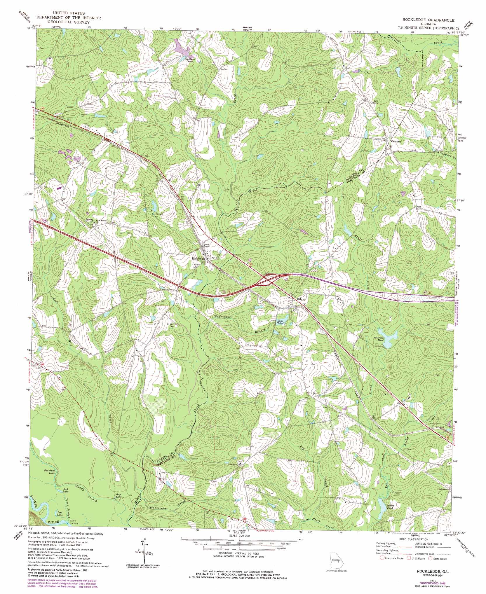
Rockledge Topo Map Georgia
To zoom in, hover over the map of Rockledge
USGS Topo Quad 32082d6 - 1:24,000 scale
| Topo Map Name: | Rockledge |
| USGS Topo Quad ID: | 32082d6 |
| Print Size: | ca. 21 1/4" wide x 27" high |
| Southeast Coordinates: | 32.375° N latitude / 82.625° W longitude |
| Map Center Coordinates: | 32.4375° N latitude / 82.6875° W longitude |
| U.S. State: | GA |
| Filename: | o32082d6.jpg |
| Download Map JPG Image: | Rockledge topo map 1:24,000 scale |
| Map Type: | Topographic |
| Topo Series: | 7.5´ |
| Map Scale: | 1:24,000 |
| Source of Map Images: | United States Geological Survey (USGS) |
| Alternate Map Versions: |
Rockledge GA 1971, updated 1974 Download PDF Buy paper map Rockledge GA 1971, updated 1986 Download PDF Buy paper map Rockledge GA 2011 Download PDF Buy paper map Rockledge GA 2014 Download PDF Buy paper map |
1:24,000 Topo Quads surrounding Rockledge
Cow Hell Swamp |
Lovett |
Wrightsville |
Kite |
Dellwood |
Dublin |
East Dublin |
Scott |
Adrian |
Norristown |
Rentz |
Minter |
Rockledge |
Soperton North |
Covena |
Five Points |
Lowery |
Lothair |
Soperton South |
Oak Park Sw |
Mcrae Nw |
Alamo |
Glenwood |
Mount Vernon |
Vidalia |
> Back to 32082a1 at 1:100,000 scale
> Back to 32082a1 at 1:250,000 scale
> Back to U.S. Topo Maps home
Rockledge topo map: Gazetteer
Rockledge: Crossings
Exit 17 elevation 85m 278′Mercer Ford elevation 45m 147′
Rockledge: Dams
Grahams Pond Dam elevation 76m 249′Lake Helen Dam elevation 81m 265′
Peterson Pond Dam elevation 68m 223′
Rockledge: Lakes
Beacham Lake elevation 45m 147′Gay Lake elevation 46m 150′
Graham Ponds elevation 76m 249′
Jack Lake elevation 45m 147′
Jam Lake elevation 44m 144′
Lake Helen elevation 81m 265′
Miller Pond elevation 59m 193′
Rockledge: Populated Places
Orianna elevation 104m 341′Orland elevation 85m 278′
Rockledge elevation 66m 216′
Rockledge: Reservoirs
Graham Pond elevation 78m 255′Lake Helen elevation 82m 269′
Peterson Pond elevation 68m 223′
Rockledge: Streams
Big Branch elevation 54m 177′Cross Slough elevation 44m 144′
Elias Branch elevation 65m 213′
Hurricane Branch elevation 54m 177′
Hurricane Creek elevation 45m 147′
Muddy Slough elevation 44m 144′
Red Hill Creek elevation 45m 147′
Rocky Creek elevation 59m 193′
Rockledge digital topo map on disk
Buy this Rockledge topo map showing relief, roads, GPS coordinates and other geographical features, as a high-resolution digital map file on DVD:
South Carolina, Western North Carolina & Northeastern Georgia
Buy digital topo maps: South Carolina, Western North Carolina & Northeastern Georgia