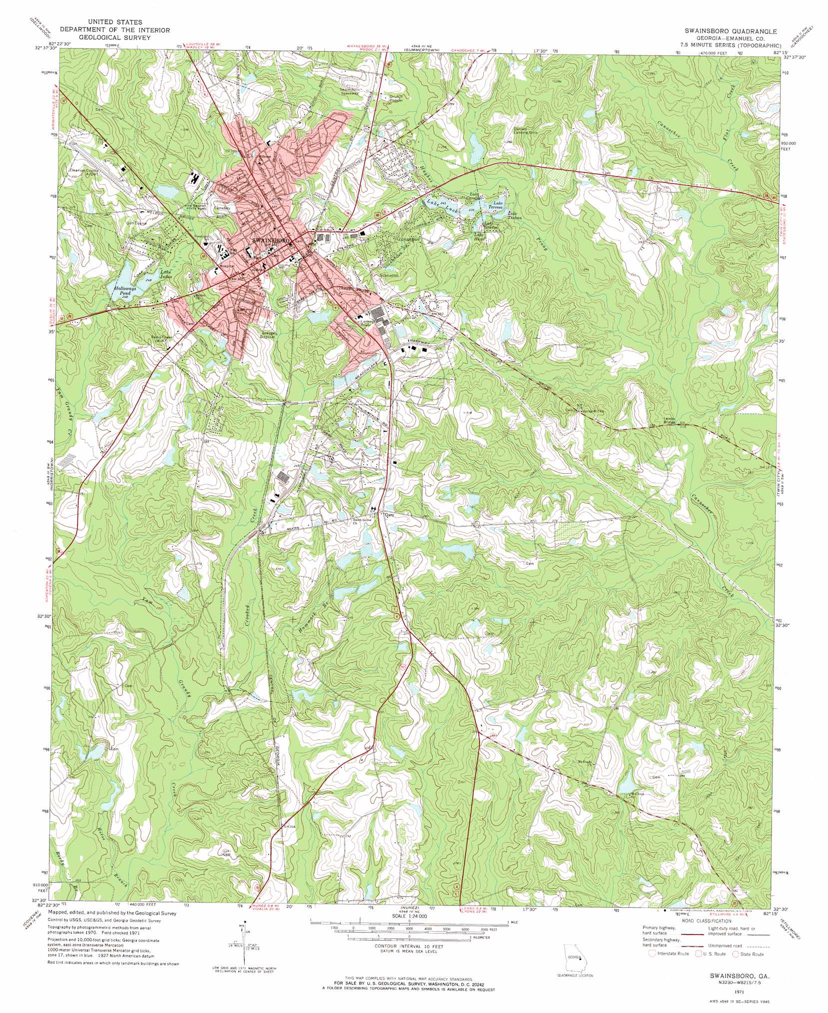
Swainsboro Topo Map Georgia
To zoom in, hover over the map of Swainsboro
USGS Topo Quad 32082e3 - 1:24,000 scale
| Topo Map Name: | Swainsboro |
| USGS Topo Quad ID: | 32082e3 |
| Print Size: | ca. 21 1/4" wide x 27" high |
| Southeast Coordinates: | 32.5° N latitude / 82.25° W longitude |
| Map Center Coordinates: | 32.5625° N latitude / 82.3125° W longitude |
| U.S. State: | GA |
| Filename: | o32082e3.jpg |
| Download Map JPG Image: | Swainsboro topo map 1:24,000 scale |
| Map Type: | Topographic |
| Topo Series: | 7.5´ |
| Map Scale: | 1:24,000 |
| Source of Map Images: | United States Geological Survey (USGS) |
| Alternate Map Versions: |
Swainsboro GA 1971, updated 1973 Download PDF Buy paper map Swainsboro GA 2011 Download PDF Buy paper map Swainsboro GA 2014 Download PDF Buy paper map |
1:24,000 Topo Quads surrounding Swainsboro
Davisboro Se |
Wadley |
Colemans Lake |
Midville |
Birdsville |
Kite |
Dellwood |
Summertown |
Canoochee |
Garfield |
Adrian |
Norristown |
Swainsboro |
Twin City |
Twin City Se |
Soperton North |
Covena |
Nunez |
Stillmore |
Metter |
Soperton South |
Oak Park Sw |
Oak Park |
Cobbtown |
Metter Se |
> Back to 32082e1 at 1:100,000 scale
> Back to 32082a1 at 1:250,000 scale
> Back to U.S. Topo Maps home
Swainsboro topo map: Gazetteer
Swainsboro: Airports
Daniels Airport elevation 85m 278′Emanuel County Airport elevation 98m 321′
Swainsboro: Bridges
Lambs Bridge elevation 62m 203′Swainsboro: Dams
Coleman Lake Dam elevation 65m 213′Daniels Pond Dam elevation 73m 239′
Edenfield Lake Dam elevation 76m 249′
Halloways Pond Dam elevation 75m 246′
Lake Luck Dam elevation 72m 236′
Riner Dam West elevation 74m 242′
Riner Lake Dam elevation 83m 272′
Riner Lake North Dam elevation 62m 203′
Roland Lake Dam elevation 77m 252′
Watson Dam elevation 79m 259′
Youmans Lake Dam elevation 80m 262′
Swainsboro: Parks
Yam Grandy State Park elevation 81m 265′Swainsboro: Populated Places
Gary elevation 95m 311′Kirby elevation 82m 269′
Swainsboro elevation 99m 324′
Swainsboro: Post Offices
Swainsboro Post Office elevation 96m 314′Swainsboro: Reservoirs
Coleman Lake elevation 65m 213′Daniels Pond elevation 73m 239′
Edenfield Lake elevation 76m 249′
Gradys Lake elevation 70m 229′
Halloways Pond elevation 75m 246′
Hazel Lake elevation 74m 242′
Holloways Pond elevation 75m 246′
Lake Caroline elevation 68m 223′
Lake India elevation 75m 246′
Lake Luck elevation 72m 236′
Lake Terresa elevation 68m 223′
Lake Thelma elevation 67m 219′
Riner Lake elevation 83m 272′
Riner Lake North elevation 62m 203′
Riner Lake West elevation 74m 242′
Roland Lake elevation 77m 252′
Watson Lake elevation 79m 259′
Youmans Lake elevation 80m 262′
Swainsboro: Streams
Crooked Creek elevation 57m 187′Flat Creek elevation 67m 219′
Hammock Branch elevation 62m 203′
Horse Branch elevation 56m 183′
Hughes Prong elevation 62m 203′
Swainsboro digital topo map on disk
Buy this Swainsboro topo map showing relief, roads, GPS coordinates and other geographical features, as a high-resolution digital map file on DVD:
South Carolina, Western North Carolina & Northeastern Georgia
Buy digital topo maps: South Carolina, Western North Carolina & Northeastern Georgia