Adrian Topo Map Georgia
To zoom in, hover over the map of Adrian
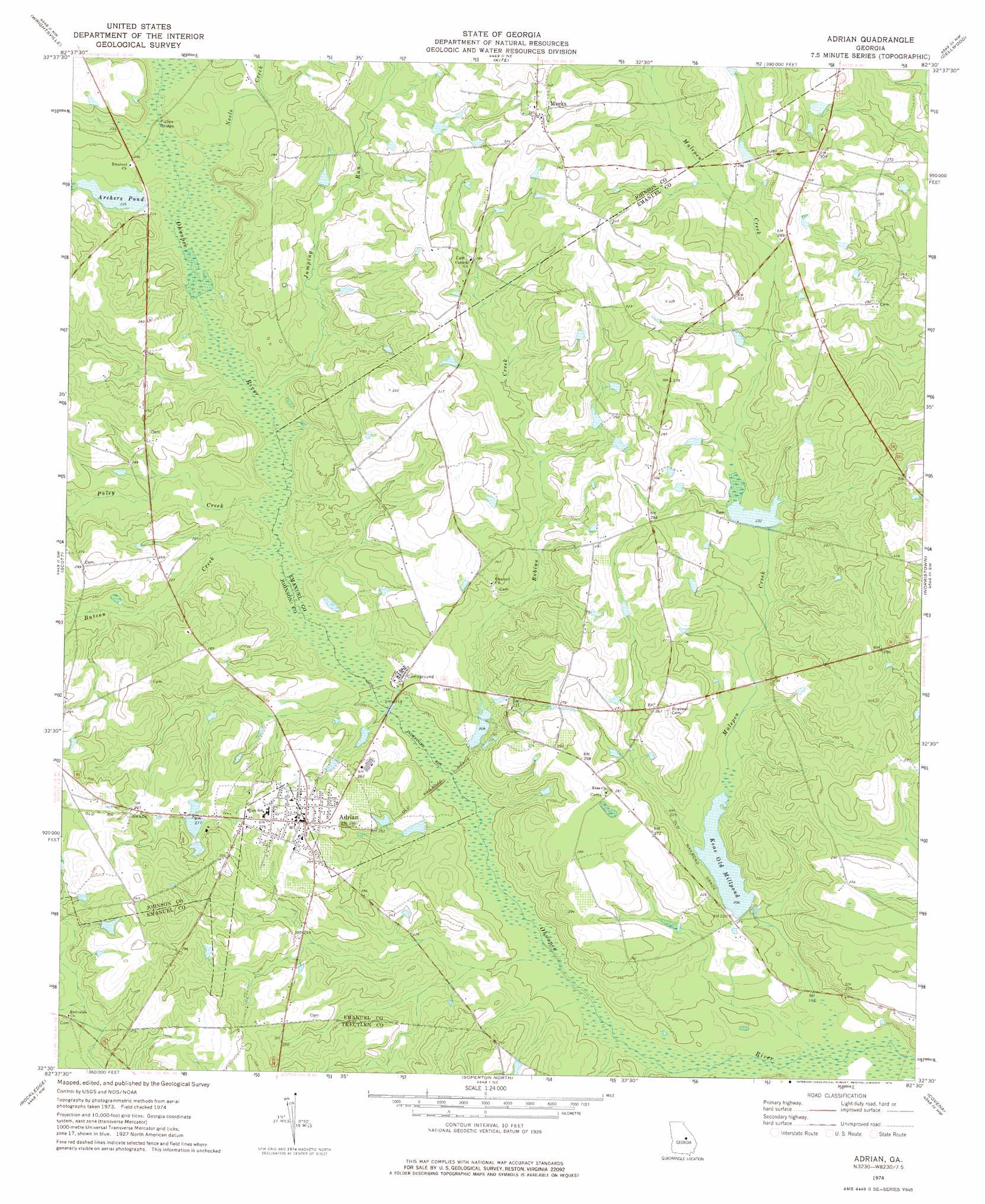
USGS Topo Quad 32082e5 - 1:24,000 scale
| Topo Map Name: | Adrian |
| USGS Topo Quad ID: | 32082e5 |
| Print Size: | ca. 21 1/4" wide x 27" high |
| Southeast Coordinates: | 32.5° N latitude / 82.5° W longitude |
| Map Center Coordinates: | 32.5625° N latitude / 82.5625° W longitude |
| U.S. State: | GA |
| Filename: | o32082e5.jpg |
| Download Map JPG Image: | Adrian topo map 1:24,000 scale |
| Map Type: | Topographic |
| Topo Series: | 7.5´ |
| Map Scale: | 1:24,000 |
| Source of Map Images: | United States Geological Survey (USGS) |
| Alternate Map Versions: |
Adrian GA 1974, updated 1976 Download PDF Buy paper map Adrian GA 2011 Download PDF Buy paper map Adrian GA 2014 Download PDF Buy paper map |
1:24,000 Topo Quads surrounding Adrian
Irwins Crossroads |
Harrison |
Davisboro Se |
Wadley |
Colemans Lake |
Lovett |
Wrightsville |
Kite |
Dellwood |
Summertown |
East Dublin |
Scott |
Adrian |
Norristown |
Swainsboro |
Minter |
Rockledge |
Soperton North |
Covena |
Nunez |
Lowery |
Lothair |
Soperton South |
Oak Park Sw |
Oak Park |
> Back to 32082e1 at 1:100,000 scale
> Back to 32082a1 at 1:250,000 scale
> Back to U.S. Topo Maps home
Adrian topo map: Gazetteer
Adrian: Bridges
Pullen Bridge elevation 67m 219′Adrian: Dams
Adrian Housing Pond Dam elevation 84m 275′Archers Pond Dam elevation 68m 223′
Brazwell Pond Dam elevation 60m 196′
General Land Corporation Lake Dam elevation 70m 229′
Keas Old Millpond Dam elevation 61m 200′
Adrian: Populated Places
Adrian elevation 86m 282′Meeks elevation 103m 337′
Adrian: Post Offices
Adrian Post Office elevation 86m 282′Adrian: Reservoirs
Adrian Housing Pond elevation 84m 275′Archers Pond elevation 68m 223′
Brazwell Pond elevation 60m 196′
General Land Corporation Lake elevation 70m 229′
Keas Old Millpond elevation 61m 200′
Adrian: Streams
Batson Creek elevation 63m 206′Jumping Run elevation 64m 209′
Mulepen Creek elevation 57m 187′
Neels Creek elevation 66m 216′
Poley Creek elevation 63m 206′
Robins Creek elevation 60m 196′
Adrian digital topo map on disk
Buy this Adrian topo map showing relief, roads, GPS coordinates and other geographical features, as a high-resolution digital map file on DVD:
South Carolina, Western North Carolina & Northeastern Georgia
Buy digital topo maps: South Carolina, Western North Carolina & Northeastern Georgia