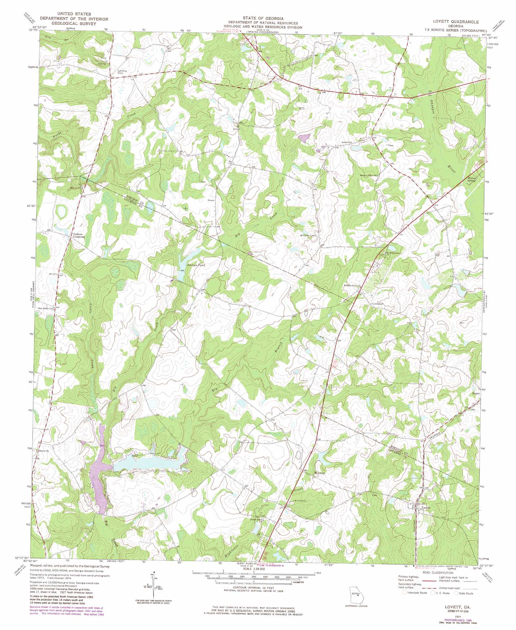
Lovett Topo Map Georgia
To zoom in, hover over the map of Lovett
USGS Topo Quad 32082f7 - 1:24,000 scale
| Topo Map Name: | Lovett |
| USGS Topo Quad ID: | 32082f7 |
| Print Size: | ca. 21 1/4" wide x 27" high |
| Southeast Coordinates: | 32.625° N latitude / 82.75° W longitude |
| Map Center Coordinates: | 32.6875° N latitude / 82.8125° W longitude |
| U.S. State: | GA |
| Filename: | o32082f7.jpg |
| Download Map JPG Image: | Lovett topo map 1:24,000 scale |
| Map Type: | Topographic |
| Topo Series: | 7.5´ |
| Map Scale: | 1:24,000 |
| Source of Map Images: | United States Geological Survey (USGS) |
| Alternate Map Versions: |
Lovett GA 1974, updated 1976 Download PDF Buy paper map Lovett GA 1974, updated 1986 Download PDF Buy paper map Lovett GA 2011 Download PDF Buy paper map Lovett GA 2014 Download PDF Buy paper map |
1:24,000 Topo Quads surrounding Lovett
Gumm Pond |
Tabernacle |
Sandersville |
Riddleville |
Davisboro |
Toomsboro |
Oconee |
Irwins Crossroads |
Harrison |
Davisboro Se |
Nicklesville |
Cow Hell Swamp |
Lovett |
Wrightsville |
Kite |
Dudley |
Dublin |
East Dublin |
Scott |
Adrian |
Dexter |
Rentz |
Minter |
Rockledge |
Soperton North |
> Back to 32082e1 at 1:100,000 scale
> Back to 32082a1 at 1:250,000 scale
> Back to U.S. Topo Maps home
Lovett topo map: Gazetteer
Lovett: Dams
Davis Lake Dam elevation 92m 301′Jackson Pond Dam elevation 81m 265′
Stanley Lake Dam elevation 88m 288′
Thunder Springs Lake Dam elevation 71m 232′
Lovett: Populated Places
Lovett elevation 102m 334′Midway elevation 90m 295′
Tuckers Crossroad elevation 95m 311′
Lovett: Reservoirs
Ben Hall Lake elevation 71m 232′Davis Lake elevation 92m 301′
Jackson Pond elevation 81m 265′
Stanley Lake elevation 88m 288′
Thunder Springs Lake elevation 71m 232′
Lovett: Springs
Mason Spring elevation 86m 282′Lovett: Streams
Big Branch elevation 64m 209′Little Creek elevation 64m 209′
Lovett digital topo map on disk
Buy this Lovett topo map showing relief, roads, GPS coordinates and other geographical features, as a high-resolution digital map file on DVD:
South Carolina, Western North Carolina & Northeastern Georgia
Buy digital topo maps: South Carolina, Western North Carolina & Northeastern Georgia