Bellevue Topo Map Georgia
To zoom in, hover over the map of Bellevue
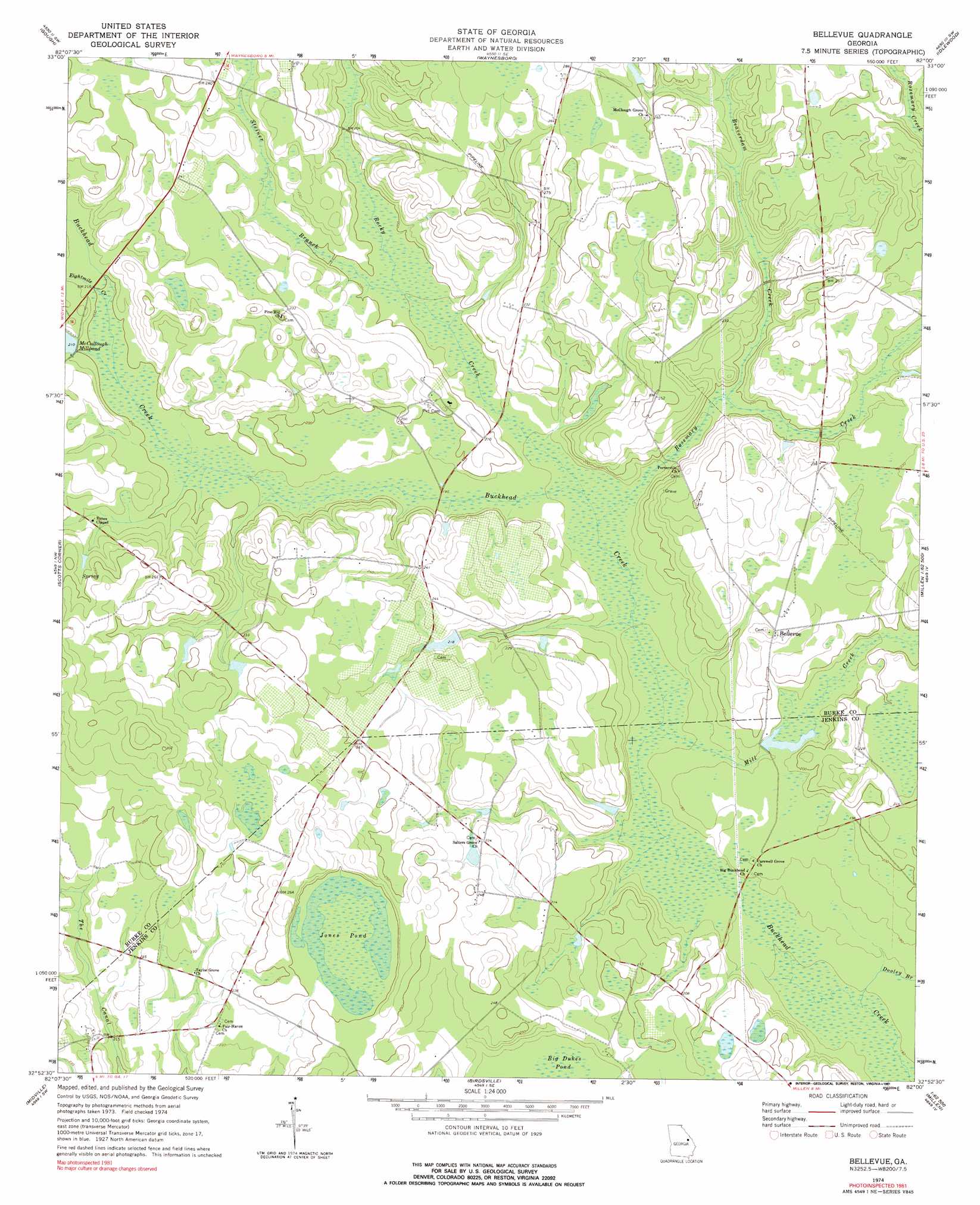
USGS Topo Quad 32082h1 - 1:24,000 scale
| Topo Map Name: | Bellevue |
| USGS Topo Quad ID: | 32082h1 |
| Print Size: | ca. 21 1/4" wide x 27" high |
| Southeast Coordinates: | 32.875° N latitude / 82° W longitude |
| Map Center Coordinates: | 32.9375° N latitude / 82.0625° W longitude |
| U.S. State: | GA |
| Filename: | o32082h1.jpg |
| Download Map JPG Image: | Bellevue topo map 1:24,000 scale |
| Map Type: | Topographic |
| Topo Series: | 7.5´ |
| Map Scale: | 1:24,000 |
| Source of Map Images: | United States Geological Survey (USGS) |
| Alternate Map Versions: |
Bellevue GA 1974, updated 1976 Download PDF Buy paper map Bellevue GA 1974, updated 1991 Download PDF Buy paper map Bellevue GA 2011 Download PDF Buy paper map Bellevue GA 2014 Download PDF Buy paper map |
1:24,000 Topo Quads surrounding Bellevue
Matthews |
Keysville |
Storys Millpond |
Mcbean |
Shell Bluff Landing |
Kellys Pond |
Gough |
Waynesboro |
Idlewood |
Alexander |
Old Town |
Scotts Corner |
Bellevue |
Perkins |
Sardis |
Colemans Lake |
Midville |
Birdsville |
Millen |
Bay Branch |
Summertown |
Canoochee |
Garfield |
Four Points |
Rocky Ford |
> Back to 32082e1 at 1:100,000 scale
> Back to 32082a1 at 1:250,000 scale
> Back to U.S. Topo Maps home
Bellevue topo map: Gazetteer
Bellevue: Dams
Carswell Lake Dam elevation 58m 190′Knight Irrigation Dam Upper elevation 65m 213′
Knight Lake Dam elevation 62m 203′
Lower Miller Lake Dam elevation 65m 213′
McCullough Millpond Dam elevation 62m 203′
Miller Lake Dam elevation 66m 216′
Bellevue: Lakes
Jones Pond elevation 75m 246′Bellevue: Populated Places
Bellevue elevation 67m 219′Bellevue: Reservoirs
Carswell Lake elevation 58m 190′Knight Lake elevation 62m 203′
Lower Miller Lake elevation 65m 213′
McCullough Millpond elevation 62m 203′
Miller Lake elevation 66m 216′
Bellevue: Streams
Beaverdam Creek elevation 58m 190′Dooley Branch elevation 48m 157′
Eightmile Creek elevation 60m 196′
Mill Creek elevation 50m 164′
Rocky Creek elevation 54m 177′
Rosemary Creek elevation 53m 173′
Steiner Branch elevation 58m 190′
Bellevue digital topo map on disk
Buy this Bellevue topo map showing relief, roads, GPS coordinates and other geographical features, as a high-resolution digital map file on DVD:
South Carolina, Western North Carolina & Northeastern Georgia
Buy digital topo maps: South Carolina, Western North Carolina & Northeastern Georgia