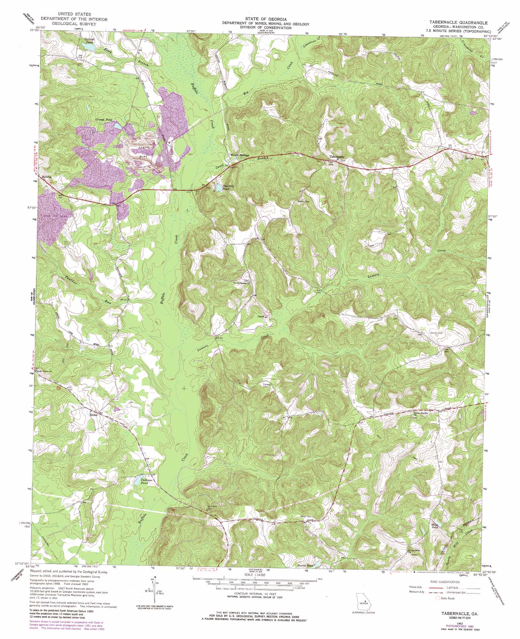
Tabernacle Topo Map Georgia
To zoom in, hover over the map of Tabernacle
USGS Topo Quad 32082h8 - 1:24,000 scale
| Topo Map Name: | Tabernacle |
| USGS Topo Quad ID: | 32082h8 |
| Print Size: | ca. 21 1/4" wide x 27" high |
| Southeast Coordinates: | 32.875° N latitude / 82.875° W longitude |
| Map Center Coordinates: | 32.9375° N latitude / 82.9375° W longitude |
| U.S. State: | GA |
| Filename: | o32082h8.jpg |
| Download Map JPG Image: | Tabernacle topo map 1:24,000 scale |
| Map Type: | Topographic |
| Topo Series: | 7.5´ |
| Map Scale: | 1:24,000 |
| Source of Map Images: | United States Geological Survey (USGS) |
| Alternate Map Versions: |
Tabernacle GA 1962, updated 1963 Download PDF Buy paper map Tabernacle GA 1962, updated 1986 Download PDF Buy paper map Tabernacle GA 2011 Download PDF Buy paper map Tabernacle GA 2014 Download PDF Buy paper map |
1:24,000 Topo Quads surrounding Tabernacle
Lake Sinclair East |
Devereux |
Warthen Nw |
Warthen Ne |
Mitchell |
Milledgeville |
Friendship |
Deepstep |
Warthen |
Downs |
Napier Pond |
Gumm Pond |
Tabernacle |
Sandersville |
Riddleville |
Irwinton |
Toomsboro |
Oconee |
Irwins Crossroads |
Harrison |
Stuckey Boone Lake |
Nicklesville |
Cow Hell Swamp |
Lovett |
Wrightsville |
> Back to 32082e1 at 1:100,000 scale
> Back to 32082a1 at 1:250,000 scale
> Back to U.S. Topo Maps home
Tabernacle topo map: Gazetteer
Tabernacle: Bridges
Sheppards Bridge elevation 64m 209′Tabernacle: Dams
Gorbutt Pond Dam elevation 80m 262′Tabernacle: Lakes
Mays Pond elevation 98m 321′Purvis Pond elevation 83m 272′
Tabernacle: Populated Places
Brook Springs elevation 72m 236′Ennis elevation 88m 288′
Hebron elevation 119m 390′
Tabernacle elevation 140m 459′
Tabernacle: Reservoirs
Cochran Pond elevation 64m 209′Doolittle Pond elevation 79m 259′
George Pond elevation 76m 249′
Gorbutt Pond elevation 80m 262′
Tabernacle: Streams
Black Branch elevation 70m 229′Canal Branch elevation 68m 223′
Cox Branch elevation 71m 232′
Deepstep Creek elevation 72m 236′
Dennard Branch elevation 71m 232′
Doolittle Branch elevation 81m 265′
Keg Creek elevation 69m 226′
Kitten Branch elevation 79m 259′
Lamars Creek elevation 64m 209′
Limestone Creek elevation 71m 232′
Panther Run elevation 65m 213′
Thompkins Branch elevation 81m 265′
Wheeler Creek elevation 62m 203′
Tabernacle digital topo map on disk
Buy this Tabernacle topo map showing relief, roads, GPS coordinates and other geographical features, as a high-resolution digital map file on DVD:
South Carolina, Western North Carolina & Northeastern Georgia
Buy digital topo maps: South Carolina, Western North Carolina & Northeastern Georgia