Drayton Topo Map Georgia
To zoom in, hover over the map of Drayton
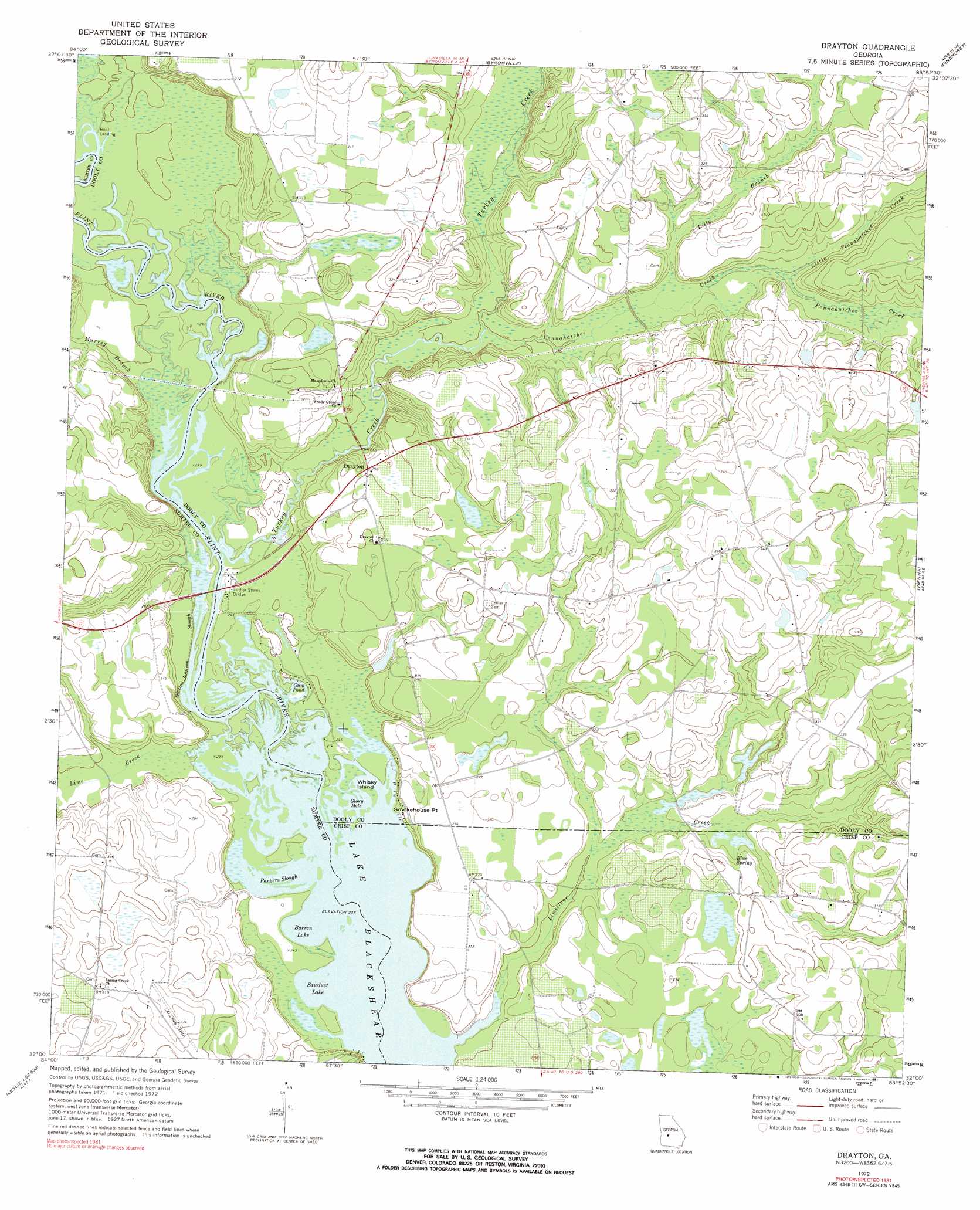
USGS Topo Quad 32083a8 - 1:24,000 scale
| Topo Map Name: | Drayton |
| USGS Topo Quad ID: | 32083a8 |
| Print Size: | ca. 21 1/4" wide x 27" high |
| Southeast Coordinates: | 32° N latitude / 83.875° W longitude |
| Map Center Coordinates: | 32.0625° N latitude / 83.9375° W longitude |
| U.S. State: | GA |
| Filename: | o32083a8.jpg |
| Download Map JPG Image: | Drayton topo map 1:24,000 scale |
| Map Type: | Topographic |
| Topo Series: | 7.5´ |
| Map Scale: | 1:24,000 |
| Source of Map Images: | United States Geological Survey (USGS) |
| Alternate Map Versions: |
Drayton GA 1972, updated 1974 Download PDF Buy paper map Drayton GA 1972, updated 1991 Download PDF Buy paper map Drayton GA 2011 Download PDF Buy paper map Drayton GA 2014 Download PDF Buy paper map |
1:24,000 Topo Quads surrounding Drayton
Ideal South |
Montezuma |
Marshallville Sw |
Henderson |
Unadilla |
Andersonville |
Pennington |
Byromville |
Pinehurst |
Pineview Nw |
Americus |
Methvins |
Drayton |
Vienna |
Pineview Sw |
Smithville East |
Leslie |
Cobb |
Cordele |
Penia |
Neyami |
Leslie Se |
Warwick |
Pateville |
Arabi |
> Back to 32083a1 at 1:100,000 scale
> Back to 32082a1 at 1:250,000 scale
> Back to U.S. Topo Maps home
Drayton topo map: Gazetteer
Drayton: Bays
Glory Hole elevation 72m 236′Drayton: Bridges
Luther Storey Bridge elevation 72m 236′Drayton: Capes
Smokehouse Point elevation 73m 239′Drayton: Cliffs
Danville Bluff elevation 72m 236′Drayton: Crossings
Murrys Ferry (historical) elevation 72m 236′Drayton: Dams
Taylor Lake Dam North elevation 91m 298′Drayton: Guts
Parkers Slough elevation 72m 236′Drayton: Islands
Whisky Island elevation 72m 236′Drayton: Lakes
Barren Lake elevation 72m 236′Gum Pond elevation 72m 236′
Holland Park elevation 86m 282′
Lake Sawdust elevation 72m 236′
Mile Pond elevation 81m 265′
Drayton: Populated Places
Danville (historical) elevation 85m 278′Drayton elevation 90m 295′
Drayton: Reservoirs
Taylor Lake North elevation 91m 298′Drayton: Springs
Blue Spring elevation 82m 269′Collier Spring elevation 80m 262′
Drayton: Streams
Gleaton-Johnson Slough elevation 73m 239′Lilly Branch elevation 79m 259′
Lime Creek elevation 72m 236′
Limestone Creek elevation 72m 236′
Limestone Creek elevation 80m 262′
Little Pennahatchee Creek elevation 79m 259′
Murray Branch elevation 73m 239′
Pennahatchee Creek elevation 76m 249′
Turkey Creek elevation 72m 236′
Drayton digital topo map on disk
Buy this Drayton topo map showing relief, roads, GPS coordinates and other geographical features, as a high-resolution digital map file on DVD:
South Carolina, Western North Carolina & Northeastern Georgia
Buy digital topo maps: South Carolina, Western North Carolina & Northeastern Georgia