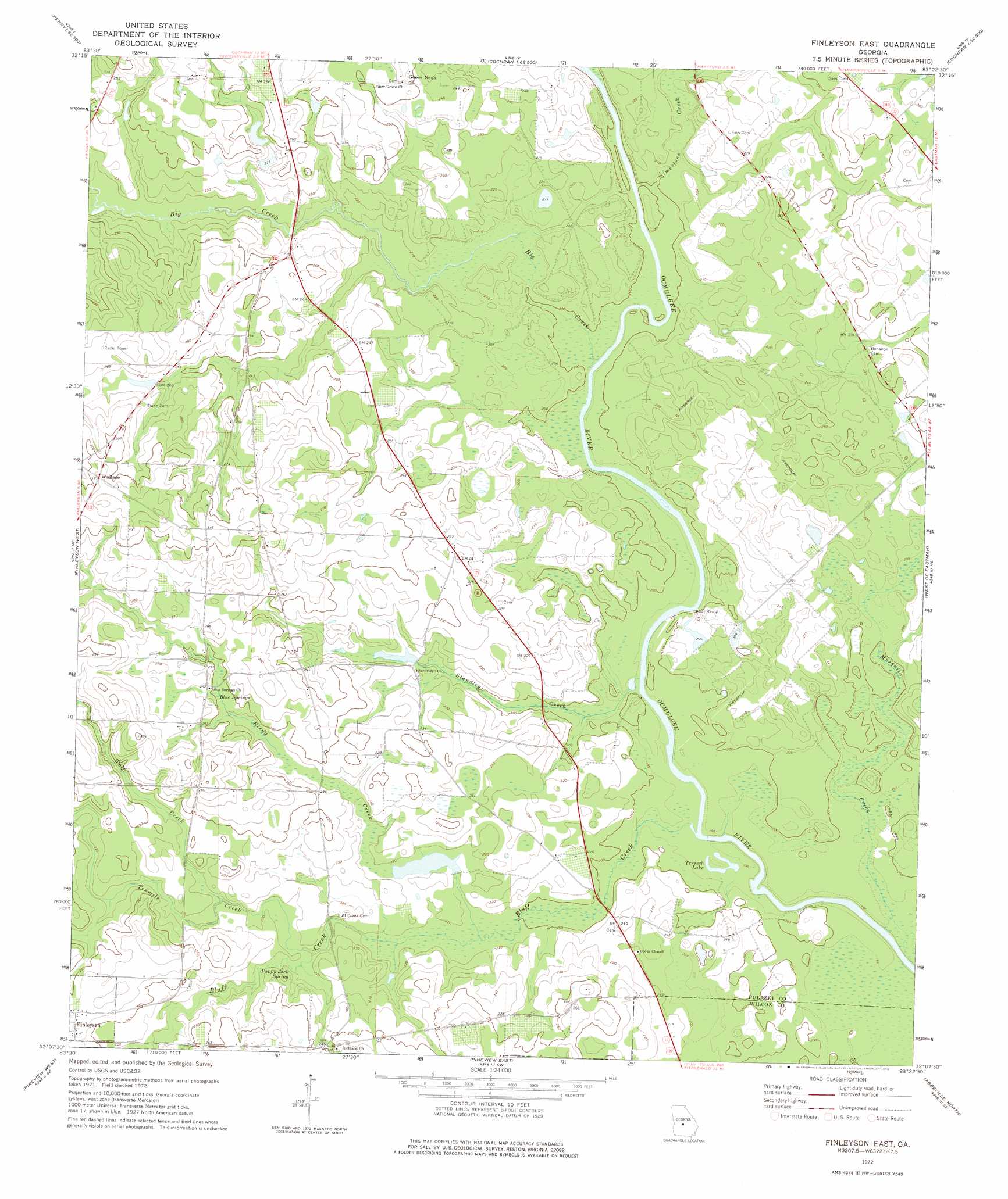
Finleyson East Topo Map Georgia
To zoom in, hover over the map of Finleyson East
USGS Topo Quad 32083b4 - 1:24,000 scale
| Topo Map Name: | Finleyson East |
| USGS Topo Quad ID: | 32083b4 |
| Print Size: | ca. 21 1/4" wide x 27" high |
| Southeast Coordinates: | 32.125° N latitude / 83.375° W longitude |
| Map Center Coordinates: | 32.1875° N latitude / 83.4375° W longitude |
| U.S. State: | GA |
| Filename: | o32083b4.jpg |
| Download Map JPG Image: | Finleyson East topo map 1:24,000 scale |
| Map Type: | Topographic |
| Topo Series: | 7.5´ |
| Map Scale: | 1:24,000 |
| Source of Map Images: | United States Geological Survey (USGS) |
| Alternate Map Versions: |
Finleyson East GA 1972, updated 1975 Download PDF Buy paper map Finleyson East GA 2011 Download PDF Buy paper map Finleyson East GA 2014 Download PDF Buy paper map |
1:24,000 Topo Quads surrounding Finleyson East
Perry East |
Hayneville |
Westlake |
Cochran |
Chester |
Unadilla |
Klondike |
Hawkinsville |
Empire |
Yonkers |
Pineview Nw |
Finleyson West |
Finleyson East |
West Of Eastman |
Eastman |
Pineview Sw |
Pineview West |
Pineview East |
Abbeville North |
Lake Cypress |
Penia |
Pitts |
Rochelle |
Abbeville South |
Rhine |
> Back to 32083a1 at 1:100,000 scale
> Back to 32082a1 at 1:250,000 scale
> Back to U.S. Topo Maps home
Finleyson East topo map: Gazetteer
Finleyson East: Cliffs
Cotton Bluff elevation 62m 203′Finleyson East: Dams
Dawson Lake Dam elevation 64m 209′Finleyson East: Lakes
Treisch Lake elevation 58m 190′Finleyson East: Populated Places
Goose Neck elevation 76m 249′Wallace elevation 95m 311′
Finleyson East: Reservoirs
Dawson Lake elevation 64m 209′Finleyson East: Springs
Blue Springs elevation 75m 246′Pappy Jack Spring elevation 69m 226′
Finleyson East: Streams
Big Creek elevation 59m 193′Bluff Creek elevation 58m 190′
Cedar Creek elevation 65m 213′
Limestone Creek elevation 61m 200′
Mosquito Creek elevation 58m 190′
Reedy Creek elevation 62m 203′
Standley Creek elevation 58m 190′
Tenmile Creek elevation 66m 216′
Wolf Creek elevation 67m 219′
Finleyson East digital topo map on disk
Buy this Finleyson East topo map showing relief, roads, GPS coordinates and other geographical features, as a high-resolution digital map file on DVD:
South Carolina, Western North Carolina & Northeastern Georgia
Buy digital topo maps: South Carolina, Western North Carolina & Northeastern Georgia