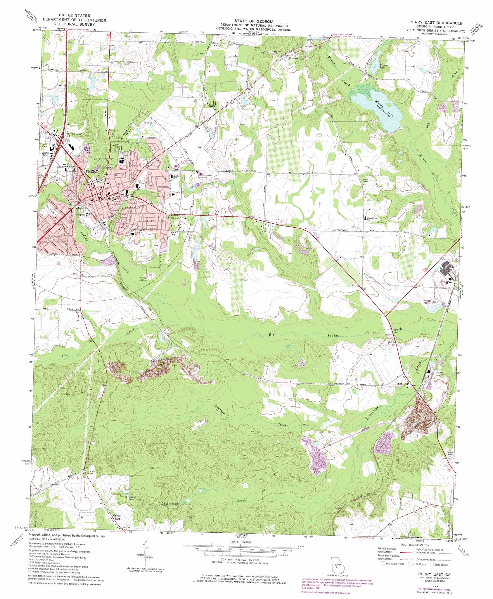
Perry East Topo Map Georgia
To zoom in, hover over the map of Perry East
USGS Topo Quad 32083d6 - 1:24,000 scale
| Topo Map Name: | Perry East |
| USGS Topo Quad ID: | 32083d6 |
| Print Size: | ca. 21 1/4" wide x 27" high |
| Southeast Coordinates: | 32.375° N latitude / 83.625° W longitude |
| Map Center Coordinates: | 32.4375° N latitude / 83.6875° W longitude |
| U.S. State: | GA |
| Filename: | o32083d6.jpg |
| Download Map JPG Image: | Perry East topo map 1:24,000 scale |
| Map Type: | Topographic |
| Topo Series: | 7.5´ |
| Map Scale: | 1:24,000 |
| Source of Map Images: | United States Geological Survey (USGS) |
| Alternate Map Versions: |
Perry East GA 1973, updated 1977 Download PDF Buy paper map Perry East GA 1973, updated 1986 Download PDF Buy paper map Perry East GA 2011 Download PDF Buy paper map Perry East GA 2014 Download PDF Buy paper map |
1:24,000 Topo Quads surrounding Perry East
Knoxville |
Byron |
Warner Robins Nw |
Warner Robins Ne |
Marion |
Fort Valley West |
Fort Valley East |
Warner Robins Sw |
Warner Robins Se |
Tarversville |
Marshallville |
Perry West |
Perry East |
Hayneville |
Westlake |
Marshallville Sw |
Henderson |
Unadilla |
Klondike |
Hawkinsville |
Byromville |
Pinehurst |
Pineview Nw |
Finleyson West |
Finleyson East |
> Back to 32083a1 at 1:100,000 scale
> Back to 32082a1 at 1:250,000 scale
> Back to U.S. Topo Maps home
Perry East topo map: Gazetteer
Perry East: Crossings
Exit 43A elevation 119m 390′Interchange 43 elevation 121m 396′
Perry East: Dams
Hackney Lake Dam elevation 110m 360′Houston Lake Dam elevation 87m 285′
Jacobs Lake Dam elevation 107m 351′
Kersey Lake Dam elevation 83m 272′
Meadows Lake Dam elevation 89m 291′
Mossy Lake Dam elevation 80m 262′
Mullins Lake Dam elevation 87m 285′
Perry East: Lakes
Greens Pond elevation 133m 436′Perry East: Parks
Barbara Calhoun Park elevation 109m 357′Creekwood Park elevation 103m 337′
Rozar Park elevation 107m 351′
Perry East: Populated Places
Bonners Camp elevation 111m 364′Clinchfield elevation 79m 259′
Devonwood elevation 108m 354′
Fox Ridge Estates elevation 111m 364′
Grove Park elevation 150m 492′
Houston Lake elevation 112m 367′
Laurel Crest Subdivision elevation 116m 380′
Lea Glen elevation 98m 321′
Pabst elevation 91m 298′
Perry elevation 108m 354′
Wildwood Estates elevation 113m 370′
Willow Run elevation 100m 328′
Perry East: Post Offices
Perry Post Office elevation 108m 354′Perry East: Reservoirs
Hackney Lake elevation 110m 360′Houston Lake elevation 87m 285′
Jacobs Lake elevation 107m 351′
Kersey Lake elevation 83m 272′
Kerysey Lake elevation 83m 272′
Meadows Lake elevation 89m 291′
Mossy Lake elevation 81m 265′
Mullins Lake elevation 87m 285′
Perry East: Streams
Bear Branch elevation 78m 255′Berry Branch elevation 84m 275′
Flat Creek elevation 82m 269′
Okeetuck Creek elevation 78m 255′
Redding Branch elevation 81m 265′
Perry East digital topo map on disk
Buy this Perry East topo map showing relief, roads, GPS coordinates and other geographical features, as a high-resolution digital map file on DVD:
South Carolina, Western North Carolina & Northeastern Georgia
Buy digital topo maps: South Carolina, Western North Carolina & Northeastern Georgia