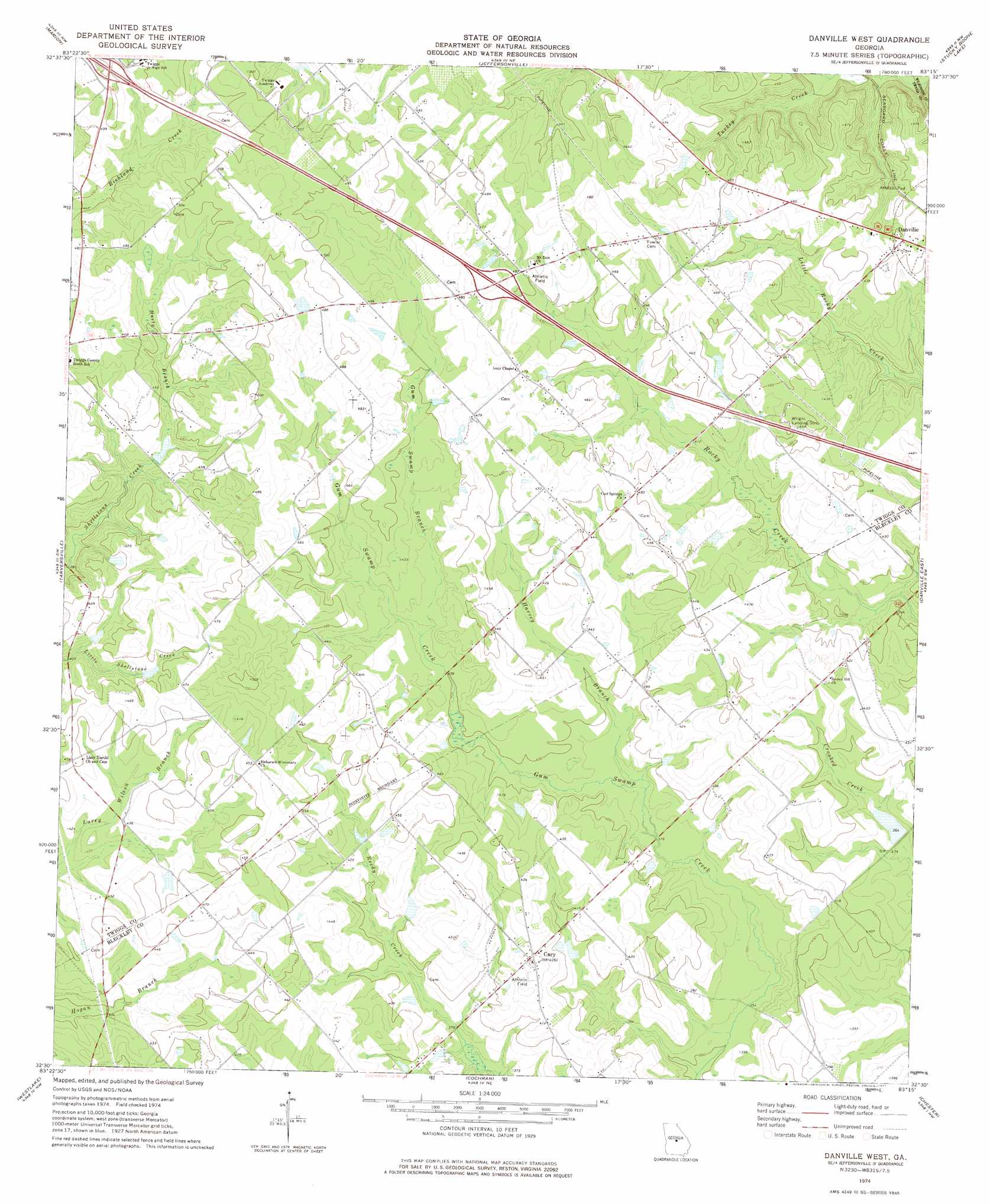
Danville West Topo Map Georgia
To zoom in, hover over the map of Danville West
USGS Topo Quad 32083e3 - 1:24,000 scale
| Topo Map Name: | Danville West |
| USGS Topo Quad ID: | 32083e3 |
| Print Size: | ca. 21 1/4" wide x 27" high |
| Southeast Coordinates: | 32.5° N latitude / 83.25° W longitude |
| Map Center Coordinates: | 32.5625° N latitude / 83.3125° W longitude |
| U.S. State: | GA |
| Filename: | o32083e3.jpg |
| Download Map JPG Image: | Danville West topo map 1:24,000 scale |
| Map Type: | Topographic |
| Topo Series: | 7.5´ |
| Map Scale: | 1:24,000 |
| Source of Map Images: | United States Geological Survey (USGS) |
| Alternate Map Versions: |
Danville West GA 1974, updated 1977 Download PDF Buy paper map Danville West GA 2011 Download PDF Buy paper map Danville West GA 2014 Download PDF Buy paper map |
1:24,000 Topo Quads surrounding Danville West
Macon East |
Dry Branch |
Massey Hill |
Irwinton |
Toomsboro |
Warner Robins Ne |
Marion |
Jeffersonville |
Stuckey Boone Lake |
Nicklesville |
Warner Robins Se |
Tarversville |
Danville West |
Danville East |
Dudley |
Hayneville |
Westlake |
Cochran |
Chester |
Dexter |
Klondike |
Hawkinsville |
Empire |
Yonkers |
Cadwell |
> Back to 32083e1 at 1:100,000 scale
> Back to 32082a1 at 1:250,000 scale
> Back to U.S. Topo Maps home
Danville West topo map: Gazetteer
Danville West: Airports
Danville Airpark elevation 139m 456′Danville West: Crossings
Exit 8 elevation 152m 498′Exit 9 elevation 143m 469′
Danville West: Dams
Cason Lake Dam elevation 128m 419′Land Dam elevation 113m 370′
Danville West: Populated Places
Brown Hill elevation 128m 419′Cary elevation 129m 423′
Danville West: Reservoirs
Cason Lake elevation 128m 419′Land Lake elevation 113m 370′
Danville West: Streams
Gum Swamp Branch elevation 124m 406′Harvey Branch elevation 114m 374′
Hasty Branch elevation 130m 426′
Danville West digital topo map on disk
Buy this Danville West topo map showing relief, roads, GPS coordinates and other geographical features, as a high-resolution digital map file on DVD:
South Carolina, Western North Carolina & Northeastern Georgia
Buy digital topo maps: South Carolina, Western North Carolina & Northeastern Georgia