Warner Robins Ne Topo Map Georgia
To zoom in, hover over the map of Warner Robins Ne
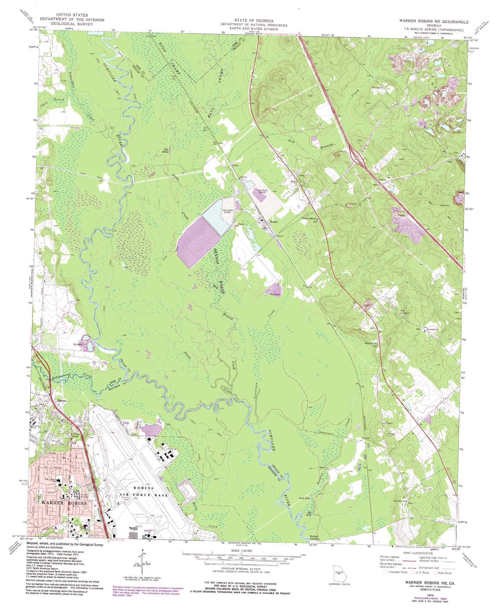
USGS Topo Quad 32083f5 - 1:24,000 scale
| Topo Map Name: | Warner Robins Ne |
| USGS Topo Quad ID: | 32083f5 |
| Print Size: | ca. 21 1/4" wide x 27" high |
| Southeast Coordinates: | 32.625° N latitude / 83.5° W longitude |
| Map Center Coordinates: | 32.6875° N latitude / 83.5625° W longitude |
| U.S. State: | GA |
| Filename: | o32083f5.jpg |
| Download Map JPG Image: | Warner Robins Ne topo map 1:24,000 scale |
| Map Type: | Topographic |
| Topo Series: | 7.5´ |
| Map Scale: | 1:24,000 |
| Source of Map Images: | United States Geological Survey (USGS) |
| Alternate Map Versions: |
Warner Robins NE GA 1973, updated 1977 Download PDF Buy paper map Warner Robins NE GA 1973, updated 1984 Download PDF Buy paper map Warner Robins NE GA 2011 Download PDF Buy paper map Warner Robins NE GA 2014 Download PDF Buy paper map |
1:24,000 Topo Quads surrounding Warner Robins Ne
Bolingbroke |
Macon Nw |
Macon Ne |
James |
Gordon |
Lizella |
Macon West |
Macon East |
Dry Branch |
Massey Hill |
Byron |
Warner Robins Nw |
Warner Robins Ne |
Marion |
Jeffersonville |
Fort Valley East |
Warner Robins Sw |
Warner Robins Se |
Tarversville |
Danville West |
Perry West |
Perry East |
Hayneville |
Westlake |
Cochran |
> Back to 32083e1 at 1:100,000 scale
> Back to 32082a1 at 1:250,000 scale
> Back to U.S. Topo Maps home
Warner Robins Ne topo map: Gazetteer
Warner Robins Ne: Crossings
Exit 6 elevation 115m 377′Warner Robins Ne: Lakes
Big Eddy elevation 80m 262′Eel Hole elevation 75m 246′
Jack Hole elevation 76m 249′
Warner Robins Ne: Parks
Alex Ferguson Memorial Park elevation 101m 331′Sewell Circle Park elevation 112m 367′
Warner Robins Ne: Populated Places
Elberta elevation 84m 275′Huber elevation 83m 272′
Reids elevation 83m 272′
Richardson Estates elevation 103m 337′
Warner Robins Ne: Streams
Dry Branch Creek elevation 76m 249′Echeconnee Creek elevation 76m 249′
Johns Branch elevation 81m 265′
Rosston Creek elevation 75m 246′
Stone Creek elevation 76m 249′
Streetman Creek elevation 76m 249′
Tobesofkee Creek elevation 79m 259′
Warner Robins Ne: Swamps
Bond Swamp elevation 82m 269′Denson Marsh elevation 78m 255′
Rays Swamp elevation 81m 265′
Warner Robins Ne digital topo map on disk
Buy this Warner Robins Ne topo map showing relief, roads, GPS coordinates and other geographical features, as a high-resolution digital map file on DVD:
South Carolina, Western North Carolina & Northeastern Georgia
Buy digital topo maps: South Carolina, Western North Carolina & Northeastern Georgia