Napier Pond Topo Map Georgia
To zoom in, hover over the map of Napier Pond
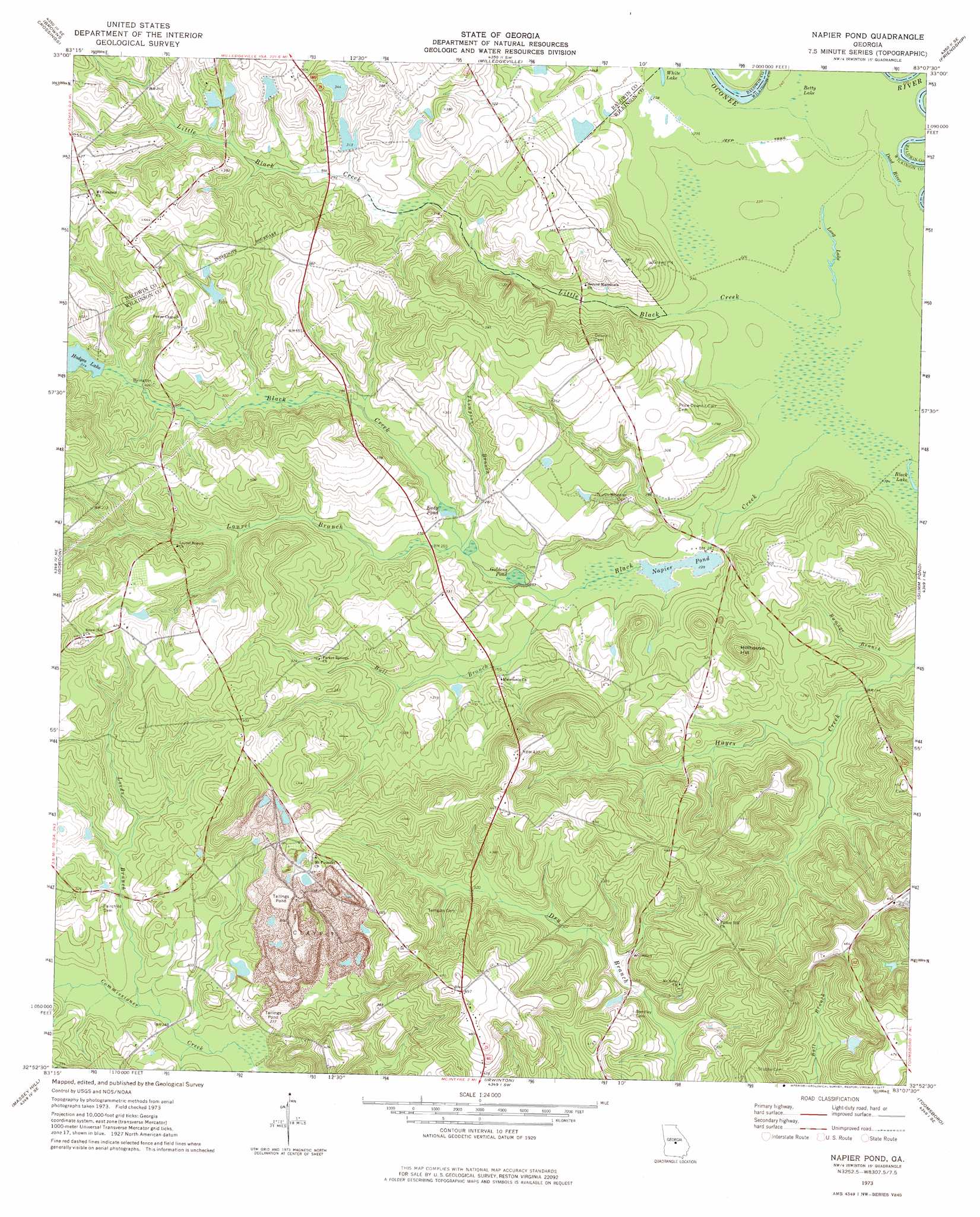
USGS Topo Quad 32083h2 - 1:24,000 scale
| Topo Map Name: | Napier Pond |
| USGS Topo Quad ID: | 32083h2 |
| Print Size: | ca. 21 1/4" wide x 27" high |
| Southeast Coordinates: | 32.875° N latitude / 83.125° W longitude |
| Map Center Coordinates: | 32.9375° N latitude / 83.1875° W longitude |
| U.S. State: | GA |
| Filename: | o32083h2.jpg |
| Download Map JPG Image: | Napier Pond topo map 1:24,000 scale |
| Map Type: | Topographic |
| Topo Series: | 7.5´ |
| Map Scale: | 1:24,000 |
| Source of Map Images: | United States Geological Survey (USGS) |
| Alternate Map Versions: |
Napier Pond GA 1973, updated 1977 Download PDF Buy paper map Napier Pond GA 2011 Download PDF Buy paper map Napier Pond GA 2014 Download PDF Buy paper map |
1:24,000 Topo Quads surrounding Napier Pond
Resseaus Crossroads |
Lake Sinclair West |
Lake Sinclair East |
Devereux |
Warthen Nw |
Haddock |
Browns Crossing |
Milledgeville |
Friendship |
Deepstep |
James |
Gordon |
Napier Pond |
Gumm Pond |
Tabernacle |
Dry Branch |
Massey Hill |
Irwinton |
Toomsboro |
Oconee |
Marion |
Jeffersonville |
Stuckey Boone Lake |
Nicklesville |
Cow Hell Swamp |
> Back to 32083e1 at 1:100,000 scale
> Back to 32082a1 at 1:250,000 scale
> Back to U.S. Topo Maps home
Napier Pond topo map: Gazetteer
Napier Pond: Bridges
Johns Bridge elevation 85m 278′Napier Pond: Dams
Beckham Lake Dam elevation 110m 360′Forestry Pond Dam Number One elevation 91m 298′
Forestry Pond Dam Number Two elevation 106m 347′
Georgia State Hospital Lake West Dam elevation 104m 341′
Hodges Lake Dam elevation 94m 308′
Hollinshead Pond Dam elevation 83m 272′
Hospital Lake Number One Dam elevation 92m 301′
Jones Pond Dam elevation 101m 331′
Napier Pond Dam elevation 70m 229′
Scott Lake Dam elevation 100m 328′
Napier Pond: Gaps
Dead River elevation 70m 229′Napier Pond: Lakes
Betty Lake elevation 72m 236′Long Lake elevation 70m 229′
White Lake elevation 72m 236′
Napier Pond: Populated Places
Carr Corners (historical) elevation 123m 403′Goldens Mill (historical) elevation 76m 249′
Mount Carmel (historical) elevation 120m 393′
Mount Pleasant elevation 123m 403′
Youngblood Corners (historical) elevation 151m 495′
Napier Pond: Reservoirs
Beckham Lake elevation 110m 360′Eady Pond elevation 79m 259′
Forestry Pond Number Two elevation 106m 347′
Georgia State Hospital Lake elevation 91m 298′
Georgia State Hospital Lake West elevation 104m 341′
Goldens Pond elevation 76m 249′
Hodges Lake elevation 94m 308′
Hollinshead Pond elevation 83m 272′
Hospital Lake Number One elevation 92m 301′
Jones Pond elevation 101m 331′
Napier Pond elevation 70m 229′
Scott Lake elevation 100m 328′
Napier Pond: Streams
Blackkiln Branch elevation 79m 259′Bull Branch elevation 75m 246′
Laurel Branch elevation 77m 252′
Little Black Creek elevation 69m 226′
Lords Branch elevation 79m 259′
Thompson Branch elevation 77m 252′
Napier Pond: Summits
Hillhouse Hill elevation 125m 410′Napier Pond digital topo map on disk
Buy this Napier Pond topo map showing relief, roads, GPS coordinates and other geographical features, as a high-resolution digital map file on DVD:
South Carolina, Western North Carolina & Northeastern Georgia
Buy digital topo maps: South Carolina, Western North Carolina & Northeastern Georgia